Does a subdivision erosion-control plan cover your vacant lot home build?
Verify whether a subdivision erosion-control approval covers your lot, house disturbance, permittee, builder handoff, inspections, and closeout before sitework.
The short answer
Not automatically. Treat the developer’s statement as unverified until the recorded plat and lot number match the approved erosion plan, limits of disturbance, current permit or coverage record, responsible party, and maintenance duties. Ask the issuing authority in writing whether your proposed house, access, utilities, staging, and grading are covered. If the match or handoff is missing, place a written hold on clearing and excavation.Does a subdivision erosion-control plan cover your vacant lot home build?
Not automatically. Treat the developer’s statement as unverified until the recorded plat and lot number match the approved erosion plan, limits of disturbance, current permit or coverage record, responsible party, and maintenance duties. Ask the issuing authority in writing whether your proposed house, access, utilities, staging, and grading are covered. If the match or handoff is missing, place a written hold on clearing and excavation.
This guide applies to a United States homeowner buying or planning a vacant lot before contractor award. Its local examples are limited to Virginia, North Carolina, South Carolina, and the City of Richmond, Virginia. Those examples show why the answer must be jurisdiction-specific; they do not create one national subdivision rule. The words “covered,” “approved,” “permit,” “certificate,” “permittee,” and “responsible land disturber” can describe related but different records. Your decision is complete only when the authority, the documents, and the people responsible line up for this lot and this disturbance.
This decision belongs to Brictale’s land and feasibility journey, where site records, constraints, and buildability questions are resolved before a contractor is released to disturb the ground.
What does “covered” mean before a vacant-lot build? #
“Covered” means that the authority’s current record connects your specific parcel and proposed land disturbance to an approved erosion and sediment control plan, agreement, permit, or construction-stormwater coverage, and that a named person or entity is responsible for carrying it out and maintaining it. A subdivision-wide approval can be relevant evidence, but the phrase alone does not prove that your lot, house footprint, driveway, utility routes, staging area, and final grading fall inside its approved scope.
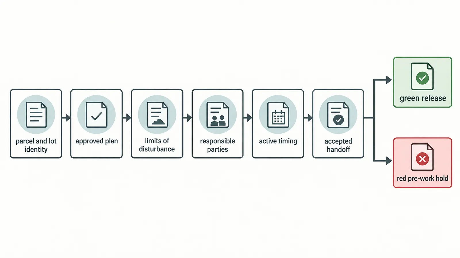
The practical test is a chain of six matches:
- Identity: the legal parcel, street address, tax parcel or lot number, and recorded subdivision plat agree.
- Plan: the authority-issued plan, agreement, approval letter, permit, or certificate is identified by number and revision or approval date.
- Disturbance: the mapped limits of disturbance include all work you expect, including temporary access, utility connections, stockpiles, soil export, and off-site tie-ins.
- Responsibility: the current owner, developer, builder, operator, permittee, financially responsible party, or responsible land disturber is identified for the activity that will actually happen.
- Timing: the approval or coverage is active, the start notice or preconstruction condition is satisfied, and no expiration, suspension, closeout, or unresolved violation prevents work.
- Handoff: the authority has accepted any transfer, new certificate, owner change, agreement, bond, inspection arrangement, or other step required before you or your builder begin.
If one of those matches is missing, the answer is not “yes.” It is “not yet verified.” That is a useful answer because it tells you what record to request and where to stop the sequence.
Why a broad subdivision statement is not enough
A subdivision may have been approved for roads, mass grading, stormwater facilities, and a planned sequence of lots. Your house may be built later by a different owner and builder, with a different footprint, driveway, well or sewer connection, utility trench, retaining feature, or grading concept. The approved common-plan documents might show typical individual-lot controls, but a typical detail is not the same as a written finding that your proposed disturbance fits without modification.
The same word can also conceal different boundaries. A recorded plat describes land ownership and lot geometry. An erosion plan describes control measures and disturbance assumptions. A construction-stormwater certificate can identify a permittee and coverage. A grading permit can be a local approval. A building permit concerns a different part of the project. A homeowner should collect all of these records rather than use one as a substitute for the others.
North Carolina’s current materials make this visible. Guilford County says that a lot within a subdivision or common plan of development must have an approved erosion control plan, a grading permit, and NCG01 coverage. Guilford County’s residential-lot guidance also distinguishes that treatment from an individual lot outside a subdivision. The distinction is local guidance from Guilford County, not a national shortcut.
North Carolina DEQ’s sample residential-plan conditions likewise require a subdivision plat or plan showing numbered lots and limits of disturbance. DEQ says those limits can include the lots, access to control measures, staging areas, and utilities that extend off site. The North Carolina DEQ plan materials are sample-plan guidance with stated assumptions, not an automatic approval for every site. They are nevertheless a strong records test: if the plan set cannot show how your lot and temporary work areas fit, ask for clarification before relying on it.
Originality brief
Current answers from agencies explain separate pieces: Virginia describes individual-lot coverage, Guilford County identifies subdivision-lot approvals, Greenville County describes lot-to-lot BMP duties, and Richmond describes a local single-family permit process. The missing homeowner decision is whether a developer’s broad statement is enough to release a purchase, builder award, clearing authorization, or excavation start.
The original contribution in this guide is the Subdivision coverage-and-responsibility register. It turns a verbal permit claim into a falsifiable record match.
Method: Match the recorded plat and lot number to the approved erosion plan or agreement, plan approval, permit or certificate reference, limits of disturbance, permittee, responsible land disturber, maintenance duty, start notice, inspections, and closeout or transfer evidence; mark a pre-work hold when any required match is missing.
Limitations: This is a homeowner document-control method, not a permit, legal opinion, title examination, engineering review, survey, or authority determination. Thresholds and transfer rules vary by jurisdiction and project facts; the issuing authority and qualified design professional control the site-specific answer.
The register is a document-control worksheet. It cannot establish that a plan is technically adequate, identify unrecorded obligations, or replace a written response from the issuing authority. Those limitations matter: the method identifies missing or contradictory records, while a qualified local professional may still need to revise the plan before work.
The next decision after this section is whether to request missing records, obtain written authority confirmation, or keep the transaction and sitework conditional. Do not ask your excavator to resolve the question by starting work. Clearing can change the facts the plan was designed to manage, and the owner may have difficulty proving when, why, and under whose authorization disturbance began.
How do you match the vacant lot to the actual disturbance boundary? #
Start with the recorded plat and a marked-up site plan, then compare every planned ground disturbance with the approved limits of disturbance; a lot-number match by itself is not enough. The homeowner’s first job is not to judge whether a silt fence looks adequate. It is to establish whether the plan’s geographic scope includes the work the house will require.
Collect the minimum record set
Ask the seller, developer, association if one exists, builder, civil engineer, and issuing authority for copies of the following:
- recorded subdivision plat, amendments, replats, easements, and the lot number;
- current tax parcel or parcel identification and street address;
- approved erosion and sediment control plan, including cover sheet, lot table, typical-lot sheets, details, notes, revisions, and approval letter;
- approved stormwater or drainage plan where it is part of the same submittal;
- land-disturbance, grading, erosion, or stormwater permit and its expiration or active status;
- construction-stormwater coverage, certificate of coverage, Notice of Intent, permit number, or local equivalent when the jurisdiction uses one;
- financial responsibility or ownership form and any developer or owner agreement;
- current limits-of-disturbance exhibit showing the house, driveway, utility routes, access, staging, stockpiles, and control measures;
- inspection reports, violation notices, stop-work releases, transfer records, and closeout or final-stabilization records;
- written instructions for preconstruction meeting, start notice, inspection request, bond or surety, and responsible-person designation.
Do not reject a record because it uses a different name. A local program may call the controlling document an erosion and sediment control plan, E&S plan, sediment-control plan, land-disturbance permit, grading permit, stormwater permit, agreement in lieu of plan, or certificate of coverage. Ask the authority which document controls and which record connects the lot to it.
Mark the proposed disturbance, not just the house
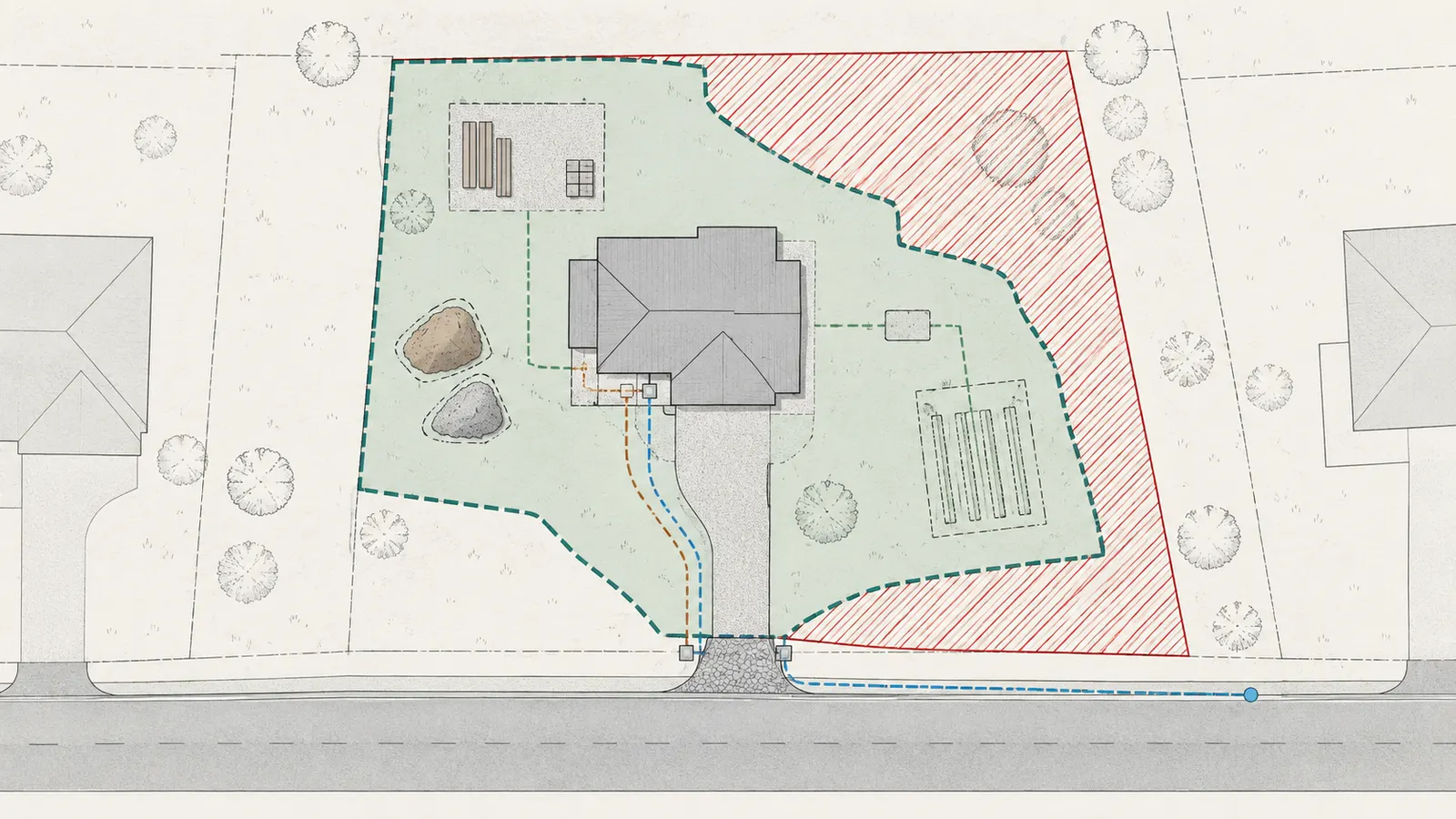
Draw or have a qualified designer draw the actual work envelope on the plat and plan. At minimum, show:
- house foundation, porches, steps, patios, retaining walls, tanks, and accessory structures;
- driveway, construction entrance, parking for delivery vehicles, and any road shoulder work;
- water, sewer, septic, well, electrical, gas, communications, and drainage trenches;
- clearing, grubbing, cut and fill, basement excavation, slope work, and grading transitions;
- material stockpiles, soil stockpiles, concrete washout, dumpsters, fuel or equipment areas;
- temporary sediment controls, inlet protection, diversion paths, and stabilization areas;
- off-site work in an easement, right of way, adjacent parcel, road, common open space, or utility corridor;
- the area disturbed by future final grading, even if it is not disturbed on the first day.
The relevant comparison is not “Is the house inside the subdivision?” It is “Does the approved disturbance polygon contain the house project as actually designed, including temporary and off-site work?” North Carolina DEQ’s sample-plan guidance explicitly calls out staging and utilities that may extend off site. That is why a narrow exhibit around the foundation can fail to cover a driveway connection or utility trench even when the address and lot number are correct. DEQ’s residential-plan conditions support checking those areas individually.
Check assumptions that can invalidate a typical-lot sheet
Typical plans are useful only if their assumptions describe the lot. North Carolina DEQ’s sample residential plan conditions include a total disturbance of one acre or less, a vicinity map showing project boundaries and site access, a subdivision plat or plan with numbered lots and limits of disturbance, final-grade lots or no mass grading, disturbed slopes no steeper than 10 percent, no jurisdictional waters within 100 feet of the lots, no High-Quality Water Zone, no discharge to impaired waters, no on-site equipment washing, no off-site material storage, waste disposal, or borrow area, and permanent ground cover for unbuilt disturbed areas. North Carolina DEQ’s sample-plan assumptions are not saying every North Carolina lot has those conditions; they are telling you what to test before using a sample plan, and DEQ reserves the right to require a site-specific plan.
Use a two-column review:
| Plan assumption or boundary | Your evidence and consequence |
|---|---|
| Lot is at final grade | Survey, site walk, and civil plan. If mass grading is still planned, request a site-specific review. |
| Disturbed slope fits the plan | Topographic survey and proposed grading. A steeper slope may require different controls or design. |
| No water or wetland constraint in the assumed area | Wetland or stream screening and authority confirmation. Do not infer from a dry visit. |
| House and driveway stay inside the shown limits | Overlay the current site plan and utility design. Missing area means hold. |
| No off-site staging, storage, or borrow | Contract and logistics plan. Relocate or add the activity to the approved scope. |
| Permanent stabilization can be achieved as assumed | Seeding, sod, planting, weather, and schedule plan. A control can remain required after the house is enclosed. |
This is a screening exercise, not a survey or wetlands delineation. A homeowner can identify mismatches; a qualified civil or environmental professional should determine how the plan must change. Do not enter water, climb unstable slopes, excavate, or probe soil to verify a feature. Use the records, a safe observation from accessible areas, and the authority’s process.
The area formula is a screening input, not a permit conclusion
Record the disturbance estimate in square feet and acres using the same boundary definition as the plan or application. The conversion is:
disturbed acres = disturbed square feet ÷ 43,560 square feet per acre
For an illustrative example, suppose a proposed project includes 3,200 square feet for the foundation and porches, 1,900 square feet for a driveway and construction entrance, 2,600 square feet for utility and septic trenches, 1,100 square feet for grading transitions, and 1,200 square feet for staging and stockpiles. The total is:
3,200 + 1,900 + 2,600 + 1,100 + 1,200 = 10,000 square feet
10,000 ÷ 43,560 = 0.230 acres, rounded to three decimals
This modeled example is illustrative. It does not establish an exemption or a permit threshold. The important point is that temporary areas count in the project’s factual description when the local authority or plan treats them as disturbance. If the driveway changes, the septic field moves, or the builder adds a staging pad, recalculate the mapped area and ask whether the approval must be modified.
Sensitivity is more useful than false precision. If the same example gains a 2,000-square-foot equipment turnaround, the total becomes 12,000 square feet and 0.276 acres. If the utility trench is routed within already disturbed ground, the increase may be smaller than the simple areas suggest. If an off-site connection adds 4,500 square feet outside the lot, the total becomes 16,500 square feet and 0.379 acres. The arithmetic is easy; defining the boundary consistently is the judgment-intensive part.
In Virginia, a small individual lot disturbance cannot be assumed exempt merely because it is small when the residential development’s total disturbance is at least 10,000 square feet. Virginia Administrative Code 9VAC25-875-550 states that interaction directly. In North Carolina, DEQ describes construction-stormwater coverage for one acre or more, or less than one acre when part of a larger common plan of that size. North Carolina DEQ’s NPDES Construction Program provides that program scope. Neither rule should be carried into South Carolina or another locality without checking the actual authority.
What the lot match can and cannot prove
A correct lot number proves that you found a related record. It does not prove that the approved plan remains active, that your owner or builder is the current responsible party, that your final design uses the approved disturbance boundary, that all off-site work is included, or that the site has no separate water, floodplain, wetland, grading, tree, driveway, utility, or building requirements.
It also does not prove that the document is transferable. Transfer is a separate administrative action in some programs. A closing date, deed recording, builder contract, or email from a developer may not satisfy the authority’s process. Keep those documents because they allocate contractual work, but do not confuse a private allocation with public coverage.
Your next handoff is to the permit holder or civil professional: send the marked-up proposed disturbance and ask for a plan-overlay confirmation. The best response names the plan revision, sheet numbers, lot, limits, and any required amendment. “It is covered” without those details should remain an unresolved comment in your register.
Who is responsible for the plan, the permit, and the site? #
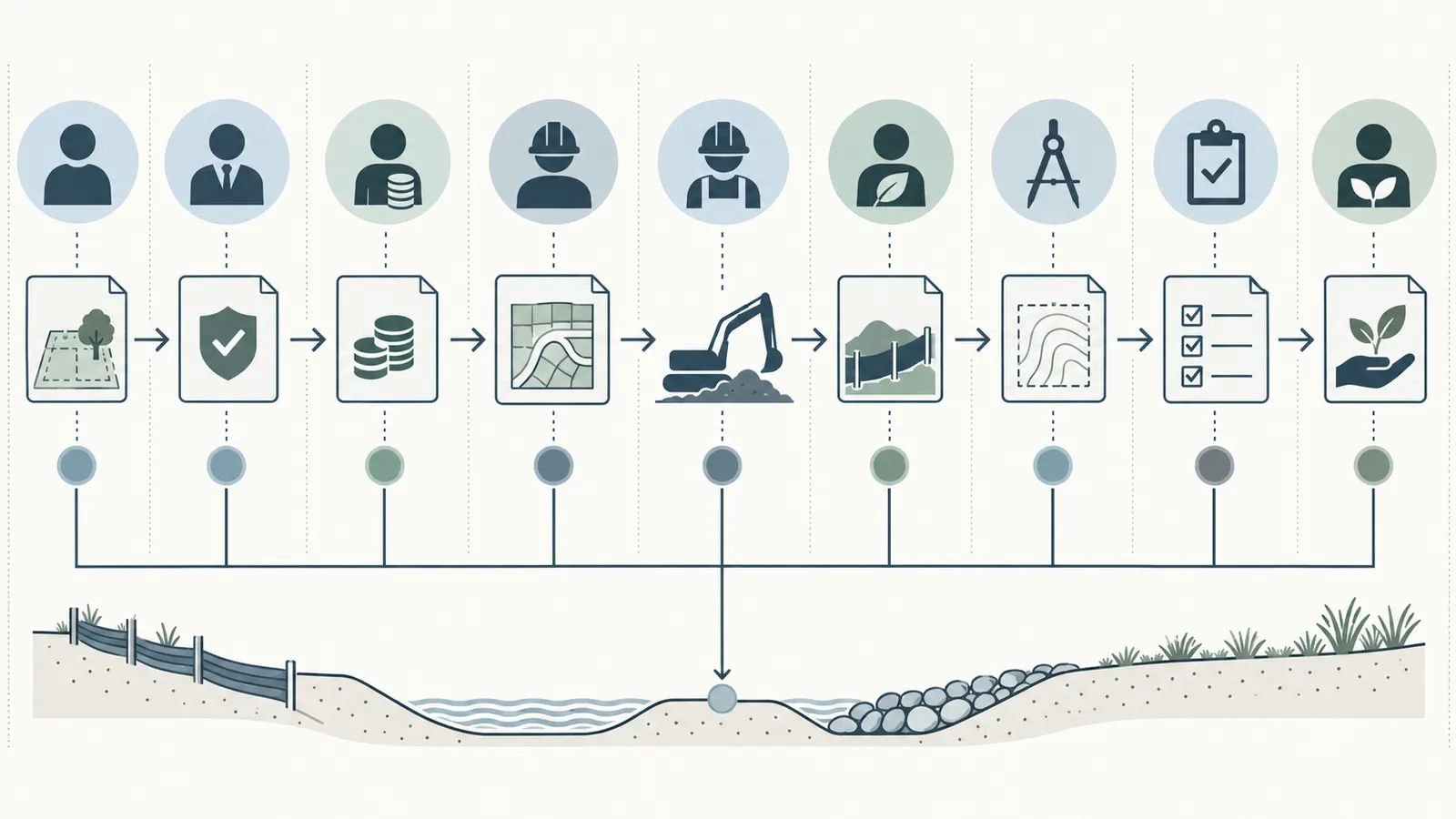
Responsibility is covered only when the public record and the construction agreement identify who controls the approval, who may sign or transfer it, who must install and maintain measures, and who must act when the site affects neighbors or public drainage. The owner, developer, builder, civil designer, responsible land disturber, and permittee can be different people, so write each role separately.
Use a role map instead of one “responsible party” field
Fill these roles from records, not assumptions:
| Role | What to record | Question to ask |
|---|---|---|
| Property owner at work start | Legal entity or person and parcel | Who owns the lot when clearing begins? |
| Permittee or certificate holder | Exact name on permit or coverage | Is this the entity authorized for the current work? |
| Financially responsible party | Exact name on ownership or responsibility form | Does it match the permittee where the program requires it? |
| Developer or common-plan holder | Entity that obtained subdivision approval | Has the developer retained any common-area duty? |
| Builder or owner/operator | Party directing daily construction | Who can stop work when controls fail? |
| Responsible land disturber | Name, certification or designation where required | Is the designation current and accepted by the authority? |
| Civil or environmental designer | Firm, contact, plan revision | Who can interpret or revise the approved plan? |
| Inspector or authority contact | Office and contact record | Who confirms start, inspection, modification, and closeout? |
| Maintenance holder | Named person, association, owner, or permittee | Who repairs a damaged measure after a rain or utility cut? |
Do not use “builder handles it” as a complete answer. A builder can have a contract duty to install controls while a public permit still names another permittee. A developer can remain responsible for roads or subdivision-wide facilities while the homeowner or builder is responsible for lot-specific controls. A civil engineer may design a measure without being responsible for the permit or daily maintenance. The register should preserve those distinctions.
Virginia: individual-lot coverage and maintenance are explicit checks
Virginia’s administrative rule requires an erosion and sediment control plan for a development and the buildings constructed within it. It also states that when individual lots or sections in a residential development are developed by different property owners, all land-disturbing activity related to building construction must be covered by a plan or agreement in lieu of a plan signed by the property owner. Read the current Virginia rule before relying on a developer’s common-plan statement.
That wording creates two homeowner checks. First, locate the document that covers the building construction on the individual lot, not only the original subdivision work. Second, identify the owner signature or authority-approved agreement if the chosen path uses one. This guide is not declaring that Virginia always requires a separate lot permit; the rule allows coverage by a plan or agreement and the authority determines the applicable record for the facts.
The same Virginia rule’s responsible-land-disturber provision requires the person responsible for carrying out the plan to provide the name of a certified individual in charge of and responsible for the land-disturbing activity, while allowing the authority to waive that certificate requirement for an agreement in lieu of a plan. It also requires maintenance responsibilities to be stated in the approved plan and requires erosion and sediment control structures and systems to be maintained, inspected, and repaired as needed. The practical register field is therefore not just “RLD: yes/no.” It is “name, certificate or designation, effective date if shown, scope, and authority acceptance.”
North Carolina: permittee identity and transfer require paperwork
North Carolina DEQ says the NCG01 permittee must be the same entity as the financially responsible party listed for the approved erosion and sedimentation control plan. DEQ also says the application cannot be signed by a consultant or someone outside the permittee organization. The North Carolina DEQ permit program page is the source for that identity check.
For a homeowner, the implication is straightforward: obtain the actual financial-responsibility or ownership form and compare its name with the certificate of coverage. If the seller says the builder is responsible but the public record names the developer, ask the authority whether the builder is an operator, a contractor, a new permittee, or simply a private subcontractor. Those labels may change who can sign a modification, pay fees, request termination, or transfer coverage.
North Carolina DEQ also describes a process for a purchased project with active erosion and sedimentation control plans. The new owner may request a transfer after obtaining updated E&SC documents from the issuing authority and completing a new financial responsibility/ownership form. Alternatively, the new owner may transfer the E&SC plan and obtain a new certificate of coverage, after which the previous owner submits the termination filing with the new certificate as support. See DEQ’s transfer and termination instructions.
The important wording is “may request,” not “automatically owns the permit after closing.” Put the transfer step, responsible person, deadline, and evidence into the purchase and builder sequence. A private contract can require the seller or developer to cooperate, but the issuing authority decides whether the public record has been updated.
South Carolina and Greenville County: an active subdivision permit still carries lot duties
Greenville County’s August 2024 single-family standards say a lot in a subdivision platted after 2003 may be covered under an active subdivision permit. The same passage requires construction to comply with erosion-control plans for individual lots shown on the subdivision stormwater management and sediment-control plan, with BMPs installed and maintained as described. It warns that failure can lead to a stop-work order and notice of violation, and that continuing off-site impacts can lead to a land-disturbance grading permit. Read the Greenville County standards.
“May be covered” is the operational phrase. The homeowner still needs the active permit identifier, the subdivision plan, the individual-lot plan or applicable typical lot detail, and a current response from Greenville County Land Development Division if the records conflict or the proposed work differs. This guide does not interpret South Carolina title, permit transfer, or subdivision declarations; it tells you what to verify.
Greenville County’s standards also assign the permit holder responsibility for correct installation and ongoing maintenance of lot-specific devices, inspections, inlet protection, a stabilized construction entrance, subcontractor and delivery-person stormwater actions, and off-site impacts. They state that inspections are required within 24 hours after a rain event of at least one-half inch and that controls remain until the site is vegetated or otherwise stabilized. Read the Greenville County standards for those local duties and triggers. That makes the role map essential: a builder may be doing the work, but the permit holder must know who is responding when a delivery truck tracks mud into the road or a utility crew damages a control.
Richmond, Virginia: subdivision status does not replace a local single-family permit
The City of Richmond provides a useful counterexample to any broad assumption that subdivision coverage handles every house. Richmond states that single-family dwellings disturbing at least 4,000 square feet, or at least 2,500 square feet in a Chesapeake Bay Protection Area, require a separate Richmond Erosion & Stormwater Management Program permit whether inside or outside a common plan of development. The city also states that a building permit does not grant permission to construct a house. Use Richmond’s stormwater permitting page for the city-specific rule.
Richmond’s stated single-family submittal includes a VESMP application, responsible land disturber form and certification, and a small site plan showing the dwelling, adjacent streets and parcels, limits of disturbance, silt fence, and construction entrance. The city also describes an agreement-in-lieu path for eligible single-family dwellings, with a small site plan and bond; Richmond’s stormwater permitting page says that path can replace a complete set of civil engineering plans. The linked Richmond AILP form requires a performance guarantee and makes its release contingent on the Program Administrator’s final inspection and stabilization finding. A homeowner in Richmond should therefore ask the city which path applies instead of showing a developer’s subdivision approval to a building-permit counter and assuming the erosion issue is resolved.
Richmond also requires final-inspection verification before release of erosion and sediment control surety and says the owner must request the inspection. The city page identifies a 75% living-perennial-vegetation condition for final inspection. That is a local closeout example, not a Virginia-wide threshold. Record it only when your parcel is in the City of Richmond and the city confirms the applicable process.
Your next handoff is a written role confirmation: “For this lot and this disturbance, who is the permittee, who is the current owner/operator, who is the responsible land disturber, who maintains lot and common-area controls, and what action updates the record after sale?” Send the question to the authority and copy the seller or developer. Keep the answer with the plan, not only in email search.
How do the local examples change the answer? #
The local examples show that an approved subdivision can be a starting point in one jurisdiction, a component of a lot-specific package in another, and insufficient for a separate single-family permit in a city. Use the jurisdiction to choose the question, not to predict the result from a neighboring state.
Comparison matrix
| Place | What the source says | What a homeowner should verify | What not to infer |
|---|---|---|---|
| Virginia statewide | Building disturbance in a residential development must be covered; different-owner lots need a plan or agreement signed by the property owner; maintenance duty appears in the approved plan. Virginia’s erosion-control rule | Lot-specific coverage, owner signature or agreement, certified responsible person, maintenance language, current authority record. | That every small lot needs a standalone permit, or that one developer approval automatically covers every later owner. |
| Guilford County, North Carolina | A subdivision/common-plan homebuilding lot needs an approved erosion plan, grading permit, and NCG01 coverage. Guilford County’s residential-lot guidance | Approval, grading permit, NCG01 reference, lot number, plan limits, and local authority response. | That an outside-subdivision threshold applies inside a subdivision. |
| North Carolina DEQ | Common-plan acreage can bring smaller disturbances into construction-stormwater coverage; plan materials show numbered lots and LOD; purchased-project transfer has stated steps. DEQ’s construction-stormwater program and residential-plan materials | COC, FR/O, E&SC documents, LOD including staging/utilities, transfer or new-COC evidence, inspection/closeout. | That a deed or private assignment automatically updates coverage. |
| Greenville County, South Carolina | A post-2003 subdivision lot may be under an active subdivision permit, but individual-lot plans and BMP duties still apply. Greenville County’s residential standards | Active permit, individual-lot plan, BMP placement and maintenance, inspections, off-site impact response. | That “active subdivision permit” removes the lot holder’s practical duties or prevents a new grading permit requirement. |
| City of Richmond, Virginia | Single-family dwellings at stated local disturbance thresholds need a separate Richmond permit in or out of a subdivision; building permit alone is insufficient. Richmond’s stormwater permitting guidance | RESMP or AILP path, RLD form, small site plan, LOD, construction entrance, bond, final inspection. | That statewide Virginia lot treatment replaces Richmond’s local process. |
How to use the matrix without overgeneralizing
First, identify the authority that will inspect or issue the land-disturbance approval. It may be a county, city, state agency, delegated local program, or more than one authority. Second, use the source for that authority to identify the record names and threshold questions. Third, ask the authority to apply the rule to the parcel and proposed disturbance. A source can tell you what the program requires; it cannot decide from a web page whether your particular lot matches an approved plan.
The matrix intentionally separates “may be covered” from “must submit.” Greenville County’s wording illustrates why status must be confirmed. Guilford County’s wording illustrates why subdivision-lot work can have multiple required records. Richmond illustrates why a local permit can be separate even inside a common plan. Virginia illustrates why a plan’s maintenance and responsible-person fields belong in the register. North Carolina DEQ illustrates why a purchased-project handoff should be documented rather than assumed.
Common plan, common controls, and individual-lot work are different layers
Think in layers:
- Subdivision or common-plan layer: roads, mass grading, drainage facilities, common open space, overall sequence, and the developer’s original responsibility.
- Lot layer: house, foundation, driveway, utilities, septic or well area, individual-lot BMPs, and lot-specific stabilization.
- Off-site layer: street entrance, utility corridor, drainage outfall, neighboring easement, shared inlet, or disturbance outside the lot.
- Ownership layer: who owns and operates the work at each stage, who may sign, and who must transfer, modify, or close coverage.
- Closeout layer: final stabilization, inspection, release, transfer, or termination evidence.
One document can address several layers, but the register should not collapse them. A plan may cover the common plan and display individual-lot controls while the construction-stormwater certificate names a particular permittee. A city may require a local single-family permit even if the plat was approved as part of a subdivision. A homeowner may have a private contract for the builder to maintain BMPs while the public record imposes responsibility on a different permit holder.
The “yes, but” answers that need a second question
When someone says the lot is covered, respond with the matching follow-up:
| Statement | Follow-up that makes it verifiable |
|---|---|
| “The subdivision has an erosion permit.” | What is the permit number, current status, plan revision, and sheet where my lot appears? |
| “Your lot is in the plan.” | What lot number and limits of disturbance are shown, and do they include the current house and utilities? |
| “The builder handles erosion.” | Who is the public permittee and responsible land disturber, and what document authorizes the builder to act? |
| “The permit transfers at closing.” | What transfer or new-certificate form does the authority require, and who submits it? |
| “The building permit covers it.” | Does the land-disturbance authority confirm that in writing for this jurisdiction and disturbance? |
| “It is only a small lot.” | How is total common-plan disturbance calculated, and what local threshold or program applies? |
| “The lot is stabilized.” | Is there a final inspection or release record, and does your new house work reopen or expand the disturbance? |
This table is a conversation tool, not a substitute for the authority’s answer. Save the response as evidence in the register with the date, name, office, and records reviewed.
How do you run the subdivision coverage-and-responsibility register? #
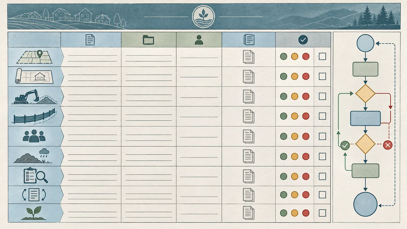
Run the register as a gated worksheet: every required field must be filled with a document reference or a written authority answer before the next action is released. The register is the original decision surface because it connects land identity, plan scope, public responsibility, construction timing, and closeout in one falsifiable record.
Register template
Copy this table into your project record and add sheet, page, revision, or portal references in the evidence column.
| Field | Required entry | Evidence to attach | Status rule |
|---|---|---|---|
| Jurisdiction | State, county, city, delegated program, and issuing office | Authority page, application instructions, contact record | Never write only “USA” or a state if a city/county program applies. |
| Parcel identity | Address, tax parcel, legal description, recorded plat book/page or recording reference | Current plat, deed or seller record, tax record | Hold if identifiers conflict. Do not cure a mismatch by editing the spreadsheet. |
| Lot identity | Subdivision name, phase, lot number, replat or amendment | Recorded plat and plan lot table | Hold if plan says a different lot or phase. |
| Plan identity | Title, approval number, approval date, revision, sheet list | Approved plan and letter | Hold if only an unapproved draft is provided. |
| Coverage identity | Permit, certificate, NCG01 or local reference, active/expired status | Permit record, certificate, authority portal or letter | Hold if status cannot be confirmed. |
| Disturbance boundary | LOD area in square feet/acres and mapped polygon | Approved LOD, current site/civil plan, overlay | Hold if house, utilities, access, staging, or off-site work falls outside. |
| Plan assumptions | Slope, grade, water, wetlands, soils, discharge, stabilization, staging assumptions | Survey, site review, environmental record, plan notes | Escalate assumptions a homeowner cannot safely verify. |
| Property owner at start | Name and expected ownership date | Contract, deed timing, authority form | Hold transfer question if owner changes before work. |
| Permittee | Exact entity and public record | Permit or COC | Do not replace with “builder” without authority confirmation. |
| Financially responsible party | Exact entity and form date | FR/O or local equivalent | In North Carolina, compare to NCG01 permittee. |
| Responsible land disturber | Name, certification/designation, scope | RLD form or local equivalent | Hold if required designation is missing or stale. |
| Developer/common-plan duty | Common-area and subdivision obligations | Agreement, plan notes, developer confirmation | Separate road/common BMPs from lot BMPs. |
| Builder/operator duty | Installation, inspections, repairs, notices | Contract exhibit and authority response | Private contract does not itself prove public transfer. |
| Maintenance duty | Who maintains each control and until what condition | Plan maintenance statement, permit, local standard | Hold if no person can act after a storm or utility cut. |
| Start condition | Preconstruction meeting, start notice, bond, fee, or authority release | Notice, meeting record, receipt, letter | No clearing while a stated precondition is open. |
| Inspection method | Authority inspections, self-inspection frequency, rain trigger, records | Local rules, forms, inspection log | Assign a named person and backup. |
| Change trigger | Design, access, grading, utility, slope, water, staging changes | Change log and designer review | Recheck coverage before approving the field change. |
| Violation status | Notices, stop-work orders, unresolved corrections | Authority file and seller/developer records | Hold until authority documents release or correction. |
| Closeout or transfer | Final inspection, stabilization, release, transfer, new COC, or e-NOT | Final report, letter, portal confirmation | Do not mark complete from a verbal assurance. |
| Authority confirmation | Date, office, name, exact question and response | Email or letter attached to register | This is the strongest resolution for ambiguity. |
Scoring the register without pretending it is an official permit test
You may use a simple internal status label, but do not present it as a legal score. A useful label is:
- Green — matched: every applicable identity, boundary, responsibility, timing, and handoff field has document evidence or written authority confirmation.
- Amber — conditional: the authority has identified a path, but one action remains, such as an owner update, transfer application, bond, revised lot exhibit, responsible-person designation, or preconstruction meeting.
- Red — hold: lot or phase does not match, coverage is expired or unknown, disturbance exceeds the plan, the responsible party is unclear, a violation is unresolved, or the authority has not confirmed an essential step.
The label is a project-control device. It does not make the work lawful, safe, or approved. A green register still requires the site to be managed as the plan states. A red register does not mean the project cannot proceed; it means the next decision is to correct the record or obtain a new approval before disturbance.
Worked register example
The following example is illustrative and modeled. It is not a real parcel, inspection, interview, measurement, or authority response.
Assume a buyer is considering Lot 18 in Phase 2 of “Cedar Ridge.” The seller provides a recorded plat, a 2023 subdivision erosion plan, a 2024 builder email, and a plan sheet labeled “Typical Lot B.” The proposed house has a basement, a 14-foot-wide driveway, a septic area behind the house, a utility trench to the street, and a temporary stone entrance. The plan cover says “Cedar Ridge Phase 1,” and the lot table contains lots 1–12. The buyer’s current design is therefore outside the visible plan match even though the seller says the development is permitted.
The register should not be marked amber merely because the difference looks administrative. The identity and lot fields are red because Phase 2 and Lot 18 are missing. The LOD field is also red because the current driveway and septic area are not shown. The responsibility field is unknown because the buyer has not seen the permit or coverage record. The next action is a written request to the issuing authority and seller for Phase 2 records, not a price negotiation with the excavator.
Suppose the authority then supplies a Phase 2 plan with numbered lots and a current active permit, but the plan’s LOD stops at the lot frontage and does not show the septic area. The register changes only partway: identity and coverage may become green; disturbance remains red; the plan designer must confirm the septic disturbance or submit a revision. If the owner will change before work begins, the transfer field remains amber until the authority accepts the required change.
Suppose instead that the authority confirms the Phase 2 plan covers Lot 18 and the septic area, but the driveway is in a shared access easement maintained by the developer and its disturbance is under a separate common-area approval. The register should record two plan identities and two responsible roles. The homeowner’s lot work can be green only when the shared-access handoff is also resolved. “My lot is covered” cannot erase disturbance on an easement.
Record exact questions for the authority
A precise email is easier to answer than “Are we permitted?” Use a subject such as “Lot 18, Cedar Ridge Phase 2 — verify erosion plan and land-disturbance coverage before house construction.” Attach the recorded plat with the lot highlighted and a one-page proposed disturbance exhibit. Ask:
- Which approved plan, agreement, permit, or certificate covers this lot and proposed disturbance?
- Does the record identify the subdivision phase and lot number shown on the attachment?
- Do the proposed house, driveway, utility routes, septic or well work, staging, stockpiles, and access fall inside the approved limits of disturbance?
- What is the current status and expiration of the permit or coverage?
- Who is the current permittee, financially responsible party, owner/operator, and responsible land disturber?
- Before closing or sitework, is a transfer, new certificate, revised FR/O, owner signature, agreement, bond, start notice, or preconstruction meeting required?
- Who must inspect and maintain lot-specific and shared controls, and what triggers an inspection?
- What document proves final stabilization, closeout, release, or transfer when the work is finished?
Ask for a written response or a reference to the exact public record. If the authority will not decide by email, ask for the correct intake process and record the call date, office, person, question, and promised follow-up. Do not change an unanswered field to green.
What must happen before closing, clearing, and excavation? #
Sequence the transaction and the work so that ownership, design, public coverage, and control installation are resolved before irreversible disturbance. The safest release point is not “the builder has a plan”; it is “the authority-required record and handoff are complete for the actual disturbance.”
Before signing or releasing a purchase contingency
Make the seller or developer provide the record set early enough for civil review. Put the following in the project’s written conditions, subject to local legal advice:
- the exact plan, permit, certificate, and plan revision to be delivered;
- the lot and phase match to the recorded plat;
- the active-status verification date;
- a duty to cooperate with authority-required transfer, amendment, or new-coverage filings;
- a duty to disclose notices, violations, stop-work orders, unpaid fees, expired coverage, or unresolved corrections;
- a requirement that the proposed house disturbance be reviewed against the approved LOD;
- responsibility for common-area, street, shared-inlet, or easement controls;
- the record to be delivered at closing, such as authority confirmation or accepted transfer evidence;
- a condition that no clearing, grading, excavation, or material delivery begins until the register reaches the required internal status.
This is not a legal clause and does not tell you what your contract means. Have a local real-estate attorney review conditions affecting title, risk allocation, closing, or remedies. The point is to make the document handoff visible early, so an unresolved public-record issue does not surface when an excavator is already mobilized.
Before awarding the builder or site contractor
Give bidders the same plan set, LOD, site constraints, inspection duties, and responsibility matrix. Ask each bidder to identify exclusions and assumptions:
- Does the price include construction entrance, perimeter controls, inlet protection, stockpile controls, washout, repair after utility work, and final stabilization?
- Who supplies and installs controls before first delivery or excavation?
- Who inspects after rain and documents the condition?
- Who can stop work and who pays for corrective work after off-site sediment leaves the site?
- Does the bid include permit fees, bonds, plan revisions, transfer fees, inspection fees, and authority meetings, or are they allowances?
- What happens if the approved LOD conflicts with the current house plan?
- Does the builder expect the owner, developer, or civil professional to be the permittee or responsible land disturber?
- Who maintains controls during subcontractor work and utility installation?
- What evidence will be delivered at closeout?
Greenville County’s standards illustrate why these details belong in a scope. The permit holder is described as responsible for subcontractor and delivery-person actions, off-site impacts, construction entrance maintenance, and repair of BMPs. The Greenville standards are local, but the scope lesson travels: put control responsibility in the contract, then reconcile it with the public permit record.
Before the first delivery or clearing pass
Confirm the authority’s stated pre-work steps. Depending on the jurisdiction and project, that may include a permit issuance, accepted plan, coverage, transfer, owner signature, responsible land-disturber designation, bond or surety, preconstruction meeting, start notice, construction entrance, installed perimeter controls, or inspection request. The authority’s list controls; do not assemble a generic checklist and assume it replaces the local one.
The field release should be a short written instruction naming:
- the parcel and plan revision;
- the approved disturbance boundary;
- the person authorized to direct site work;
- the person responsible for inspections and repairs;
- the conditions that must be in place before machinery enters;
- the phone or portal process for a change or incident;
- the stop-work triggers.
The homeowner can inspect visible documentation and photograph installed controls from a safe location. The homeowner should not direct the design of a sediment basin, enter an excavation, work around heavy equipment, alter a drainage outlet, or install a control in a concentrated-flow path without qualified direction. A competent contractor or qualified professional must handle field work that presents fall, struck-by, excavation, contaminated runoff, utility, or unstable-slope hazards.
Construction sequence: a practical handoff map
| Stage | Owner or buyer action | Professional or contractor action | Evidence to retain | Release condition |
|---|---|---|---|---|
| Record review | Provide plat and current house/site concept | Overlay proposed disturbance and review assumptions | Marked-up plat and comments | LOD match or documented revision path |
| Authority confirmation | Ask exact lot/coverage/responsibility questions | Respond to technical questions and prepare revisions | Written authority response | Required path identified |
| Ownership change | Notify seller, authority, and closing team | Submit accepted transfer/new coverage documents | Filing receipt and acceptance | Public record updated or authority-approved condition |
| Builder award | Share same scope and exclusions | Price controls, inspections, repair, stabilization, closeout | Signed responsibility matrix | No undefined control duty |
| Pre-work | Confirm permit/coverage/start conditions | Install controls and attend meeting | Photos, meeting note, notice, receipt | Authority and contractor agree work may start |
| Earthwork | Monitor that actual work follows boundary | Inspect, maintain, correct, document | Inspection log and correction records | No unaddressed off-site impact |
| Design change | Stop release of changed area | Ask designer/authority whether modification is needed | Change log, revised sheet, approval | New scope is accepted before disturbance |
| Stabilization | Request final review when eligible | Complete stabilization and closeout package | Final inspection, release, transfer, or termination | Register closed with evidence |
The table is a management aid, not an official inspection protocol. It deliberately places the owner, authority, designer, and contractor in distinct columns because a handoff is where ambiguity becomes a field problem.
If the developer wants you to start before the transfer
Ask for the written authority rule that allows it, the exact responsible party during the interim, and the record that prevents a gap. If the answer is only a private indemnity, recognize what that document cannot do: it may allocate financial risk between private parties, but it does not necessarily change the public permittee, coverage status, authority inspection rights, or stop-work exposure.
In North Carolina, DEQ describes active purchased-project coverage as requiring a transfer or a new certificate path, with updated plan documents and financial-responsibility information. The DEQ process page should be your starting point for a North Carolina transaction. Ask the local issuing program how the state coverage and local erosion plan connect. In another jurisdiction, use that authority’s process instead.
The safest next step is a pre-work hold that names exactly what is missing and who must supply it. A hold is not a refusal to build. It is a controlled pause before land disturbance makes the consequences harder to reverse.
How do you verify controls, changes, and closeout? #
Verify the site throughout the disturbance, not just at plan approval, because controls can be damaged, conditions can change, and a final house design may expand the work beyond the approved boundary. The verification record should show what was observed, who inspected, what changed, what was corrected, and when the authority accepted the next step.
What a homeowner can safely verify
From a safe accessible location, a homeowner can compare the visible work with the approved exhibit and ask whether:
- the construction entrance is where the plan shows it and prevents tracking onto the road;
- perimeter and inlet controls are installed before excavation or deliveries where required;
- material, soil, fuel, concrete washout, and equipment are staged within the allowed area;
- controls remain intact after rain and after utility or grading work;
- sediment or muddy water is leaving the site, entering a road, adjacent lot, storm drain, stream, or wetland;
- the contractor’s inspection log identifies the date, conditions, finding, correction, and person responsible;
- the current work remains inside the LOD;
- stabilization is progressing where work pauses or finishes;
- any authority notice, correction, or stop-work instruction is posted and resolved.
Do not use a phone photograph to certify slope stability, wetland boundaries, structural safety, underground utility clearance, or the adequacy of an engineered control. Photos are useful chronology, not professional sign-off. Do not walk into an excavation or stand below a stockpile or unstable slope. Call the designated professional or authority when a hazard or discharge is suspected.
Inspections and rain triggers are jurisdiction-specific
North Carolina DEQ publishes self-inspection and self-monitoring forms for lots in its E&SC downloads and forms materials. The North Carolina construction-stormwater program instructions identify a final-inspection path before an electronic Notice of Termination when a project is released from its approved plan and state that annual invoices continue until coverage is formally terminated. Record the inspection form and the termination confirmation where the North Carolina process applies.
Greenville County’s residential standards state that the permit holder must inspect within 24 hours after a rain event of at least one-half inch and correct problems immediately. The same document says BMPs remain until the site is vegetated or otherwise stabilized. Greenville County’s standards provide those local instructions. Do not copy that rain trigger into Virginia, North Carolina, or another South Carolina county without confirmation.
Virginia’s rule states that erosion and sediment control systems must be maintained, inspected, and repaired as needed, with the maintenance responsibility described in the approved plan. Virginia’s Administrative Code provision is therefore a reason to locate the plan’s maintenance language, not a reason to invent an inspection frequency.
Treat design changes as coverage questions
The following changes should trigger a register review before the work occurs:
- house moves or grows;
- basement depth, retaining wall, or foundation excavation changes;
- driveway width, grade, or connection changes;
- septic, well, sewer, drainage, or utility route changes;
- tree clearing, mass grading, soil export, borrow, or stockpile location changes;
- access moves onto a neighbor’s lot, easement, road right of way, or common area;
- a control is relocated because of rock, groundwater, a utility, or construction access;
- the project is phased differently from the approved sequence;
- a pause leaves bare soil exposed through a new season;
- a lot is sold, builder changes, or a developer turns over a common facility.
Use a change note with five fields: what changed, square feet and location affected, which plan sheet changes, who reviewed it, and what written authority action is required. If the civil professional says no plan change is needed, keep that response. If the authority says a modification, transfer, new permit, or new certificate is needed, do not let the field crew proceed on the old approval.
Common failure cases and the correct next action
| Failure case | Why it is not resolved by a verbal promise | Safest next action |
|---|---|---|
| Plan shows Phase 1; lot is Phase 2 | A phase mismatch can change the approved land area, drainage, and permittee | Obtain Phase 2 plan and authority confirmation; hold work. |
| Lot number matches but house footprint is outside LOD | The control design may not cover the new runoff or soil exposure | Have the civil professional overlay the design and seek modification if needed. |
| Developer’s permit is active but owner is changing | Public responsibility and transfer steps may not follow the deed automatically | Ask authority for transfer/new-coverage process and acceptance evidence. |
| Builder says owner signs later | A missing owner or FR/O signature can prevent application acceptance in programs with identity requirements | Identify the current permittee and required signer before work. |
| Building permit was issued | Building approval and land-disturbance approval can be separate | Confirm with the land-disturbance authority; do not release clearing from building permit alone. |
| “It is under one acre” | Common-plan rules or local thresholds can cover smaller lot disturbances | Compute the correct common-plan scope and ask the authority which threshold applies. |
| Silt fence is installed but mud reaches the road | A visible measure can be misplaced, damaged, or insufficient for the flow path | Stop the contributing work, notify the responsible person, correct immediately, document. |
| Utility crew cuts a control | The disturbance and control condition changed during the handoff | Repair or reinstall under the permittee’s direction and record the event. |
| Final grading is complete but closeout is missing | A stabilized-looking site may still have open coverage, fees, or inspection obligations | Request final inspection/release/termination records and keep coverage status open. |
| Plan is old but no one knows if it expired | Approval history and current active status are separate facts | Ask issuing authority for current status and applicable renewal or reapproval step. |
These branches are designed to prevent a common category error: treating an observable field condition as proof of an administrative status, or treating an administrative record as proof that the field work is adequate.
Closeout is a handoff, not the day controls disappear
Closeout should answer four different questions:
- Has disturbed soil been permanently stabilized to the authority’s standard?
- Has an authority inspector or authorized reviewer accepted the final condition where required?
- Has responsibility for permanent stormwater facilities or maintenance been transferred or recorded?
- Has active coverage been modified, transferred, released, or terminated, with proof?
Richmond’s process illustrates this separation. The city says written final-inspection verification is required before a portion of the erosion and sediment control surety can be released, and the owner must request the inspection. The city’s page also states a 75% living-perennial-vegetation condition for final inspection. Richmond’s stormwater management guidance supports recording final inspection and surety evidence separately from a building inspection.
North Carolina’s construction-stormwater program likewise distinguishes release from approved plan and electronic termination of the certificate of coverage. DEQ says an electronic Notice of Termination is required when the project has been released through a final inspection report, and annual invoices continue until coverage is formally terminated. That means the homeowner should not mark “closed” from a final-seeding photograph alone.
If a new owner or builder takes responsibility before closeout, keep both the outgoing and incoming records. A transfer is not the same as termination; a new certificate is not the same as a final inspection; a final inspection is not necessarily the same as permanent maintenance acceptance. The register should name each document and date.
Hazard boundary for homeowners
Erosion work often sits beside excavation, machinery, temporary slopes, overhead or buried utilities, public roads, contaminated runoff, and water. A homeowner can collect documents, ask questions, observe from a safe location, and maintain a decision log. Assign the following to qualified local professionals and follow the authority’s safety rules:
- survey, boundary, elevation, and construction-staking work;
- wetland, stream, floodplain, or environmental delineation;
- civil design, drainage calculations, sediment basin, diversion, outlet, and slope decisions;
- excavation, shoring, trenching, heavy-equipment operation, and utility locating;
- installation or repair of controls where a fall, struck-by, engulfment, electrical, or unstable-ground hazard exists;
- interpretation of a permit’s legal effect, title obligations, easements, declarations, or private remedies;
- authority submissions and professional certifications that require a licensed or designated signer.
This guide cannot remotely determine whether soil will erode, whether a drainage route is safe, whether a wall is stable, or whether a permit covers an unshown condition. If a contractor is about to disturb an area not shown in the approved documents, the safe response is to pause that area and get the plan and authority question resolved.
When should you release the lot, correct the record, or obtain new coverage? #
Release the project only when the register is green for the applicable jurisdiction and the authority-required handoff is documented; correct the record when a field is conditionally resolvable; obtain new or modified coverage when the lot, disturbance, responsible party, or active status does not match. The decision is about evidence, not confidence.
Release: all critical matches are closed
You can recommend a controlled release to the owner, builder, and civil professional when the file contains:
- recorded plat and plan lot/phase match;
- current parcel and owner information;
- approved plan and revision identified;
- current permit or coverage status confirmed;
- proposed house, driveway, utilities, access, staging, and off-site work inside the approved scope or separately addressed;
- required assumptions checked by the appropriate professional;
- permittee, financial responsibility, owner/operator, and responsible land disturber identified;
- maintenance and inspection duties assigned;
- transfer, agreement, bond, fee, start notice, or preconstruction conditions completed;
- no unresolved violation or stop-work issue blocking work;
- written authority response or public record supporting the ambiguous points;
- a change-control and closeout plan with named people.
“Release” should still be limited. It can mean “release the approved disturbance under the stated conditions,” not “the site is safe for any construction method.” Put the approved plan and LOD in the builder’s field package and require the builder to escalate changes.
Correct: the path is known but one handoff remains
Correction is appropriate when the authority or qualified designer has identified a straightforward missing action, such as a revised lot exhibit, current plan set, owner signature, accepted RLD form, transfer application, new FR/O form, bond, inspection request, or construction entrance detail. Mark the register amber and write the exact completion evidence required.
Do not let an amber field silently become green because a deadline is near. If the correction changes who is permitted to sign or who is responsible for maintenance, wait for acceptance. If the correction changes the ground area, wait for the approved plan or written direction applicable to the work.
Obtain new or modified coverage: the existing approval does not fit
Obtain a new or modified approval when the authority says the current plan does not cover the lot or proposed work; the lot is in a different phase; the LOD excludes material work; the project has a new common-plan relationship; the permit or certificate is expired or terminated; a sale requires transfer or a new certificate; a water, slope, discharge, staging, or access condition defeats the plan assumptions; or a local rule requires a separate single-family process.
In Richmond, for example, the city’s stated separate single-family permit requirement applies at its local disturbance thresholds both inside and outside a common plan. In Guilford County, the county says a subdivision lot needs an approved erosion plan, grading permit, and NCG01 coverage in its residential-lot guidance. In Greenville County, an active subdivision permit may cover a post-2003 lot, but individual-lot plans and BMP duties still apply under the county’s residential standards. These are different answers because the authorities and program structures are different.
A short decision tree
Use this order:
- Does the recorded plat and public plan identify the same lot and phase? If no, hold and obtain the correct record.
- Does the approved LOD contain the real disturbance? If no or unknown, hold the changed area and obtain an overlay or revision.
- Is the permit or coverage current and applicable to this work? If no or unknown, ask the issuing authority for status and the required new path.
- Does the responsible-party chain match the current ownership and operator? If no, complete the transfer, new certificate, owner form, or other local action.
- Are pre-work conditions, controls, inspections, and maintenance duties assigned? If no, complete the handoff before delivery or excavation.
- Has the authority answered the jurisdiction-specific ambiguity? If no, preserve the hold; if yes, attach the response.
- Has work stayed inside the approved scope? If no, pause the changed area and re-review.
- At the end, is there final stabilization and closeout evidence? If no, keep the register open.
This tree is intentionally conservative because the cost of resolving a document gap before earthwork is usually lower than explaining an unauthorized or uncontrolled discharge after the fact. It does not predict fines, liability, permit outcomes, title rights, or contractor remedies.
The next decision after verification
After the register is complete, make one of three decisions in writing: release this defined work, hold and correct these named fields, or change the approval path before work. Attach the register to the builder’s scope and the closing file. Tell the contractor which actions are prohibited until the status changes.
The homeowner’s final question should be specific: “What must be true before the next irreversible action?” Before closing, it may be authority confirmation and transfer cooperation. Before clearing, it may be the accepted plan, coverage, RLD, entrance, perimeter controls, and start condition. Before excavation, it may be a field verification that the work stays inside the LOD. Before closeout, it may be final inspection, stabilization, maintenance transfer, and termination or release evidence.
That sequence turns a vague subdivision promise into an auditable project decision. It also keeps the limits honest: a document match does not replace a survey, civil design, inspection, or local authority determination, but a missing match is enough reason to pause and ask for one.
Cite this guide
Brictale. “Does a subdivision erosion-control plan cover your vacant lot home build?.” Published 2026-09-26; updated 2026-09-26.
https://brictale.com/build/land/verify-subdivision-erosion-control-coverage-before-building · Read the Markdown version
Original contribution: Subdivision coverage-and-responsibility register. A record-matching worksheet that tests whether the specific vacant lot and the planned house disturbance are covered, and names the person who must maintain that coverage.
Sources and scope
Evidence behind this page
- Virginia requires an erosion and sediment control plan for development and the buildings constructed within it, and when different property owners develop individual residential lots, building-related land disturbance must be covered by an approved plan or an agreement in lieu of a plan signed by the property owner.
9VAC25-875-550. Erosion and sediment control plan requirements
Virginia Administrative Code, Virginia erosion and stormwater management regulation; applies to the stated Virginia plan and individual-lot provisions, not nationwide construction or title questions.
Accessed · Link to this claim - In Virginia, land disturbance under 10,000 square feet on an individual residential lot is not exempt when total land disturbance in the residential development is at least 10,000 square feet.
9VAC25-875-550. Erosion and sediment control plan requirements
Virginia Administrative Code threshold interaction for an individual residential lot within a larger development; do not apply it to another state or local program.
Accessed · Link to this claim - Virginia requires erosion and sediment control structures and systems to be maintained, inspected, and repaired as needed, with maintenance responsibilities stated in the approved plan.
9VAC25-875-550. Erosion and sediment control plan requirements
Virginia Administrative Code maintenance requirement; it supports checking the approved plan for a named duty, not assuming the homeowner or builder is responsible everywhere.
Accessed · Link to this claim - Virginia requires the person responsible for carrying out the land-disturbing activity to provide the name of a certified responsible land disturber to the VESCP or VESMP authority, but the authority may waive that certificate requirement for an agreement in lieu of a plan; for individual lots developed by different property owners, building-related disturbance must be covered by a plan or agreement in lieu signed by the property owner.
9VAC25-875-550. Erosion and sediment control plan requirements
Virginia Administrative Code subsections B and C; applies to Virginia's VESCP or VESMP process and its stated authority exception, not to another state or a conclusion about a specific permit.
Accessed · Link to this claim - Guilford County, North Carolina states that a homebuilding lot within a subdivision or common plan of development must have an approved erosion control plan, a grading permit, and coverage under NCG01.
Residential Lot Erosion and Sediment Control
Guilford County, North Carolina local guidance for residential lots; the outside-subdivision comparison on the same page is not a national rule.
Accessed · Link to this claim - North Carolina DEQ's sample plan conditions require a subdivision plat or plan showing numbered lots and the limits of disturbance; the limits can include lots, access to measures, staging areas, and utilities extending off site.
North Carolina DEQ sample-plan guidance and stated assumptions for basic residential lots; it demonstrates the records to inspect and does not guarantee that a sample plan fits a site.
Accessed · Link to this claim - North Carolina DEQ's sample E&SC plan for small residential lots assumes an individual and total disturbance of no more than 1.00 acre, a vicinity map showing project boundaries and site access, a finished or final-grade lot with no mass grading, disturbed slopes no steeper than 10 percent, no jurisdictional waters within 100 feet of the lots, no High-Quality Water Zone, no discharge into impaired waters, no on-site vehicle or equipment washing, no off-site material storage, waste disposal, or borrow areas, and permanent ground cover on all disturbed areas not built upon; DEQ may require a site-specific plan when those assumptions do not apply.
E&SC Downloads and Forms — Sample E&SC Plan Set for Small Residential Lots
North Carolina DEQ's sample-plan assumptions and reservation of site-specific review for basic residential lots; these are not a national threshold or a finding that any particular North Carolina lot qualifies.
Accessed · Link to this claim - North Carolina DEQ says the NCG01 permittee must be the same entity as the financially responsible party listed for the approved erosion and sedimentation control plan, and a consultant or person outside that organization cannot sign the application.
North Carolina NCG01 construction stormwater program; use this as a North Carolina permittee identity check, not a universal transfer rule.
Accessed · Link to this claim - North Carolina DEQ states that its NPDES construction stormwater program applies to construction disturbing one acre or more, or less than one acre when it is part of a larger common plan of development of that size.
North Carolina DEQ program description; the common-plan treatment is not a statement of every state's threshold or local permit process.
Accessed · Link to this claim - For a purchased North Carolina project with active erosion and sedimentation control plans, DEQ describes ownership transfer or obtaining a new certificate of coverage; transfer requires updated E&SC documents and a new financial responsibility/ownership form, while a new certificate is followed by the prior owner's termination filing.
North Carolina DEQ process for purchased projects with active coverage; it does not say that a sale automatically transfers any permit in every jurisdiction.
Accessed · Link to this claim - North Carolina DEQ provides self-inspection and self-monitoring forms for construction lots in its E&SC downloads and forms materials.
North Carolina DEQ forms library; it supports locating the applicable inspection records and does not establish a nationwide inspection form or frequency.
Accessed · Link to this claim - North Carolina DEQ says an electronic Notice of Termination is required when a project has been released from its approved plan through a final inspection report, and annual invoices continue until coverage is formally terminated.
North Carolina DEQ construction-stormwater closeout and billing process; it supports asking for release, termination, and invoice evidence, not a nationwide closeout checklist.
Accessed · Link to this claim - Greenville County, South Carolina says a lot in a subdivision platted after 2003 may be covered by an active subdivision permit, but construction must comply with the individual-lot erosion plans shown on the subdivision plan and required BMPs must be installed and maintained; an off-site impact can lead to a separate grading permit, stop-work order, and notice of violation.
Single Family Residential Erosion/Sediment Control Standards, revised August 2024
Greenville County, South Carolina residential standards; the booklet's subdivision date and active-permit language is local and does not establish a South Carolina-wide or national rule.
Accessed · Link to this claim - Greenville County assigns the permit holder responsibility for lot-specific device installation, maintenance, inspections, subcontractor and delivery-person stormwater actions, and off-site impacts; its standards require inspection within 24 hours after a rain event of at least one-half inch and maintenance until the site is stabilized.
Single Family Residential Erosion/Sediment Control Standards, revised August 2024
Greenville County, South Carolina standards for residential land disturbance; use the actual permit and current local instructions for a particular lot.
Accessed · Link to this claim - The City of Richmond, Virginia states that single-family dwellings disturbing at least 4,000 square feet, or at least 2,500 square feet in a Chesapeake Bay Protection Area, require a separate Richmond erosion and stormwater permit whether inside or outside a subdivision; a building permit alone does not grant permission to construct the house.
Stormwater Management: Obtaining a Land Disturbing Permit
City of Richmond, Virginia local process and thresholds; do not substitute them for Virginia statewide or another locality's requirements.
Accessed · Link to this claim - For Richmond single-family dwelling review, the city lists a VESMP application, responsible land disturber form and certification, and a small site plan showing the proposed dwelling, adjacent streets and parcels, limits of disturbance, silt fence, and construction entrance.
Stormwater Management: Obtaining a Land Disturbing Permit
City of Richmond, Virginia application checklist for single-family dwelling land disturbance; this is a local submission example, not a universal plan-set requirement.
Accessed · Link to this claim - Richmond's Agreement In Lieu of Plan form for a single-family residence requires a performance guarantee, states that the guarantee is conditioned on the approved agreement's requirements, and makes release contingent on the Program Administrator's final inspection and finding that 80% of the project site's vegetation is adequately stabilized.
Agreement In Lieu of an Erosion and Sediment Control Plan — Single Family Residence
The City of Richmond, Virginia one-page AILP form for a single-family residence; it supports the form's performance-guarantee and final-inspection language, not Richmond eligibility, a universal bond amount, Virginia statewide rules, or another locality's process.
Accessed · Link to this claim - Richmond states that written final-inspection verification is required before release of any portion of the erosion and sediment control surety, and that the owner is responsible for requesting the inspection; the city also uses a 75% living perennial vegetation condition for final inspection.
Stormwater Management: Obtaining a Land Disturbing Permit
City of Richmond, Virginia surety-release and final-inspection process; do not apply its vegetation threshold outside Richmond without confirmation.
Accessed · Link to this claim