How to Prepare Construction Staking and Benchmark Release Before Excavating a New Home
A homeowner release sequence for construction staking, benchmarks, corners, grading limits, utilities, permits and excavation handoff.
The short answer
Release excavation only when the surveyor has tied the current approved plan to identifiable horizontal and vertical control, the builder has verified corners, grading limits, access and utility responses, and the authority's permit or inspection gate is satisfied. A homeowner can document the handoff, photos and open questions; a licensed surveyor, engineer, builder and local authority must own the technical certifications and safety decisions.How to Prepare Construction Staking and Benchmark Release Before Excavating a New Home
Do not release a vacant lot for excavation because stakes are visible or a crew is available. Release it only when the current approved plan set is identified, a surveyor has tied the plan to identifiable horizontal and vertical control, the builder has checked the marked corners and grading limits, utilities and access are addressed, and the authority's permit or inspection gate is satisfied. The homeowner records the handoff; qualified professionals own survey, engineering and excavation safety decisions.
Compact originality brief
Current answers: local government pages explain individual staking, benchmark, permit and inspection requirements, while 811 guidance explains the public utility-locate request. Missing decision: those answers do not by themselves tell a homeowner whether this particular lot is ready for the first excavation operation, who must close each gap, or what record should stop a plan-revision, datum, utility or safety mismatch. Original contribution: the “Construction-staking release sheet: a plan-to-field handoff” connects each mark and gate to the approved plan, control, datum, responsible person, evidence and next handoff. How to check it: give one real project packet to another person, ask them to trace every mark and release condition, then change one input—such as the plan revision, benchmark status or utility response—and confirm that the sheet forces a new status rather than silently preserving “ready.”
For related homeowner planning and site-preparation decisions, continue through Brictale's homeowner blog. The blog is a navigation route, not a substitute for the actual authority, surveyor, engineer, utility owner or builder for this property.
The release decision: what “ready to excavate” means #
A site is ready for an excavation release only when every item that could change the location, elevation, legal permission or safe sequence of digging has a named owner and a verified record. “Ready” is therefore a controlled handoff, not a visual impression and not a promise that the soil will behave as expected.
For a new home, construction staking translates an approved design into marks that a builder can use in the field. The marks may identify property or work limits, the building footprint, reference lines, elevations, grading transitions, driveway limits and protected features. The benchmark supplies the vertical reference; horizontal control supplies the position. Neither is self-authenticating because a stake can be set from the wrong revision, read from the wrong datum, moved by a machine, or misunderstood by a crew.
Monterey County, California describes the core concept clearly in its local staking guidance: construction staking is a surveyor applying approved-plan data to the site to establish horizontal and vertical definition, with corners and grading cut/fill based on the benchmark shown on the plans. That is a Monterey County process description, not a national rule, but it is a useful model for the homeowner's question: can the marks on this lot be traced back to the same plan and control that the authority will inspect? Monterey County's staking guidance
The owner should separate four decisions that are often collapsed into “the survey is done.”
- Permission: Is the proposed work allowed to begin under the actual building, grading, erosion-control, access, environmental and inspection requirements for this property?
- Control: Can a qualified surveyor identify the horizontal and vertical reference used by the approved plans and reproduce the intended location and elevation?
- Field readiness: Are the corners, offsets, grading limits, driveway or construction access, protected features and utility conflicts visibly recorded and protected from ordinary site activity?
- Safety: Has the builder assigned excavation safety to a qualified competent person, and are the excavation plan, soil information, protective systems, equipment movements and weather response ready?
These are related but not interchangeable. A surveyor can set excellent stakes on a site where a grading permit is missing. A building permit can be issued while the builder has not received a useful benchmark description. A complete utility response can still leave private lines or service routes unresolved. A signed staking sketch cannot authorize a worker to enter an unprotected excavation.
The proposed release is best understood as a stop/go gate:
| Gate | Evidence to have before release | Responsible person | What the homeowner may verify | Stop condition |
|---|---|---|---|---|
| Plan identity | Approved plan title, sheet index, revision/date and permit record | Owner, designer or permit holder | Photograph or save the plan cover, revision cloud and permit card | Crew has a different revision or “latest” is verbal |
| Horizontal control | Surveyor's control description, property or project reference, corner and offset marks | Licensed land surveyor where required; surveyor directs the set | Match labels, orientation and photos to the record | No traceable control, conflicting corners or disturbed marks |
| Vertical control | Benchmark ID/description, elevation, vertical datum or project datum and units | Surveyor and civil engineer/designer | Record the mark, label, units and relation to finished-floor or grading elevations | Datum, units or benchmark description is absent or inconsistent |
| Work limits | Building corners, offsets, foundation or excavation limits, grading transitions, driveway/access and protected features | Surveyor, civil engineer/designer and builder | Walk the site with the plan and dated photos | A line or stake is interpreted rather than documented |
| Authority gate | Issued permit, inspection/pre-site requirement, grading and erosion conditions | Permit holder and local authority | Read the actual card and conditions; call the authority with questions | The jurisdiction requires a gate that has not occurred |
| Utilities | 811 ticket, responses, private-line plan and conflict resolution | Builder, utility locator and private utility owner | Record ticket, marks and unresolved lines | Brictale homeowner gate: any responder is missing, marks conflict, or private service is unknown |
| Safety and access | Excavation method, soil information, equipment route, weather plan and competent-person assignment | Builder and qualified safety lead | Confirm the builder has a plan and named contact | Someone proposes entry, undermining or machine work without the required controls |
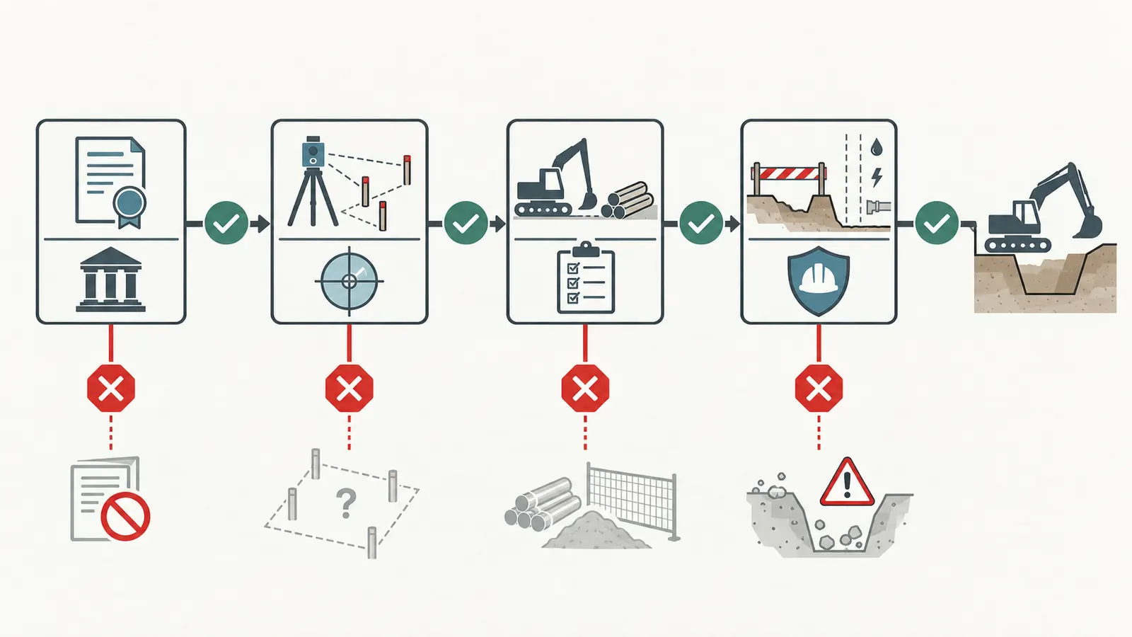
The homeowner's signature on a release sheet means “I have received and recorded the handoff,” not “I have certified the survey, soil, code or excavation.” That distinction protects the decision. If a field condition is unclear, the correct next action is to ask the responsible professional to resolve it before excavation, not to make the mark fit the machine's schedule.
What “benchmark release” actually releases
A benchmark release does not release a benchmark from professional responsibility. It releases the information needed for the next trade to use the benchmark without guessing. The record should state the mark's physical description, location, elevation, datum or local project reference, date checked, surveyor or crew, and what happens if the mark is disturbed.
For example, “BM near front walk” is not enough. A more useful record might say: “BM-1: chiseled square on the east face of the concrete utility vault, approximately 8 feet west of the proposed driveway centerline; elevation 500.00 feet in project vertical datum; surveyor to confirm on set date; do not remove; witness ties photographed.” The description is still not a survey certificate. It is a handoff record that tells the builder which object the surveyor intended and tells the homeowner what to photograph.
The word “release” can also mean different things to different parties. The surveyor may mean “my set is complete.” The builder may mean “I can mobilize the excavator.” The civil engineer may mean “the grading limits shown are consistent with the approved civil plan.” The inspector may mean “the required inspection can be requested.” Ask each person to use a distinct status:
- Set: marks and control were placed by the responsible professional.
- Received: the builder obtained the plan, staking information and instructions.
- Verified: the receiving party compared marks and documents, without re-certifying the survey.
- Conditionally released: work may proceed only within named limits and after a stated outstanding condition.
- Hold: excavation or a particular area must not begin.
Use “hold” whenever a person cannot say which plan, datum, boundary, elevation or permit condition governs. The cost of a second survey visit is usually easier to understand before a foundation is excavated than after concrete, shoring, haul-off and inspection scheduling have compounded the error. No national source can set the acceptable tolerance for your house footing or grading stake; the surveyor, approved plans, engineer and authority establish that project-specific requirement.
Gather the controlling documents before requesting stakes #
Request construction staking only after the approved plan set, permit conditions, survey basis, civil or grading information, soils inputs and access assumptions are assembled into one controlled issue. The surveyor can set marks from incomplete information, but the homeowner cannot later tell whether a mismatch came from the field, a superseded drawing or a missing prerequisite.
Start with a document register. It can be a simple table in the project folder, but every row should have a source, date, revision and owner. The register is valuable because different disciplines often use similar names for different files: a “site plan” may be an architectural sheet, a civil grading plan, a boundary survey or a permit exhibit. Ask which one controls each item.
| Document or input | Record these identifiers | Why it matters to staking | Owner to resolve a mismatch |
|---|---|---|---|
| Building permit and inspection card | Permit number, issue date, expiration or renewal terms, required inspections | Establishes whether building work may begin and which inspection is required | Permit holder and local authority |
| Approved architectural/site plan | Sheet number, revision/date, north arrow, dimensions, setbacks, footprint | Defines the intended building location and relationships to property or easements | Designer, architect or permit holder |
| Boundary or improvement survey | Survey date, surveyor, monuments, basis of bearings, legal description | Prevents a stake being mistaken for a property line or relying on an old monument | Licensed land surveyor |
| Civil/grading/drainage plan | Sheet, revision/date, existing/proposed grades, cut/fill limits, drainage and erosion notes | Determines where earthwork begins and what elevations must be maintained | Civil engineer, designer or grading professional |
| Soils or geotechnical report | Report date, lot/site, recommendations, special conditions | May affect excavation, over-excavation, subgrade, groundwater, fill and protective methods | Geotechnical engineer or engineer of record |
| Utility and access information | 811 ticket, utility responses, service records, driveway/road conditions | Prevents a building stake from being treated as a utility clearance or equipment route | Builder, utility owner and authority |
| Landscape, tree, wetland or environmental conditions | Approval, protected areas, fencing or flagging requirements | Identifies places where clearing, stockpiling or equipment travel is restricted | Authority, environmental professional or permit holder |
| Structural foundation plan | Foundation sheet, revision, wall lines, steps, thickened areas, retaining elements | Distinguishes the architectural footprint from the excavation or foundation geometry | Structural engineer and builder |
The City of Boulder, Colorado provides a useful local example of how much information can sit behind a “site plan.” Its residential guide says the survey must be stamped by a Colorado-licensed land surveyor, and it describes a survey-based site plan containing property lines, rights-of-way, easements, improvements, access, utilities and topography. It also warns that city mapping topography is general information and that property-specific topography and contours must come from a Colorado-licensed land surveyor. Those are Boulder requirements and examples; elsewhere, the responsible license, survey type and submittal list may differ. City of Boulder's residential permit guide
Use that example to ask a portable question: which site facts are permitted to come from a map, and which must be established by a surveyor on this property? Do not substitute an online parcel map, a real-estate listing, a satellite image or a prior owner's sketch for current field control. Those tools can help you orient yourself, but they cannot establish the location of a footing or the elevation at which soil may be removed.
Revision control is a field-safety input
Write the revision in plain language on the staking request. Include the entire issue, not only the sheet that seems relevant. A foundation plan can be unchanged while the civil sheet moves the house, the driveway, the stormwater feature or the finished floor. Conversely, a site plan can be unchanged while a structural revision changes a stepped foundation or retaining condition.
Ask the surveyor to confirm, before mobilizing:
- the plan set name and revision/date used;
- the sheets that control building corners, foundation geometry, grading, drainage and driveway/access;
- whether dimensions are taken to the property line, a survey monument, a grid or another control line;
- whether the benchmark and elevation reference are shown on the same approved issue;
- whether any field clarification, request for information or permit condition changes the stake request;
- how the surveyor will document stakes that cannot be set in the requested location;
- who must approve a change before the builder moves a mark.
An email that says “stake the house per plans” leaves too much unresolved. A controlled request may say, “Please stake the house and grading limits from architectural site plan A1.02 Rev. C dated June 4, civil plan C2.1 Rev. B dated June 4, and foundation plan S2.0 Rev. A dated May 28; use the benchmark and vertical reference identified on C2.1; include driveway entrance/exit and the no-disturb tree zone; call before setting if the property corners or benchmark cannot be found.” The point is not to write survey instructions that a homeowner invented. The point is to make the requested source documents and unresolved questions visible.
Prerequisites are different from inputs
An input is information the professional can use. A prerequisite is a condition without which the work should not be released. Examples:
- A soils report may be an input to excavation planning; an authority-required grading permit may be a prerequisite to mass excavation.
- A proposed driveway width is an input to access layout; an issued encroachment or access approval may be a prerequisite to mobilization.
- A utility map is an input; complete responses to the applicable 811 ticket and a plan for private lines are a prerequisite to digging.
- A survey drawing is an input; confirmation that the plan issue matches the permit and the requested field work is a prerequisite to relying on the stakes.
Make a separate “must be true before release” list. If a prerequisite is not met, do not bury it in a note that says “to be confirmed.” Give it a status, owner and decision date. A builder can then price or schedule the next action without pretending the condition is complete.
Convert the approved plan into field control #
The surveyor should be the person who converts the approved plans into property, building and elevation marks; the homeowner should verify the identity and record of the control, not recreate or certify the survey. The minimum useful handoff explains what each mark represents, which datum and units govern, how the marks were protected, and what the builder must do if any mark is lost or conflicts with the plan.
Construction staking is not one universal product. Depending on the project and authority, the request may include boundary or property-corner evidence, building corners, offset hubs or batter boards, reference lines, foundation or excavation limits, cut/fill stakes, finish-floor or pad elevations, driveway ends, drainage features, erosion limits and protected trees. The approved plans and local inspection card decide what is required. Never interpret a local example as a national minimum.
Monterey County, California's page illustrates the breadth of a local requirement: it identifies boundary markers, the benchmark, structure corners, grading limits and private driveway markers, and says the surveyor must mark the property boundaries, benchmark location, structure corners and grading limits for its inspection process. It also gives local stake-label examples such as a building type and compass orientation. Monterey County's construction-staking requirements
The homeowner should ask for a stake legend or field sketch, not merely a set of colored flags. A useful legend answers:
| Mark or notation | Question the field record must answer | Common mistake it prevents |
|---|---|---|
| Property corner or boundary monument | Is this a legal survey monument, a witness point or a construction reference? | Treating a temporary lath as the property line |
| Building corner | Is the mark the architectural corner, foundation face, footing edge, or an offset from it? | Excavating to a mark that represents an offset rather than the wall |
| Offset hub, nail or batter board | What line does it preserve, and what is the offset distance and direction? | Removing it because it appears outside the footprint |
| Benchmark | What physical object, elevation, datum, units and witness ties identify it? | Using a nearby nail or curb without permission |
| Cut/fill or grade stake | Is the number a cut, fill, target elevation, station, offset or slope note? | Reading “1.2” as an elevation rather than a cut depth |
| Driveway/access mark | Does it show the centerline, edges, curb cut, gate, turnaround or haul route? | Blocking the surveyor's access or placing equipment in a future drainage path |
| Protected-feature flag | What feature is protected, who approved the limit and what activity is prohibited? | Clearing or stockpiling outside the building envelope |
Labels must be legible to the crew that receives them. A homeowner does not need to decide the survey convention, but can ask the surveyor to explain it in the handoff. Photograph the label in context and close enough to read. Take a second photo showing the mark's relationship to a permanent feature. Record date, time, weather if relevant, and the plan issue. The purpose is future identification, not proof of survey accuracy.
Horizontal control: position is a chain, not a single corner
The house location is not adequately verified because four stakes form a rectangle. The surveyor's work must tie the rectangle to a recognized control basis and the approved site relationships. The homeowner's review should follow the chain:
- Where is north on the plan and in the field?
- What property or project control does the stake set reference?
- Which marks are legal boundary monuments, and which are temporary construction marks?
- Do the dimensions from the marked building or foundation lines to the relevant property lines, easements, access and protected features agree with the approved plan?
- Are offsets explained where an actual corner cannot be occupied?
- Are the excavation limits wider than the building footprint, and if so, who approved that limit and why?
Do not use a tape measure from a fence, curb or tree as a legal boundary check unless the surveyor has identified that feature as a valid control. Fences can be old or encroaching, curbs can be reconstructed, and trees can grow or be removed. The homeowner can compare visual relationships and written dimensions; a surveyor must resolve a boundary or control conflict.
An offset is especially easy to misunderstand. If the surveyor places a hub 5 feet north of a building corner so the excavator can preserve it, the hub is not the corner. The sheet or stake should say what it controls and the offset. If the excavator removes soil up to the hub, the building could be shifted by the offset distance. The release sheet should have separate columns for “visible mark,” “what it represents,” “offset,” and “protected by.”
Vertical control: name the datum before reading the number
An elevation is incomplete without its reference. A value of 100.00 feet might be a project datum, a local assumed elevation, a city datum, a geodetic datum or a finish-floor label. The National Geodetic Survey explains that a datum is a reference surface used to begin surveys and maps; it identifies NAD 83 as a current geometric datum and NAVD 88 as a current vertical datum for federal mapping activities. That national reference information does not tell you which datum your house plans use. The plan, surveyor and authority do. National Geodetic Survey's datums and reference frames
Write the vertical control in full:
- benchmark name or number;
- physical description and witness ties;
- elevation and units;
- vertical datum, local project datum or assumed datum;
- conversion or equation, if the authority requires one;
- survey date and surveyor;
- whether the benchmark is to remain undisturbed;
- backup control or reset procedure;
- relationship to finished floor, top of foundation, pad, drainage outlet and grade limits.
The City of Boulder, Colorado gives a particularly practical illustration: its guide permits an arbitrary vertical datum such as finished floor 100 when the relative elevations also include the USGS conversion value, for example finished floor 100 paired with 5325.00 USGS. In Boulder, the conversion is part of the local building-height information. Elsewhere the authority may use a different requirement, so record both the local project convention and the authority's required reference rather than copying Boulder numbers. Boulder's vertical-datum example
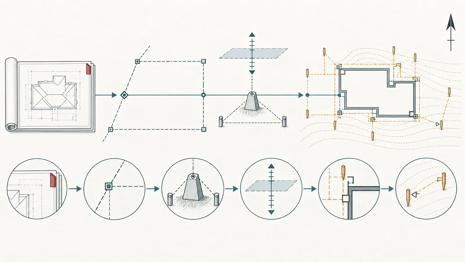
Do not infer that two plans agree because both use feet. Feet can be decimal feet or feet-and-inches notation; a survey may use one while a detail uses another. “Elevation 6.75” may mean 6.75 feet, while “6'-9"” is the same physical amount expressed differently. “100” may be an assumed finish-floor datum, not 100 feet above a national reference. Ask the surveyor or designer to resolve units in writing.
Worked illustrative elevation handoff
The following is an illustrative modeled example, not a field measurement or a recommendation for a particular property. It shows how to make the handoff auditable.
Assume the approved civil plan and staking sketch state:
- BM-1 elevation: 500.00 ft in the project vertical datum.
- Proposed finished-floor elevation: 506.75 ft in the same datum.
- Point G1 existing ground elevation from the survey: 505.10 ft.
- Point G1 proposed subgrade elevation: 503.90 ft.
- Point G2 existing ground elevation from the survey: 504.65 ft.
- Point G2 proposed subgrade elevation: 505.15 ft.
The useful formulas are:
target elevation = benchmark elevation + plan offset from benchmark, when the plan gives the target as an offset; or simply the target elevation stated on the plan if it is already in the same datum.
cut = existing elevation - proposed elevation, when the result is positive.
fill = proposed elevation - existing elevation, when the result is positive.
At G1, the cut is 505.10 ft - 503.90 ft = 1.20 ft cut. At G2, the fill is 505.15 ft - 504.65 ft = 0.50 ft fill. The homeowner should not turn those results into a machine instruction without the civil or grading plan's labels, slopes, compaction requirements and limits. The numbers merely show how a cut/fill note can be checked for sign and unit consistency.
The handoff record would state that BM-1, G1 and G2 came from the same survey issue, use the same project datum, and are not independent homeowner measurements. It would identify who set or verified them and whether the grade marks represent existing surface, subgrade, finished grade or another line. If the stake says “CUT 1.2,” the record should not silently convert that to “excavate 1.2 feet” until the builder confirms the mark's reference surface and the plan's excavation allowances.
Sensitivity to a plan revision or disturbed benchmark
Sensitivity is a way to reveal which inputs matter; it is not a tolerance statement. In the illustrative example, suppose a signed plan revision raises the target at G1 from 503.90 ft to 504.15 ft while existing ground remains 505.10 ft. The illustrative cut becomes 505.10 - 504.15 = 0.95 ft, a change of 0.25 ft. That is not cosmetic if a footing, drain, driveway tie-in or finished-grade relationship depends on it.
Suppose instead the benchmark is disturbed and a person assumes the replacement mark is 0.10 ft higher than BM-1 without a surveyor's verification. Every target elevation transferred from that control could be shifted by the same 0.10 ft, subject to the actual method and network. The correct response is not to subtract 0.10 ft from every stake. The surveyor must re-establish or verify control and document the result.
Horizontal sensitivity works the same way. If an offset hub is moved 0.15 ft, the homeowner cannot judge from a photo whether the footing is still acceptable. The significance depends on the offset, the design clearance, the local standard, the foundation geometry and the surveyor's stated tolerance. Mark it as disturbed, stop relying on it, and request a reset or written professional direction.
Run the handoff: surveyor to civil engineer to builder to authority #
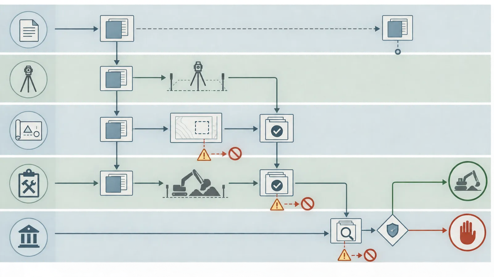
The cleanest handoff has four distinct owners: the surveyor establishes field control, the civil engineer or designer resolves grading and drainage meaning, the builder typically verifies receipt and protects the marks, and the authority controls permits and inspections. That is a typical allocation, not a universal legal rule: confirm the actual contract, owner-builder arrangement, permit holder, excavation subcontract and employer/competent-person roles. The homeowner coordinates the record and asks for gaps to be closed; the homeowner should not silently become the certifying party.
1. Owner or permit holder: assemble and authorize
The owner or permit holder supplies the surveyor with the controlled plan set, permit conditions, relevant approvals and site access instructions. The owner should state the decision date, requested scope and known constraints. If the site has a private road, gate, neighbor access, steep slope, protected tree, wet area or seasonal drainage path, include that information before the surveyor arrives.
The owner also decides who has authority to approve a change. A common failure is a field conversation in which an excavator says, “We can move this corner two feet and make it work,” followed by a verbal acceptance from someone who is not the designer, surveyor, engineer or permit holder. The release sheet should name the change authority for position, elevation, grading, structure, utilities and permits. If those names differ, keep the decisions separate.
2. Surveyor: set, describe and protect control
The surveyor reviews the requested plan issue and sets the control and construction marks within the scope contracted. Where a local authority requires a licensed surveyor, the surveyor's license and professional responsibility are part of the gate. Monterey County, California is one example: its staking page says the inspection process verifies work surveyed by a California-licensed surveyor and calls for marking boundaries, benchmark, structure corners and grading limits. The requirement belongs to Monterey County; confirm the actual licensing and inspection rule for the property jurisdiction. Monterey County's local surveyor and staking requirement
Ask for the surveyor's field sketch, stake list, control notes or other deliverable that the contract includes. It should be possible to identify the plan issue used, the control basis, the mark type, the offset, the elevation note and the reset contact. A homeowner can ask questions about meaning and preservation. A homeowner should not ask an unlicensed person to move a survey stake, extend a boundary line or calculate a new foundation location.
3. Civil engineer or designer: confirm design meaning
The civil engineer or designer connects survey control to grading, drainage, access and finished-site performance. This professional resolves whether a mark means subgrade, finished grade, footing bottom, pad, driveway tie-in, swale invert, top of wall or another design surface. The surveyor may set the mark, but a surveyor is not automatically the person who can change the drainage design, structural foundation or erosion-control plan.
The handoff should ask the design professional to confirm:
- the plan revision and sheets used;
- the finished-floor, pad, foundation and drainage elevations;
- the limits of cut, fill, export, import or over-excavation shown;
- what must remain untouched for drainage, stabilization, tree protection, wetlands or access;
- how the building footprint relates to the excavation footprint;
- which field conditions require a stop and request for information;
- whether the grading permit, stormwater plan or erosion-control plan adds a separate inspection or release.
If existing conditions do not match the survey, do not ask the excavator to “split the difference.” A mismatch may indicate a wrong benchmark, a revised plan, an unrecorded improvement, settlement, a map error, a changed drainage condition or a survey stake that moved. The designer and surveyor need the same photos, station or mark description and plan issue to diagnose it.
4. Builder: receive, verify and protect
Under a typical prime-builder contract, the builder owns construction means and sequencing after receiving the professional information, but the contract may assign work to an excavation subcontractor or the owner may be acting as an owner-builder. Confirm who is the actual permit holder, who employs or controls the excavator, who is the competent person, and who has authority to stop work. Those role facts govern the handoff; a homeowner's release sheet cannot transfer an employer's safety duty. The builder or designated controlling contractor should walk the site with the plan and surveyor's instructions, identify marks that machinery may destroy, establish a protection plan and tell every crew what not to move. A stake outside the footprint may be the only surviving offset for a corner; a benchmark near an access route may be vulnerable to a loader; a driveway mark may be needed to keep delivery traffic from crossing an erosion-control feature.
The builder's verification is a receiving check, not a re-survey. It should cover:
- plan and revision match;
- north/orientation and major site relationships;
- building or foundation marks are labeled and distinguishable from property corners;
- offsets and witness marks are understood;
- benchmark is described, photographed and protected;
- grading limits and no-disturb areas are visible;
- the proposed equipment route does not destroy control before the excavation is checked;
- access, laydown and spoil areas do not conflict with drainage, utilities or protected features;
- a reset protocol is understood by the foreperson and excavator;
- the competent-person and utility procedures are ready before workers enter or digging approaches marked lines.
The builder should not report “survey verified” if no surveyor performed a verification. Better language is “builder received and compared the staking to the approved plan; surveyor remains responsible for survey control; open item: confirm G2 grade stake meaning.” Precision in the record prevents an administrative sign-off from being mistaken for a professional certification.
5. Authority: control local release and inspection
The local building, grading, planning, public works, environmental or fire authority decides which permit and inspection gates apply. The actual jurisdiction matters. A local page may permit early staking while prohibiting excavation, require a pre-site inspection, or apply a volume threshold that differs from the neighboring county.
Sacramento County, California provides a clear example of why a homeowner must read the actual policy. Its policy says work requiring a building permit cannot begin without an issued building permit at the site and that a submitted plan is not enough. It also describes limited early activities such as staking, batter boards and lining out, but lists conditions and restrictions, including a 350-cubic-yard grading or excavation threshold for a grading permit and a prohibition on underground plumbing, electrical or utility work under the listed early-work guidance. These statements are Sacramento County's policy, not permission for a different county. Sacramento County's Building/Working Prior to Permit Issuance Policy
Ask the authority specific questions instead of “Are we good to dig?” For example:
- Is the building permit issued and physically or electronically available at the site as required?
- Is a grading permit required for the planned cut, fill, excavation or export volume?
- Is a pre-site or pre-construction inspection required before clearing, staking or excavation?
- Must a surveyor mark property boundaries, building corners, benchmark and grading limits?
- Is a separate driveway, right-of-way, encroachment, stormwater, tree, erosion or environmental approval required?
- Which inspection must occur before footing excavation, before placement of steel, or before covering work?
- Does the authority require a particular inspection card, photo record or survey certification?
Save the authority's answer with date, name, department and permit number. A web page is a starting point; a site-specific card or written direction controls when it is current and applicable.
Use the construction-staking release sheet #
The release sheet should let a new person reconstruct the decision from the plan, field mark, datum, responsible owner and dated evidence without relying on memory. It is a homeowner coordination tool, not an official inspection form, survey certificate, engineering document, legal boundary record or excavation-safety plan.
Construction-staking release sheet: plan-to-field handoff
Copy the following fields into the project record. Leave a field blank only when it is genuinely not applicable; write “not applicable—confirmed by [name/date]” rather than silently omitting it.
Project identity
| Field | Record |
|---|---|
| Property address and parcel/APN | |
| Actual jurisdiction, county/state and authority contact | |
| Owner/permit holder | |
| Builder and excavation subcontractor | |
| Decision date and planned first excavation date | |
| Building permit number and issue status | |
| Grading/erosion/access/environmental permit numbers | |
| Plan set name and complete revision/date | |
| Sheets controlling site, civil/grading, foundation and drainage work | |
| Surveyor, license state/number if relevant, contact and staking date | |
| Civil engineer/designer and engineer-of-record contact | |
| Builder's receiving foreperson and reset contact |
Survey control
| Field | Record |
|---|---|
| Horizontal control or survey basis | |
| North/orientation reference | |
| Property monuments found, set or witnessed | |
| Boundary status and unresolved encroachments | |
| Benchmark ID/number | |
| Physical benchmark description | |
| Benchmark witness ties and dated photographs | |
| Benchmark elevation | |
| Vertical datum or project/assumed datum | |
| Units and notation used | |
| Conversion to authority-required reference, if any | |
| Backup control or reset procedure | |
| Who may authorize a reset |
Marks requested and received
| Requested mark | What it represents | Label/offset/elevation | Set by/date | Protected by | Received/verified by/date |
|---|---|---|---|---|---|
| Property corners or boundary witnesses | |||||
| House/foundation corners | |||||
| Offset hubs/batter boards/reference lines | |||||
| Excavation or grading limits | |||||
| Pad, finished floor or subgrade references | |||||
| Driveway entrance, exit and access centerline | |||||
| Drainage, swale or outlet controls | |||||
| Tree, wetland, habitat or no-disturb limits | |||||
| Utility conflict or hand-expose locations |
Verification record
| Check | Result, evidence and open item |
|---|---|
| Plan revision on survey request matches approved plan | |
| Plan revision on survey deliverable matches request | |
| North/orientation and property relationships make sense | |
| Corners or offsets are labeled with meaning | |
| Benchmark is physically identifiable and protected | |
| Datum, units and elevation reference are explicit | |
| Grading limit and surface meaning are explicit | |
| Driveway/access route is usable without destroying control | |
| Protected features are marked and communicated | |
| 811 ticket number, date and state center | |
| Every utility owner has responded or an exception is resolved | |
| Private lines, septic, well, irrigation, lighting or owner-installed services addressed | |
| Local authority permit and inspection gate confirmed | |
| Soil, groundwater, slope and weather constraints reviewed by builder/professional | |
| Excavation competent-person assignment confirmed by builder | |
| Photos saved with file names, date and location | |
| Open items have owners and stop/go status |
Release status
Choose one and sign only for the role you actually hold:
- HOLD — do not excavate. Use for missing permit/inspection, wrong plan, unclear datum, unresolved utility response, missing survey control, disturbed critical mark, unsafe access or unreviewed design conflict.
- CONDITIONAL — limited work only. Name the exact area and action allowed, the condition that remains, the owner, the deadline and the event that stops work. Do not use this status to disguise a missing prerequisite.
- RELEASED FOR THE NAMED SCOPE. State the exact scope, plan revision, date, excluded areas and next inspection or handoff. This status does not certify survey accuracy or excavation safety.
Owner/permit-holder receipt: ____________________ Date: __________
Surveyor set or deliverable reference: ____________ Date: __________
Civil/design confirmation: _______________________ Date: __________
Builder receiving verification: ___________________ Date: __________
Authority confirmation or inspection reference: ____ Date: __________
The original contribution and how to check it
The original contribution in this guide is titled “Construction-staking release sheet: a plan-to-field handoff.” It is a worksheet rather than a claim that a new legal or engineering standard exists.
Its summary is practical: the sheet ties each visible mark and approval gate to the approved plan, survey control, responsible person, evidence and next handoff. Its method is explicit: “Map every release item from the approved plan to a named source, field mark, datum or permit condition, then test the handoff with an illustrative elevation calculation and sensitivity checks.” To check the method, take one real project packet and see whether another person can answer, for every mark, what it means, which plan issue created it, which datum controls it, who set it, who received it, what protects it and what happens if it is disturbed. Then change one input—plan revision, benchmark status, utility response or access condition—and see whether the sheet forces a new decision rather than hiding the change.
The limitations are equally important: “This worksheet organizes evidence and exposes missing control; it does not replace a boundary survey, construction staking by a licensed surveyor, an engineer's design, a utility locate, a permit or an authority inspection.” It also does not establish a universal tolerance, tell an excavator how to slope or shore soil, determine whether a local permit is required, or turn a homeowner's photograph into a professional verification. The evidence behind the worksheet includes Monterey County's local staking and pre-site examples, Boulder's local survey and datum examples, Sacramento County's local early-work policy, NGS datum definitions, OSHA excavation requirements and national 811 guidance. Each source is used only within its stated scope.
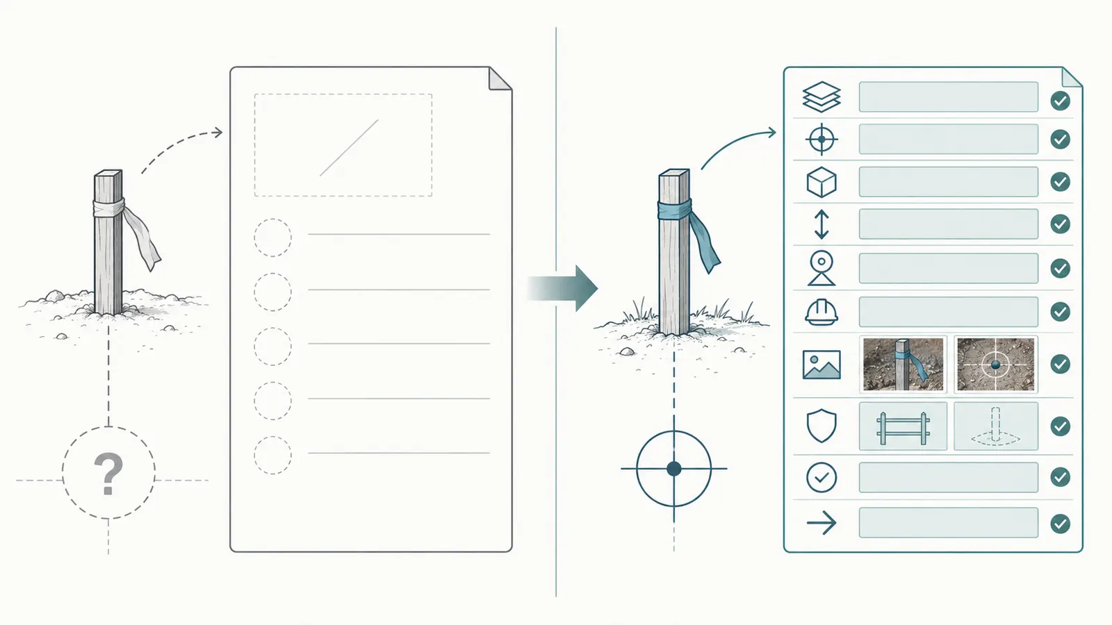
Photo and file naming that survives a dispute
The best record is one that remains intelligible after the lath is gone. Use a consistent file name such as 2026-09-08_BM-1_context_plan-C2.1-rev-B.jpg, 2026-09-08_House-SW-offset-detail.jpg and 2026-09-08_release-sheet_rev-C.pdf if the project system supports PDFs. Do not add a coordinate or elevation to a photo name unless a professional gave you that value; a filename is not a measurement.
For each important mark, capture:
- a context view showing the mark relative to the lot, access and fixed features;
- a detail view showing the label, flag or paint;
- a plan excerpt or sketch reference, without editing the original plan;
- the date and person who took the photo;
- any protection installed around the mark;
- a note if the photograph was taken before or after equipment entered the site.
Photos do not prove the mark is correct. They prove what was visible when recorded and can help a surveyor identify what changed. If a photo shows a stake leaning, a benchmark obscured by soil or a line with two labels, treat that as a question rather than a pass.
Test the exceptions: revised plans, missing marks, utilities, weather and access #
A release remains valid only for the named plan, area, time and conditions; a revision, disturbed mark, missing utility response, changed weather or blocked access reopens the decision. The most expensive mistakes happen when a once-correct release is treated as permanent permission.
Plan revision after staking
If a plan revision moves the footprint, finished floor, driveway, retaining wall, drainage feature or excavation limit, place the release on hold for affected marks. Do not assume that an unchanged architectural sheet means the civil or structural stake set remains correct. Ask the designer or engineer to identify the affected sheets and the surveyor to confirm which marks are invalid, which can be retained as reference and which must be reset.
The release sheet should include a revision comparison with four columns: old value, new value, field marks affected and professional disposition. For example, a 0.25-foot finished-floor change may change cut/fill, steps, foundation exposure, drainage slope and service-entry relationships. The illustrative sensitivity above shows why a plan revision is an input change, not a clerical update.
Do not let a field crew mark the new condition with a different color and proceed unless the change has been authorized and the record says exactly which work is allowed. Color conventions vary and fade. The plan revision, written direction and reset record are the durable controls.
Disturbed or missing benchmark
If the benchmark is missing, covered, struck, buried, moved, cracked, inaccessible or described differently on site, stop relying on it. Place a visible hold notice in the project record and contact the surveyor. Do not use a curb, fence, nail, pipe, rock or nearby stake as a substitute because it “looks close.” A replacement benchmark must be re-established or verified using the surveyor's method and the project datum.
If the benchmark remains but a stake is missing, the consequence depends on whether the stake was redundant, an offset or the only accessible control. The homeowner cannot infer that it is harmless. Record the missing mark, last known photo, area of work and whether machinery or grading may have changed the ground. Ask the surveyor which marks are still valid and request a reset if required.
A benchmark should be protected from the work it controls. Protection may mean a witness stake, paint, fencing, a no-parking note or a location outside the equipment path, but the proper method comes from the surveyor and builder. Do not enclose a mark in a way that hides it from the inspector or makes it impossible to occupy.
Conflicting corners or boundary evidence
If a fence, monument, GIS map, old survey and construction stake disagree, do not choose the one that gives the largest building pad. Record the conflict and refer it to the surveyor. A boundary issue can affect setbacks, easements, access, neighbor rights and legal exposure. The builder may be able to continue unrelated preparation in a confirmed area, but should not excavate an affected footprint until the control is resolved.
If the conflict is only an apparent orientation issue, have the surveyor explain the basis of bearings and north arrow. A plan can be rotated on a sheet while dimensions remain correct; a field crew can also misread a compass direction. The resolution belongs in the record so the same question does not return when forms or utilities are installed.
Utility marks and the limit of 811
Call 811 or use the applicable state center before every planned excavation according to the actual state process. The Common Ground Alliance's national 811 guidance says to contact 811 or the state center a few business days before digging, provide the address, county, nearest cross street, project type and exact dig area, then wait for utility responses and dig carefully around marks. The national service is a starting point; notice periods, ticket life, tolerance zones, private lines and state obligations vary. 811 Before You Dig's homeowner process
An 811 ticket is not a survey of the house corners. It is not permission to excavate through a color mark. In California and Nevada, USA North 811 says utility operators locate only facilities they own or operate and that private lines may not be covered by standard 811; its examples include electrical lines to detached buildings or outdoor lighting, gas lines to grills or pools, water lines to sprinklers or outbuildings and communications lines to secondary buildings. USA North 811's private-locator guidance For another state, ask the applicable 811 center and each utility owner what the ticket covers; treat owner-installed water, septic, irrigation, lighting, low-voltage, fuel and downstream service lines as unresolved until the responsible utility or private locator identifies them.
Record the ticket number, request area, date, state center, each utility's response, any no-conflict response and the marks' condition. Brictale's conservative homeowner release gate is to hold the affected excavation until every applicable responder has produced a recorded response and every known private facility has a documented owner or locating plan. That is Brictale scope, not a claim that OSHA always requires an absolute wait for every response. The current 29 CFR 1926.651(b)(2) rule says the employer must contact utility owners within established or customary local response times; if an owner cannot respond within 24 hours, or a longer period required by state or local law, or cannot establish the exact location, the employer may proceed with caution using detection equipment or other acceptable means. As excavation approaches the estimated location, 29 CFR 1926.651(b)(3) still requires the exact location to be determined by safe and acceptable means. The current eCFR text of 29 CFR 1926.651 This employer-facing exception does not authorize a homeowner or unqualified crew to improvise; state or local law, the utility owner, the employer's competent person and the actual excavation plan may impose stricter controls.
Never let a construction stake, utility paint line or plan symbol be treated as the other two. The builder needs a combined field plan: survey control for geometry, utility responses for underground conflict, and the excavation method for safe exposure and support.
Rain, groundwater, slope and changing conditions
A dry pre-stake walk does not release excavation after heavy rain, runoff, groundwater emergence, a slope movement, a vehicle impact or a change in adjacent loading. Monterey County's pre-site checklist is a local example of the conditions an authority may inspect: topography, slope grades, erosion, drainage, land movement, stockpiling and whether a grading permit is required. Its thresholds and process are for Monterey County, California. Monterey County's pre-site inspection checklist
The homeowner can photograph standing water, rills, sloughs, cracks, exposed roots, leaning stakes, ponding near the planned footprint or access that has become impassable. The homeowner should not enter an excavation to inspect it or direct a worker to pump, shore, slope or climb based on a photograph. Send the observations to the builder and relevant professional. The next release may require revised erosion control, a dewatering plan, a slope review, a reset survey or an authority inspection.
OSHA states that a competent person must inspect excavations before construction begins, daily before each shift and after rainstorms or other events that increase hazards, and must have authority to remove workers from a hazardous area. That duty belongs to the employer's qualified safety process; it is not satisfied by a homeowner's release sheet. OSHA's competent-person guidance
Access, equipment and the marks that get destroyed first
The construction route must be part of the release. A surveyor may set a benchmark beside the only driveway. A delivery truck may need to cross the grading limit. A temporary road may change drainage. Spoil piles may block an offset hub. The builder should map a route for surveyor access, utility locating, equipment, material delivery, emergency access and inspection access before excavation begins.
Keep control outside the machine's swing and travel path where practical, but do not relocate or reset it casually. If a mark cannot be protected in place, have the surveyor create an approved offset or witness arrangement. The release sheet should identify which marks may be removed after a later handoff and which must remain until foundation or grading verification.
OSHA's excavation guidance says spoils and equipment should be kept at least 2 feet from the edge of an adequately protected excavation or retained, but the exact site protection plan depends on soil, depth, geometry, protective system and employer responsibilities. The 2-foot figure is not a general setback from a pre-excavation stake and is not permission to stockpile wherever the survey marks remain visible. OSHA's excavation eTool
Apply the local rules without overgeneralizing #
Use local pages to identify the authority, trigger and named inspection, then verify the actual jurisdiction's current permit card, grading policy, survey requirement, utility-marking rules and inspection sequence before release. A national homeowner workflow can organize the questions, but only the applicable authority and qualified professionals can determine the local gate.
Monterey County, California: a staking-and-pre-site example
For a property in Monterey County, the named county staking page says the surveyor must mark property boundaries, benchmark location, structure corners and grading limits as part of the inspection process. It lists local examples of four parcel corner markers, four structure corner stakes, driveway entrance/exit stakes and tree identification markers, and says a grading inspector schedules a pre-site visit to verify construction staking and site conditions. Monterey County's staking page
The county's pre-site checklist also says the grading inspector checks project location on plans, corners, topography, slope grades, erosion, grading and drainage hazards, land movement, retaining-wall needs, stockpiling and grading-permit triggers. For a Monterey County homeowner, those named items belong in the release conversation. For a homeowner in another California county or another state, they are questions to ask, not automatic requirements. Monterey County's pre-site checklist
The practical sequence in Monterey County is therefore not “stakes down, excavator arrives.” It is: identify the permit and inspection path; complete the required pre-site paperwork or scheduling; have the surveyor set the required control and marks; verify visible site conditions; resolve grading, drainage, slope, stockpile or tree questions; then follow the inspector's release and builder's safety process. The county page should be reread at the time of work because pages and forms can change.
Boulder, Colorado: survey, site-plan inputs and vertical reference
For a property in the City of Boulder, the residential permit guide gives a different emphasis. It requires surveys to be stamped by a Colorado-licensed land surveyor and describes a survey-based site plan with property lines, rights-of-way, easements, existing and proposed improvements, access, utilities and topography. It also includes specific elevation and USGS-reference examples for building-height information. City of Boulder's survey and site-plan guidance
The homeowner's release sheet for Boulder should therefore make the survey stamp, topography source, property and easement relationships, utility information, access width, low point and vertical reference visible. The guide says an arbitrary vertical datum may be used if the elevations also include the USGS conversion value; this demonstrates why “finished floor 100” cannot be copied without the paired reference. It does not mean every U.S. jurisdiction uses USGS values in the same way.
If a Boulder lot has steep slope, mass movement or shrink/swell concerns, the city guide describes grading and drainage or soils inputs that may be required and may require a Colorado-licensed professional engineer. Those constraints reinforce a general rule: staking cannot make an unresolved geotechnical or drainage condition disappear. The authority and project professionals decide whether the stake request must wait for an engineered plan.
Sacramento County, California: permit and early-work boundary
For a property in Sacramento County, the county policy says work requiring a building permit cannot occur without an issued building permit at the site, and that submitting plans for review does not satisfy that requirement. It describes a stop-work consequence for covered work without the permit. Sacramento County's permit-issuance policy
The same policy lists limited early activities, including staking, batter boards and lining out, but it also states that erosion, sediment and water-pollution controls must be in place as required; grading or excavation over 350 cubic yards requires a grading permit; and the listed early-work guidance does not allow foundation forming, underground plumbing, underground electrical or utility work. That is precisely why “staking is allowed” cannot be paraphrased as “excavation is allowed.” The actual work scope, permit status, volume, inspection and exceptions must be checked with Sacramento County. Sacramento County's early-work guidance
The homeowner should ask the builder to write the intended first operation in plain language: “set offset hubs,” “clear within approved limit,” “excavate footing trenches,” “mass grade pad,” or “install underground service.” Each operation may have a different permit or inspection consequence. A release for staking is not a release for underground work.
Remote-assessment limits and the actual authority
No online guide, including this one, can determine whether your permit is active, your benchmark is stable, your foundation is correctly located, your soil needs shoring, or your private utility is clear. A remote review cannot see whether a stake label is legible, whether a slope has cracked overnight or whether a plan sheet in the excavator's cab is superseded.
For the actual property, identify:
- the city, county, tribal or other land-use authority;
- the building, grading, public-works, stormwater, fire, environmental and utility jurisdictions that apply;
- the permit card and conditions;
- the state's 811 center and notice requirements;
- the licensed surveyor and engineer responsible for the plan;
- the builder's safety contact and competent person;
- the authority's required inspection before the next irreversible operation.
If two authorities give different answers, preserve both, ask which department has jurisdiction for the specific operation, and obtain written clarification. Do not resolve it by choosing the less restrictive answer.
Release, stop, and choose the next decision #
The final release should name the exact scope that may proceed, the plan and control used, the open exclusions, the responsible next handoff and the condition that cancels the release. If any critical item is unknown, the next decision is not “how to dig around it”; it is “which professional or authority must resolve it, and what evidence will close the hold?”
The pre-excavation walk
Hold a short walk with the owner or permit holder, builder/foreperson, surveyor or survey deliverable, and civil/designer representative when the plan is complex. Invite the authority or inspector when the local process calls for it. Walk from the property access to the benchmark, control points, building footprint, grading limits, drainage path, protected features, utility marks, laydown area and intended excavation.
At each point, ask three questions:
- What are we looking at? Identify the mark, line, surface or condition.
- What document or professional gives it meaning? Identify the plan sheet, survey note, permit condition or safety plan.
- What would make us stop? Name the change, damage, mismatch or hazard and who must respond.
The third question is the one that prevents momentum from replacing judgment. “If this stake is gone, call the surveyor.” “If the 811 response is incomplete, do not approach the line.” “If the benchmark is covered by fill, stop using it.” “If a storm creates runoff or a crack, the competent person and engineer review conditions before workers enter or the plan proceeds.”
Release checklist
Use this condensed checklist at the end of the walk:
- Actual jurisdiction and applicable authority contacts are written down.
- Building permit status is confirmed; grading, erosion, access, environmental and other permits are checked.
- Local pre-site or staking inspection requirement is confirmed.
- Approved plan set, revision/date and controlling sheets are identified.
- Surveyor's scope, credentials where required, set date and deliverable are recorded.
- Horizontal control, property evidence, north and offsets are explained.
- Benchmark physical description, elevation, datum, units and witness ties are recorded.
- Finished floor, foundation, pad, subgrade, drainage and grade meanings are distinguished.
- Building corners, excavation/grading limits, driveway/access and protected features are marked or intentionally excluded.
- Every mark has a protection and reset plan.
- 811 ticket is current for the actual dig area and utility responses are complete.
- Private utilities and owner-installed lines have a separate plan.
- Equipment, traffic, laydown and spoil areas do not destroy control or violate the builder's safety plan.
- Soils, groundwater, slope, rain and erosion conditions are reviewed by the builder and relevant professionals.
- A qualified competent person is assigned for excavation safety and has authority to stop work.
- Photos and records are dated, labeled and stored with the plan revision.
- Open items have an owner, deadline and explicit hold or conditional status.
- The next handoff and inspection are named.
What the homeowner can safely do
The homeowner can assemble documents, compare revision labels, photograph visible marks from outside hazards, record names and dates, ask what a mark represents, check that the permit card and inspection instructions are present, protect the record, observe whether utility responses are missing and stop the release when a required gate is not documented.
The homeowner can also ask for a written explanation in ordinary language. Useful questions include: “Is this the foundation corner or an offset?” “What does the number represent?” “Which datum and units are behind this elevation?” “Which plan revision did you use?” “If this stake is destroyed, who resets it?” “What work is allowed before the inspection?” “Which private lines are outside the 811 locate?” “What weather or soil change cancels today's release?”
The homeowner should not set or move survey control, certify a boundary, calculate a foundation position from a photograph, approve an engineering change, identify a buried utility by digging, enter a trench, direct a worker to undermine a mark, decide that spoil is safely placed, or replace a competent person's excavation inspection. Those tasks belong to the responsible surveyor, engineer, utility professional, builder and authority.
What the builder and professionals should receive
Before the excavator mobilizes, send one controlled release packet containing:
- the approved plan set and revision register;
- staking request and surveyor's field sketch or deliverable;
- benchmark and horizontal-control record;
- civil/grading/drainage and soils information;
- permit cards, conditions and inspection status;
- 811 ticket, responses and private-utility notes;
- access, protection, erosion and environmental restrictions;
- dated photos of marks and protected features;
- the completed release sheet with open items;
- the next inspection or design handoff;
- the names and phone numbers for survey reset, design questions, authority questions and safety stop.
Do not send only a photograph of four stakes. The crew needs the meaning behind the stakes and the limits of what is released. The homeowner needs a record that can be checked after a weekend, rainstorm, delivery, plan change or personnel change.
Excavation safety boundary
Excavation is a high-safety activity. OSHA's rules and guidance address cave-ins, protective systems, soil classification, surcharge loads, water, access/egress, hazardous atmospheres, underground installations and competent-person inspections. OSHA says a stairway, ladder, ramp or other safe egress method is required in trench excavations 4 feet or more deep so that employees do not travel more than 25 feet laterally, and its guidance addresses keeping spoils and equipment back from excavation edges. OSHA's 29 CFR 1926.651 excavation standard
The homeowner should stay out of open excavations and keep children, guests and untrained people away from the work zone. Do not infer safety from a shallow-looking cut, dry weather, a broad footprint or a contractor's confidence. Soil can fail without an obvious warning, water can change the condition, and nearby equipment or spoil can add load. The builder's competent person must control worker entry and changing conditions. When in doubt, pause the release and contact the builder's safety lead.
Brictale's remote and no-go boundary
A homeowner should not enter, expose, touch or direct work around a suspected electrical or potentially pressurized utility line, contaminated soil or hazardous air, a confined-space or trench excavation, or any unstable cut. This is Brictale's conservative remote-assessment boundary: visible stakes and photographs cannot establish whether a line is energized or pressurized, whether soil contains contamination, whether an atmosphere is breathable, or whether a trench has a protective system. Keep people away, stop the affected operation and hand the issue to the utility owner or qualified private locator, the builder's competent person, and—when contamination, hazardous air, soil or structural conditions are possible—the appropriate environmental, geotechnical, civil or structural professional. Do not open a suspected pressurized line, probe near electrical infrastructure, collect contaminated soil or enter a trench to investigate. OSHA's current excavation rule addresses atmospheric testing and precautions where oxygen deficiency or a hazardous atmosphere exists or could reasonably be expected in an excavation deeper than 4 feet; that employer duty reinforces the boundary but does not turn this article into an entry procedure. 29 CFR 1926.651(g), current eCFR text
If a utility is struck, a gas or fuel odor is present, a line hisses, electrical equipment is damaged, a person feels ill, or soil or air may be contaminated, leave the area and use the utility owner's emergency process or 911 when there is immediate danger. The homeowner's next decision is who must make the site safe—not whether a photo, stake or release-sheet checkbox is enough.
The next decision after release
Once a named scope is released, the next decision should be equally specific. It may be:
- surveyor returns to reset BM-1;
- civil engineer confirms the revised pad elevation;
- authority performs the pre-site or grading inspection;
- builder performs clearing only within the approved limit;
- builder exposes a utility by the approved safe method;
- excavator begins only the named cut after the competent-person check;
- surveyor verifies the excavation or footing location before the next irreversible work;
- engineer reviews unexpected soil, groundwater, rock, fill or movement.
Write the next decision before leaving the site. A record that ends with “ready” creates ambiguity; a record that ends with “next: excavation foreperson calls the surveyor if G1 or BM-1 is disturbed; no foundation excavation until authority inspection card item 4 is complete” creates a controlled sequence.
The highest-value habit is to make uncertainty visible early. A missing label, unexplained elevation, unreturned utility, changed plan, wet slope or damaged stake is not an inconvenience to work around. It is information that changes the release decision. The homeowner's job is to preserve that signal, bring the right professional into the handoff and keep the site from crossing an irreversible line before the record catches up.
Cite this guide
Brictale. “How to Prepare Construction Staking and Benchmark Release Before Excavating a New Home.” Published 2026-09-19; updated 2026-09-19.
https://brictale.com/build/land/prepare-vacant-lot-construction-staking-benchmark-release-before-excavation · Read the Markdown version
Original contribution: Construction-staking release sheet: a plan-to-field handoff. A reusable record that ties each visible mark and approval gate to the approved plan, survey control, responsible person, evidence and next handoff.
Sources and scope
Evidence behind this page
- Monterey County, California describes construction staking as a surveyor applying data from approved plans to the site to provide horizontal and vertical definition, including building corners or grading cut/fill based on the benchmark shown on the plans.
Staking For Grading Construction
Monterey County, California building inspection and grading-staking guidance; local example, not a national rule.
Accessed · Link to this claim - Monterey County, California states that its inspection process requires a California-licensed surveyor to mark property boundaries, benchmark location, structure corners and grading limits; the page also gives local examples for parcel corner markers, structure corner stakes and driveway markers.
Staking For Grading Construction
Monterey County, California; the named counts and licensed-surveyor requirement apply to that county's process.
Accessed · Link to this claim - Monterey County, California says a grading inspector schedules a pre-site inspection to verify construction staking and site conditions, and its checklist includes project location, proposed corners, topography, slope, erosion, drainage and possible retaining-wall or grading-permit issues.
Monterey County, California pre-site inspection guidance; use the actual local inspection card elsewhere.
Accessed · Link to this claim - The City of Boulder, Colorado residential permit guide says surveys must be stamped by a Colorado-licensed land surveyor and that a site plan based on a survey includes property lines, rights-of-way, easements, improvements, access, utilities and topographical information; city map topography is general information only.
Residential Building Permit Guide
City of Boulder, Colorado residential permitting; local submittal example, not a national survey standard.
Accessed · Link to this claim - The City of Boulder, Colorado permits an arbitrary vertical datum such as finished floor 100 only when relative elevations also include the USGS conversion value, and gives an example pairing finished floor 100 with 5325.00 USGS.
Residential Building Permit Guide
City of Boulder, Colorado building-height guidance; illustrates the need to record both a project datum and its authority conversion where required.
Accessed · Link to this claim - Sacramento County, California says construction work requiring a building permit must not begin without an issued building permit at the site; a submitted plan is not enough, and inspectors may issue a stop-work order for covered work without the required permit.
Building/Working Prior to Permit Issuance Policy
Sacramento County, California policy; not a nationwide permit rule.
Accessed · Link to this claim - Sacramento County, California lists limited early activities such as staking, batter boards and lining out as acceptable under its policy, while stating that grading or excavation over 350 cubic yards requires a grading permit and that underground plumbing, electrical or utility work is not allowed under the listed early-work guidance.
Building/Working Prior to Permit Issuance Policy
Sacramento County, California policy and thresholds; verify the current permit, environmental and grading rules for the actual site.
Accessed · Link to this claim - OSHA says excavation conditions require a competent person to inspect excavations before construction begins, daily before each shift and after rain or other hazard-increasing events, with authority to remove workers when hazardous conditions exist.
Trenching and Excavation: Competent Person
U.S. OSHA construction safety guidance for covered work; it does not certify a homeowner's site as safe or replace the employer's competent-person duties.
Accessed · Link to this claim - OSHA's construction standard requires a stairway, ladder, ramp or other safe means of egress in trench excavations 4 feet or more deep so employees need no more than 25 feet of lateral travel.
29 CFR 1926.651 Specific Excavation Requirements
U.S. OSHA construction requirements and related eTool guidance; apply through the builder's safety program and qualified competent person.
Accessed · Link to this claim - OSHA's trenching and excavation eTool states that spoils and equipment should be set at least 2 feet from the edge of an adequately protected excavation or retained to prevent material from falling back into the excavation.
Trenching and Excavation eTool
U.S. OSHA excavation-safety guidance; the setback is not a general pre-excavation stake rule and does not replace a site-specific protective-system decision.
Accessed · Link to this claim - The National Geodetic Survey defines a datum as a reference surface used to begin surveys and maps, identifies NAD 83 (2011/PA11/MA11) as a current geometric datum and NAVD 88 as a current vertical datum for U.S. federal mapping activities.
National Geodetic Survey reference information; the project authority, surveyor and plan set control the datum actually used for a home.
Accessed · Link to this claim - The Common Ground Alliance's 811 Before You Dig service says anyone planning to dig should contact 811 or the state 811 center a few business days before digging, provide the address and exact dig area, wait for utility responses and dig carefully around marks.
811 Before You Dig: How does 811 work?
National safe-digging service guidance; notice periods, private lines and state requirements vary, so the applicable state center and utility owner control.
Accessed · Link to this claim - The current eCFR text of 29 CFR 1926.651(b)(2) requires the employer to contact utility companies or owners within established or customary local response times and allows the employer to proceed with caution and detection equipment or other acceptable means when a utility cannot respond within 24 hours (or a longer period required by state or local law) or cannot establish the exact location; section 1926.651(b)(3) still requires safe and acceptable means as excavation approaches the estimated location.
eCFR § 1926.651, Specific excavation requirements
Current eCFR text accessed 2026-09-08 and displayed up to date as of 2026-09-03; employer duties for covered construction excavation, not a homeowner certification or a substitute for stricter state or local law.
Accessed · Link to this claim - 29 CFR 1926.651(g) requires atmospheric testing before employees enter excavations deeper than 4 feet where oxygen deficiency or a hazardous atmosphere exists or could reasonably be expected, and requires precautions against hazardous atmospheres.
eCFR § 1926.651, Specific excavation requirements
Current eCFR text accessed 2026-09-08 and displayed up to date as of 2026-09-03; employee protection in covered construction excavations, not permission for homeowner entry.
Accessed · Link to this claim - USA North 811, serving California and Nevada, says utility operators are responsible for facilities they own or operate and that private lines may not be marked through the standard 811 process; its examples include electrical lines to detached buildings or outdoor lighting, gas lines to grills or pools, water lines to sprinklers or outbuildings and communications lines to secondary buildings, with additional private locating steps needed.
Professional Excavators — Private Locators
USA North 811 service guidance for California and Nevada; private-line ownership, notice, locating and excavation rules elsewhere must be checked with the applicable state center and utility owners.
Accessed · Link to this claim