How to Choose Test Pits or Borings for a Vacant-Lot House Soil Investigation
Compare test pits, borings, and supplemental site work before foundation design, with a homeowner-ready scope and report handoff.
The short answer
Ask a qualified local geotechnical professional to select the investigation program after reviewing the house footprint, foundation concept, fill, slope, rock, groundwater, utilities, access, and drainage or infiltration locations. Test pits usually provide the clearest visual profile where a safe, accessible excavation is feasible; borings are often the practical choice for depth, tight access, utilities, existing improvements, or sampling. Require a written scope, logs, water observations, limitations, recommendations, and a handoff your foundation designer can use.How to Choose Test Pits or Borings for a Vacant-Lot House Soil Investigation
Ask a qualified local geotechnical professional to select the investigation program after reviewing the house footprint, foundation concept, fill, slope, rock, groundwater, utilities, access, and drainage or infiltration locations. Test pits usually provide the clearest visual profile where a safe, accessible excavation is feasible; borings are often the practical choice for depth, tight access, utilities, existing improvements, or sampling. Require a written scope, logs, water observations, limitations, recommendations, and a handoff your foundation designer can use.
This guide is for a homeowner planning a new house on vacant land in the United States before foundation design. It does not tell you how to excavate, enter a pit, drill, collect samples, or select final engineering depths. It helps you decide what to ask for, what the proposed method can and cannot show, who owns the next decision, and when a convenient-looking investigation is not enough.
1. Choose the method by the decision it must support #
The right method is the one that gives the responsible design professional enough relevant evidence at the right locations and depths to make the next decision, not the method with the lowest mobilization price or the most familiar name. For a straightforward, accessible area where visual continuity matters, ask whether exploratory test pits can reveal the soil profile. For deep, variable, water-bearing, rocky, constrained, or utility-sensitive conditions, ask whether borings, sampling, rock observations, groundwater observations, or additional methods are needed. The qualified geotechnical professional sets the final program.
That answer has an important U.S. boundary. The cited sources do not establish a nationwide legal rule that applies to every vacant lot: local building codes, adopted residential provisions, special geologic overlays, floodplain rules, stormwater programs, septic authorities, and permit reviewers can change what must be submitted. The brief for this article names New York City and Philadelphia as bounded examples, while the Texas source is professional guidance rather than a national code. Their rules and guidance help explain the decision, but neither local example is national law. A reader in Texas must not silently apply Philadelphia’s infiltration spacing; a reader in Oregon must not treat New York City’s test-pit exception as local approval. This limitation means you must verify the actual jurisdiction for the parcel rather than infer a nationwide permit requirement from the examples below.
The professional handoff is the core sequence. The Texas Section of the American Society of Civil Engineers describes an engineered foundation as a chain from geotechnical information supplied by a licensed engineer, to foundation design by a licensed engineer, to construction observation with written documentation. Its document says a geotechnical investigation and report should be completed before foundation design. That document is Texas professional guidance adopted in 2007, not a national code, but it provides a useful model for keeping responsibilities visible: Texas Section ASCE’s residential-foundation practice.
In practical terms, your decision is not “test pits or borings?” in isolation. It is closer to this:
Given the proposed house and site, which evidence must be obtained, where must it be obtained, which method can obtain it safely, what uncertainty will remain, and who will decide whether the evidence is adequate for foundation and site design?
This guide narrows an existing Brictale decision. The broader surveys and soil tests before designing a house on vacant land guide covers the earlier pre-design sequence and the reasons to investigate a site. This article goes one level deeper on the proposal choice between test pits, borings, and supplemental work, including how to tie each location and method to the next design handoff; it does not replace that broader prerequisite guide.
Originality brief: the missing homeowner decision
Current answers often explain that test pits expose soil and borings retrieve samples, then tell a homeowner to order a geotechnical report. Code excerpts describe a local substitution or depth rule. Engineering references describe field programs for professionals. The missing decision is how to translate the proposed home and visible site conditions into a scope request, how to recognize when a test is merely convenient, and how to check the report before paying a designer to proceed.
This guide’s original contribution is the Vacant-lot investigation method matrix and proposal crosswalk. It is a decision matrix synthesized from the source-bounded distinctions in the Texas Section ASCE practice, New York City’s local test-pit rule, Philadelphia Water Department stormwater guidance, USDA soil-survey limits, and OSHA excavation safety guidance. The method is to list the input, the decision it affects, the evidence a method can produce, the responsible professional, the jurisdictional verification, the unresolved uncertainty, and the next handoff. The matrix is illustrative: it is not a field protocol, an inspection form, a laboratory report, a foundation design, a code checklist, or a replacement for the qualified professional who sets final locations, depths, samples, and safety controls.
Method: Combine the supplied house and site inputs with source-bounded distinctions between test pits, borings, and supplemental observations; record the evidence produced, responsible professional, jurisdictional check, unresolved uncertainty, and next handoff for each decision.
Limitations: This is an illustrative planning and proposal-review tool, not a code checklist, field investigation, laboratory result, foundation design, or substitute for the qualified local professional who sets final locations, depths, sampling, safety controls, and report recommendations.
The matrix can be checked by asking five questions for every line in a proposal:
- What project input caused this work to be requested?
- What observation, sample, measurement, or limit will the work produce?
- Who is qualified and responsible for interpreting it?
- Which source or local authority supports the requirement, and what jurisdiction does it cover?
- What decision remains after the work, and what is the next handoff?
If a proposal cannot answer those questions, it may still be a valid professional proposal, but you do not yet have an auditable homeowner decision surface. Ask for clarification before treating the scope as foundation-ready.
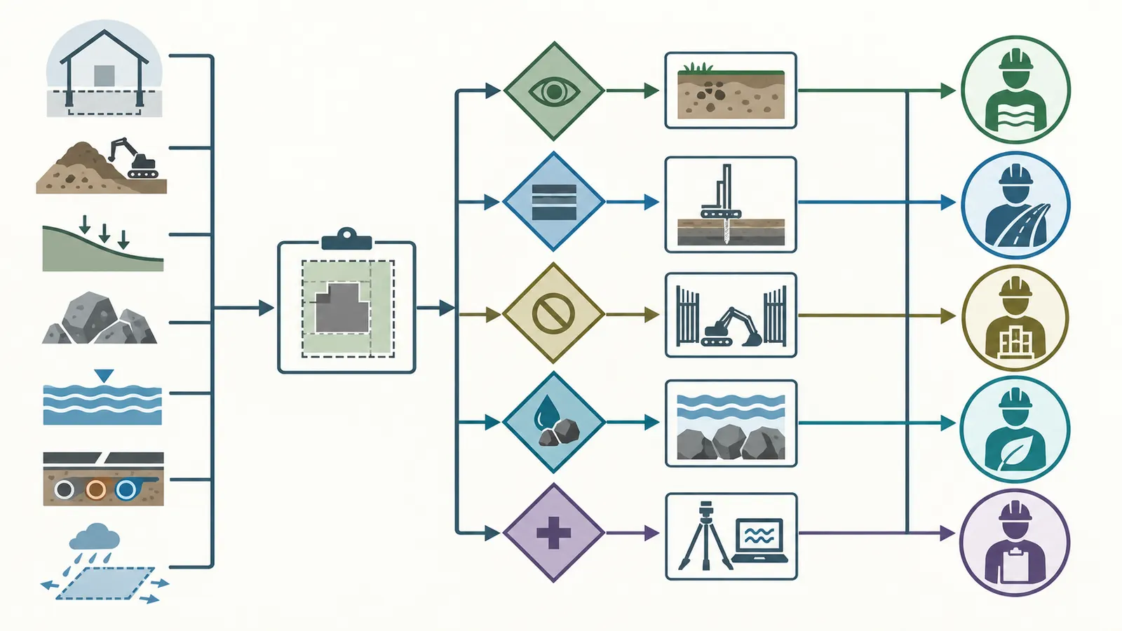
What you may do safely before field work
You can assemble records, photograph the lot from public or safe access areas, mark the intended house and driveway concept on a sketch, note visible slopes and wet areas, find prior surveys and permits, ask the seller for fill or grading records, and request a written scope from a licensed or otherwise qualified local professional. You can compare whether proposals name the same house assumptions and the same deliverable.
Photos, maps, videos, soil surveys, or remote advice cannot establish bearing capacity, earth pressure, hydrostatic pressure, shoring needs, dewatering requirements, or foundation adequacy for a particular lot. Those conclusions require site-specific work and interpretation by qualified geotechnical, foundation, civil, structural, environmental, or other local professionals as applicable. Treat remote material as a way to prepare questions and records, never as clearance to design, excavate, shore, dewater, or proceed.
You should not enter a test pit, climb its sides, reach into an open excavation, direct a machine operator from inside the work zone, expose utilities, or treat a hand-dug hole as a substitute for an engineered investigation. OSHA’s construction standard generally requires employee protection from cave-ins in excavations, with narrow exceptions for stable rock and shallow excavations inspected by a competent person; the standard also covers protective systems such as sloping, benching, and shielding. That is a workplace safety rule, not permission for a homeowner to enter a pit or a shortcut for choosing a method. OSHA’s excavation protective-systems standard.
2. Define the decisions before you request a price #
Before asking “How many test pits?” define what the investigation has to support. A qualified professional can then choose a method that matches the decision rather than quoting an unexplained count. At minimum, separate the foundation decision from the stormwater, driveway, retaining, septic, and environmental decisions. One investigation may inform several of them, but one convenient observation does not automatically answer all of them.
The foundation decision
The foundation designer needs enough information to understand the anticipated bearing materials, variability, fill or disturbed ground, compressible or expansive behavior where relevant, groundwater or seepage, rock, slope-related conditions, and construction constraints. The exact list depends on the house, local geology, foundation type, building code, and engineer’s judgment. The homeowner’s job is not to prescribe a bearing capacity or a minimum boring depth. The homeowner’s job is to make the proposed building and known uncertainties visible early enough for the geotechnical and foundation professionals to coordinate.
Give the professional at least these house inputs:
| Input | Record now | Why it can change the investigation question |
|---|---|---|
| Footprint | Approximate length, width, location, orientation, and finished-floor elevation | A small compact house and a wide split-level house load and disturb different parts of a lot. |
| Stories | Number of stories, attic use, crawlspace, basement, or lower-level garage | Height and below-grade work can change loads, excavation depth, and the relevance of groundwater or rock. |
| Foundation concept | Slab, crawlspace, basement, piers, wall-and-footing system, or not yet chosen | The investigation must support the options being considered; a basement question is not answered by a shallow surface observation alone. |
| Structural assumptions | Heavy masonry, large open rooms, concentrated posts, porches, retaining walls, pools, or additions | Concentrated loads and adjacent structures may require attention outside the simple house rectangle. |
| Finished grades | Approximate existing and proposed elevations, cut and fill areas, driveway grade | Cut, fill, drainage, slope stability, and retaining decisions can change where useful evidence is needed. |
| Construction sequence | Whether clearing, grading, temporary access, or mass excavation will happen before foundation work | A report based on existing ground may need explicit limits if the planned grade or fill will change. |
| Design stage | Land due diligence, schematic plan, permit plan, or foundation design underway | A preliminary desktop screen can be adequate for one decision and inadequate for the next. |
Do not wait for final architectural drawings if a major decision is already known. A rough footprint and foundation range are better than a vague “future house,” as long as you label them as assumptions. If the house location is not fixed, show two or three plausible zones and ask whether the investigation should distinguish them. If a designer later moves the house materially, ask the geotechnical professional whether the report still covers the new location and loads.
The site decision
Record what can change the continuity of the subsurface story. The Texas Section ASCE residential-foundation practice specifically tells its exploration program to consider vegetation, fill depth, drainage, seepage, slopes, fence lines, old roads or trails, man-made construction, seasonal weather cycles, and other conditions affecting foundation performance. This is Texas professional guidance, not a national checklist, but the categories are useful prompts for a U.S. homeowner’s site packet. See the site-factor discussion in the Texas practice.
Make a simple annotated plan with north arrow, approximate scale, property boundaries if known, street, access gate, existing trees, visible rock, low spots, wet spots, steep breaks, old drive or building pads, debris, stockpiled soil, buried tanks or wells if records mention them, overhead lines, utility markings, and the likely house and stormwater areas. Use words such as “observed from safe access” and “reported by seller” so a professional can separate observation from assumption.
Visible clues are signals, not diagnoses. A damp depression can indicate drainage, a perched water condition, a leaking utility, a spring, recent rain, or ordinary surface runoff. A color change can be a natural horizon, imported fill, staining, or moisture. A rock outcrop confirms rock at that location but does not prove the entire lot has shallow competent rock. A flat lawn can conceal old grading. A soil map can suggest regional patterns but does not show the actual condition beneath every square foot.
USDA NRCS explains that soil surveys map soil characteristics and may include properties such as depth, texture, particle-size distribution, plasticity, permeability, shrink-swell potential, corrosion, and erodibility. Its Web Soil Survey makes the mapped information publicly available. Use it to form questions and identify possible limitations, not to certify a house site. NRCS soil facts and soil-survey context.
NRCS also explains the boundary that matters here: soil surveys provide planning information, while onsite investigation is needed for intensive uses of small areas. That distinction is especially important for a house footprint, a retaining wall, a septic area, or an infiltration practice. NRCS’s explanation of soil-survey limits.
The stormwater and drainage decision
Identify every location where the project may ask soil to accept, convey, retain, or resist water. Include roof runoff practices, infiltration trenches, rain gardens, dry wells, detention or bioretention areas, foundation drains, swales, culverts, septic dispersal areas, and proposed retaining walls. These may be outside the house footprint and may require their own evidence.
Philadelphia Water Department guidance illustrates why location matters. Its testing-plan requirements identify proposed stormwater-management footprints, type, bottom elevation, test-pit and boring locations, test counts, test types, depths relative to existing ground, and dimensions from boundaries or structures. That is a Philadelphia stormwater program, not a national rule, but it is a strong proposal-review prompt anywhere a drainage feature is part of the project: Philadelphia Water Department infiltration and soil-assessment guidance.
Ask whether the foundation investigation and stormwater investigation can share information, whether each method is valid for both decisions, and what additional testing or sampling is required. Do not assume that a boring under the house answers an infiltration question 80 feet away, or that an infiltration test answers a foundation question beneath a future basement.
The legal and permit decision
Ask the building department, stormwater reviewer, septic authority, floodplain administrator, and geotechnical professional which current local provisions apply. Give the jurisdiction as a full name: city and state, county and state, or other authority. Record the source and adoption date in your project log. Do not copy a rule from a search result without checking the actual adopted text and whether it applies to a new one- or two-family residence, the proposed foundation, or a stormwater practice.
New York City Administrative Code section 27-664 is a useful example of why this matters. It says test pits may substitute for borings one-for-one while observing applicable requirements for depth, sample numbers, reported data, and sample disposition, with stated exceptions for spoon use, driving resistance, and rock cores. That is a New York City building-code provision, not a national allowance. Read New York City Administrative Code § 27-664.
The same New York City provision describes a special depth treatment for certain one-story buildings and one- or two-family residences no more than two stories high when supported on specified satisfactory bearing material. It refers to four feet below the deepest footing excavation or a four-foot minimum in the stated case; see the exact New York City Administrative Code § 27-664(b) depth language at the point of use. It does not mean every U.S. house can use four-foot test pits, and it does not eliminate the need to confirm bearing material, sampling, reporting, or other local requirements. Treat it as a jurisdiction-labeled example of how code can define an exception, not as a design recommendation.
3. Build a site packet that lets the professional choose well #
The best homeowner contribution is a complete, honest site packet. It improves the quality of proposals without putting you in the role of the geotechnical engineer. A sparse request such as “Please quote soil testing for a 2,000-square-foot house” forces the professional to guess about foundation type, slopes, grade changes, access, water, utilities, and report use. Those guesses can create exclusions, change orders, or a report that cannot support the design you actually want.
Packet item A: the house brief
Write one page with the current assumptions and a revision date. Include:
- parcel address, municipality, county, and state;
- parcel size and a boundary or survey source, if available;
- proposed house footprint and approximate area;
- stories, basement or crawlspace, slab, garage, porches, decks, and additions;
- likely foundation types, including alternatives still under consideration;
- approximate finished-floor elevation and whether the house will be cut into or raised above existing grade;
- heavy or unusual loads that are already known;
- architectural plan status and the person who can issue revisions;
- the target foundation-design handoff date;
- whether the purchase or financing decision depends on a usable report.
State unknowns explicitly. “Foundation not selected; basement and crawlspace both under consideration” is useful. “Standard foundation” is not precise enough to define the investigation. “House location shown for planning only” is also useful if the lot layout is still moving.
Packet item B: the site and history brief
Collect the survey, plat, listing photographs, seller disclosures, prior permits, grading plans, land-disturbance records, well and septic records, demolition records, aerial images if available, and any engineering or environmental reports. Keep the source and date for each document. If a document is missing, say missing rather than inferring that no work occurred.
Ask the seller or local authority about prior structures, removed tanks, imported fill, old driveways, agricultural use, dumping, underground utilities, quarrying, mining, buried debris, recurring flooding, springs, and prior failed septic or stormwater work. These are questions for history, not proof. A seller’s “never had water” statement does not establish seasonal groundwater conditions; a clean surface does not establish uncontaminated soil.
Make a photo log. For each image record date, approximate location, direction of view, recent weather if known, and what is visible. Photograph from stable ground and public or permitted access. Do not clear brush, dig exploratory holes, remove markers, or enter a suspected contaminated area to improve the record.
Packet item C: the constraints plan
Draw the proposed house, access route, likely rig or excavator position, overhead lines, neighboring structures, fences, trees, easements, utilities, septic reserve area, stormwater footprints, and areas too narrow or soft for equipment. Add dimensions from a fixed object where possible. A contractor’s statement that “the machine can get there” is not the same as a professional’s assessment of safe and useful access.
OSHA’s trenching and excavation guidance identifies water accumulation and hazardous atmospheres as risks and tells employers to contact utilities and assess proximity to underground lines and structures before excavation. The practical homeowner action is to disclose every known utility and obtain the site-specific utility-locate and access planning required by the field professional. OSHA trenching and excavation guidance.
Do not mark utilities from memory. Use the local one-call process and the professional’s site procedures. A homeowner must not locate, expose, disconnect, energize, isolate, or diagnose overhead lines, underground utilities, or private electrical service from remote information. Utility locating and isolation, along with field decisions about clearance or work near a line, belong to the utility owner and qualified field team under the applicable local process. Private lines, old services, irrigation, septic components, and abandoned infrastructure may require additional locating beyond public utility marks. Tell the geotechnical firm if the site has a private well, septic tank, buried fuel tank, geothermal loop, drainage pipe, or electrical service that does not appear on public records. OSHA’s utility-planning guidance supports planning around underground lines; it is not permission for homeowner electrical diagnosis or field work.
Packet item D: the questions the report must answer
Turn the house and site brief into outcome questions. A strong request does not say only “provide a soil report.” It asks for the report to state which decisions it supports and which it does not.
| Decision question | Evidence to ask the professional to address | Owner of the final decision |
|---|---|---|
| Can the proposed foundation concept be designed on the encountered materials? | Profile, material descriptions, samples or tests selected by the professional, groundwater observations, and design recommendations with limits | Foundation design professional, coordinated with geotechnical professional and local reviewer |
| Is the site uniform enough for one investigation area, or are zones different? | Locations tied to the plan, transitions, fill boundaries, rock, slope breaks, wet areas, and unresolved gaps | Geotechnical professional |
| Does planned cut or fill change the evidence needed? | Existing versus proposed grades, fill thickness or quality questions, compressible or unsuitable material concerns, and construction recommendations | Geotechnical professional and civil/foundation designer |
| Can a basement or deep excavation proceed as assumed? | Depth to rock, water observations, soil behavior, excavation or shoring considerations, and limits of the investigation | Foundation/civil/structural professionals; contractor handles means and methods |
| Can a proposed stormwater practice infiltrate at its selected location? | Site-specific characterization and infiltration testing under the local program, with depth/elevation and setback information | Civil/stormwater designer and reviewing authority |
| Are additional environmental or specialty studies needed? | History-based screening and a clear limitation or referral when contamination, wetlands, mines, karst, or other issues are outside the scope | Qualified environmental or specialty professional and authority with jurisdiction |
The table deliberately does not name a universal number of tests. Number, spacing, depth, samples, laboratory work, and monitoring depend on the project and local rules. A proposal that names these items can be compared; a proposal that omits them may still be fine, but ask the professional to explain what the lump sum includes.
Packet item E: the jurisdiction check
Send the same packet to the building official or plan reviewer and ask five bounded questions:
- Is a geotechnical report required for this lot, foundation type, slope, floodplain, fill condition, or permit path?
- Does the jurisdiction prescribe or accept a particular investigation method, substitution, sample record, or professional seal?
- Is there a separate stormwater, septic, erosion-control, or infiltration-testing requirement?
- Does the reviewer need the report before foundation design, with the permit set, or before a later inspection?
- Which adopted code edition and local amendments control the decision?
Save the response with the official’s title, office, date, and source link. A verbal answer may be useful for planning, but ask how to document it for the permit record. If the official says “ask your engineer,” that is not a failure; it means the professional must include the code-relevant question in the scope.
4. Compare what test pits and borings actually show #
Test pits and borings are not two brands of the same product. A test pit usually opens a larger volume so the professional can observe soil layers and lateral changes in place over the exposed area. A boring creates a narrower vertical record and can reach greater depth or work where an excavation is impractical; its quality depends on the drilling, sampling, logging, groundwater observation, and interpretation plan. Neither method is automatically adequate because it produced soil.
Test pits: strongest when visual continuity and access align
The main value of a test pit is direct visual access to the exposed soil profile in the excavated area. Philadelphia Water Department guidance says an exploratory test pit allows visual observation of soil horizons and overall soil conditions horizontally and vertically in that portion of the site. It contrasts that with a boring, where horizons are observed from extracted material and in-situ visual observation is limited. This is a Philadelphia stormwater-design source, but the method distinction is useful for explaining why a pit can be valuable where it is safe and feasible. Philadelphia’s test-pit and boring comparison.
Use “visual continuity” precisely. A pit can expose a larger face and show contacts, lenses, roots, debris, fill boundaries, seepage, and lateral changes within the opened area. It still samples only that area. A pit does not prove conditions below its base, across the entire parcel, or under a future house that is outside the pit. A pit can also disturb the exact material being observed, become unsafe as depth increases, or stop at water, rock, equipment limits, or a local requirement. The report should identify those limits.
Test pits are often attractive when:
- equipment can reach the proposed location without crossing an unsafe or prohibited area;
- the investigation is shallow enough for the professional’s planned excavation and protection system;
- the question concerns lateral continuity, undocumented fill, a suspected old pad, or shallow rock;
- the location is not crowded with utilities or existing structures;
- the proposed foundation or drainage area is sufficiently defined to place the pit usefully;
- the professional can restore or safely secure the excavation afterward;
- the method can produce the samples, observations, and report required by the local reviewer.
That is a screening pattern, not a homeowner selection rule. Philadelphia’s guidance strongly recommends test pits over borings for its soil characterization when space allows, but names existing structures, utilities, space constraints, depth, and similar conditions as reasons the pit may be impractical. Philadelphia’s program-specific method preference.
Borings: strongest when depth, sampling, or access controls the choice
A boring usually creates a narrow vertical record using a drill rig and a professional sampling and logging plan. It may be more practical where a pit would require a large opening, deeper excavation, benching or shoring, access through a narrow gate, work close to a structure, or avoidance of utilities. Borings may also be valuable where the design question reaches below a practical pit depth or where samples and penetration observations are central to the interpretation.
Do not describe a boring as automatically “more accurate.” It gives a different type of evidence. Its conclusions are bounded by the boring location, drilling and sampling method, sampling interval, recovery, refusal or termination record, groundwater-observation timing, laboratory work, and professional interpretation. FHWA guidance says boring logs should record these kinds of field details, combine them with laboratory and other site information, and use professional judgment when interpreting conditions between investigation points; it cautions that an interpreted profile becomes questionable where soil or rock conditions vary and may require more borings or geophysical work when reliable continuity is needed. FHWA subsurface-investigation guidance on boring records, groundwater, laboratory work, and variability. A bounded inference for a homeowner is that a single narrow hole can miss a buried trench, a fill pocket, a boulder, a thin weak layer, or a lateral transition. More holes do not solve a poorly located plan; a well-located pit does not solve a deep-water question by itself.
The Texas Section ASCE practice gives a useful example of how a boring program responds to variability. It says one boring may be sufficient for a single isolated simple residence under 2,500 square feet under believed uniform conditions, while fill, large footprints, steep slopes, noticeably varying geology, fault zones, or geologic transitions may require more. It also says borings should extend through known fill or potentially compressible material even when that requires greater depth. These are Texas recommendations, not national minimums and not numbers for you to order independently. Texas Section ASCE on boring coverage and depth.
The same Texas Section ASCE sampling and logging guidance gives example sampling intervals and material-dependent sampling approaches: more frequent sampling in the upper portion, tube samples in clayey conditions, and Standard Penetration Tests in granular soils. It says borings should be sampled and logged by a geotechnically trained individual so a geotechnical engineer can examine and confirm the driller’s logs. Use this as a proposal crosswalk: ask what sampling and logging plan supports the stated design decision. Do not convert the example intervals into a national specification.
Borings are often the better starting question when:
- the foundation or stormwater question reaches below a safe or feasible open excavation;
- the site is crowded with utilities, structures, trees, easements, or narrow access;
- a basement, deep cut, retaining wall, or tall house makes deeper conditions important;
- the geotechnical professional expects rock, dense material, refusal, or variable strata;
- the planned grade will cut or fill across a broad area;
- groundwater observations, samples, or laboratory testing are central to the design;
- a local authority or engineer requires a borehole-based method or specific sampling record.
Again, “boring” does not mean “complete.” Ask whether the report will document the drilling method, sample locations and condition, material descriptions, groundwater observations, refusal or termination reason, location plan, laboratory tests, and limitations.
Supplemental observations are not an afterthought
Many sites need both a primary method and supplemental work. Examples include test pits plus borings, borings plus rock coring, infiltration tests plus soil characterization, groundwater observations over time, survey-grade elevations, slope or retaining analysis, environmental sampling, or specialty evaluation for karst, mines, wetlands, expansive soils, or seismic conditions. The right combination depends on the site and the decision.
The Texas practice says field logs should note inclusions such as roots, organics, fill, gravel, and man-made materials; note the presence or absence of free water and the depth to water if encountered; and take additional water-level measurements at the geotechnical engineer’s discretion. This is a useful reminder that “method” is only one row in the scope. Logging and groundwater observation determine whether the evidence can be interpreted later. Texas Section ASCE on field logs and water.
If a professional says, “We may add a boring if the pit hits water,” ask what trigger will cause the change, who authorizes it, how it will be priced, and what decision the added work supports. If the scope says “supplemental as needed” with no trigger or report treatment, ask for a clearer allowance. You are not dictating the engineering; you are making the handoff legible.
Decision matrix: translate site signals into proposal questions
The following matrix is the article’s illustrative synthesis. It is designed to compare proposals, not to decide the field program yourself. The “ask for” column names an outcome or evidence type, not an instruction to the professional to use one exact method.
| Site or project input | What it may change | Test-pit question | Boring question | Possible supplemental work | Who owns interpretation |
|---|---|---|---|---|---|
| Small, simple house on apparently uniform ground | Whether a compact program can answer the foundation question | Can a pit show the shallow profile and any fill or lenses at the proposed footprint? | Is a boring needed for depth or samples even if the surface looks uniform? | Desktop soil and geology review; additional point if variability appears | Geotechnical professional, coordinated with foundation designer |
| Wide footprint or multiple wings | Coverage and lateral variability | Can pits be placed across separate foundation zones safely? | How will boring locations represent wings, concentrated loads, and grade changes? | Additional locations or targeted pits/borings at transitions | Geotechnical and foundation professionals |
| Fill, old pad, road, demolition, or debris | Whether material is natural, placed, variable, or compressible | Can the exposed face trace the fill boundary and inclusions? | Will borings extend through fill and into competent underlying material? | Records review, laboratory testing, environmental referral if history warrants | Geotechnical professional; environmental professional if needed |
| Steep slope or visible break in grade | Bearing, drainage, erosion, or slope movement questions | Can a shallow pit safely represent the slope zone? | Is deeper profiling or slope-specific analysis required? | Survey elevations, drainage study, slope stability or retaining analysis | Geotechnical/civil/structural professionals |
| Shallow rock or outcrops | Excavation, bearing, and utility routing | Can pits map the shallow rock transition safely? | Is coring or refusal documentation needed? | Rock coring, rippability or excavation assessment as scoped | Geotechnical professional and contractor for means/methods |
| Suspected groundwater, seep, wetland edge, or flood exposure | Seasonal water and drainage design | Can a pit safely document current seepage or saturated layers? | How will borehole water observations be timed and limited? | Monitoring, seasonal observations, hydrologic or wetland review | Geotechnical/civil and relevant authority |
| Narrow gate, utility corridor, trees, or structures | Equipment access and safe excavation | Can the pit be excavated without unacceptable exposure or damage? | Can a smaller rig reach the location and maintain a useful log? | Utility locating, alternate point, hand-access review by professional | Field contractor under professional scope; utilities owner for lines |
| Proposed infiltration practice | Soil characterization at the practice, not just house | Can the pit expose the interface and support the local infiltration test? | Can a boring characterize below the interface where a pit is impractical? | Infiltration test, soil samples, laboratory classification, local plan | Stormwater designer and reviewing authority |
| Basement or deep foundation option | Depth below grade, water, rock, and excavation | Is an open pit safe and meaningful at the needed depth? | What depth, sampling, water, and refusal information is required? | Temporary excavation or shoring advice, dewatering concept, rock work | Geotechnical and foundation/civil professionals |
The matrix’s limitation is deliberate. It does not assign a test count, depth, spacing, bearing value, infiltration rate, or foundation type. Those values require site-specific judgment, local verification, and a report that stands behind the interpretation.
Populated decision-to-proposal crosswalk
Use this second table as the reusable crosswalk promised by the contribution. Each row starts with a project input, identifies the evidence the proposal should produce, assigns interpretation, names the jurisdictional check, records the uncertainty that remains, and identifies the next handoff. “Verify” means ask the named local authority or the professional to confirm the current rule for the parcel; it does not turn an example source into national law.
| Decision and input | Evidence the proposed work should produce | Responsible professional | Jurisdictional verification | Unresolved uncertainty to record | Next handoff |
|---|---|---|---|---|---|
| Foundation concept: slab, crawlspace, basement, or piers; current footprint and grades | Location plan, method and depth basis, material profile, samples or tests, groundwater observations, limitations, and recommendations tied to the current foundation assumptions | Geotechnical professional interprets the investigation; foundation or structural engineer uses the recommendations | Verify the adopted building code and permit submittal requirements with the parcel’s city or county building department and state authority where applicable; the Texas Section ASCE practice is Texas professional guidance, not national law | Whether the final house location, loads, finished grade, and foundation type will change after the report | Foundation designer confirms the report supports the current concept or returns a gap list to the geotechnical professional |
| Fill, old road, pad, demolition, or debris shown in records or at the surface | Evidence tracing the suspected fill or disturbance boundary, material descriptions, observations below the fill where design-relevant, and a clear termination reason | Geotechnical professional; environmental professional if history raises a contamination or tank question | Verify local grading, demolition, tank-closure, and environmental requirements with the parcel’s city or county and state authorities; do not treat the NRCS soil survey as site clearance | Thickness, uniformity, engineering quality, buried debris, and whether the proposed building crosses a transition | Geotechnical recommendation to proceed, redesign the pad, add testing, or refer a separate environmental decision |
| Slope, cut-and-fill plan, retaining line, or visible grade break | Survey-linked locations, representative profiles or samples, water observations, and stated limits for slope, retaining, drainage, and grade transitions | Geotechnical professional for subsurface interpretation; civil and structural professionals for grading, drainage, and retaining design | Verify current grading, stormwater, hillside, floodplain, and retaining requirements with the parcel’s city or county and state authorities; no single national test-pit or boring count is assumed | Lateral variability, seepage path, stability mechanism, and final proposed grades | Civil and structural designers reconcile the report with the grading and retaining concept, or authorize supplemental work |
| Suspected groundwater, seepage, wetland edge, or flood exposure | Time-stamped water observations, depth references, weather or field-condition limits when available, and any monitoring or testing recommendation | Geotechnical professional; civil, wetland, or floodplain professional when the separate decision applies | Verify the parcel’s city or county stormwater and floodplain rules and the applicable state or federal wetland authority; the Philadelphia Water Department guidance is a Philadelphia program example only | Whether one visit represents seasonal conditions and whether water observed in a hole was stabilized groundwater or field disturbance | Foundation, civil, septic, or stormwater designer decides whether monitoring, redesign, or separate permitting is needed |
| Shallow rock, refusal, or outcrop | Rock or obstruction description, depth or elevation reference, continuity limits, and whether coring or excavation assessment is included | Geotechnical professional; contractor addresses construction means and methods within the bid scope | Verify local excavation, blasting, utility, and permit requirements with the parcel’s city or county and state authorities; the Texas Section ASCE method guidance remains Texas-specific professional guidance | Whether the observed rock continues beneath the footprint, utilities, drainage area, or access route and what its quality means for design | Foundation, civil, and contractor teams decide whether the concept, utility route, or excavation allowance changes |
| Narrow access, utilities, trees, structures, easements, or overhead hazards | Access assumptions, utility-locate responsibility, equipment limits, safe work boundary, actual location plan, and any alternate method or shifted location | Field contractor plans means and methods; geotechnical professional confirms whether the alternate location still answers the decision; utility owners or locating service address known lines | Verify the parcel’s utility-locate process and local right-of-way or access requirements; OSHA’s excavation guidance is U.S. safety guidance, not a homeowner authorization to direct field work | Whether a physically reachable point is representative and whether an obstruction prevented the planned evidence | Geotechnical professional accepts the location, revises the program, or requests clearance before mobilization |
| Proposed infiltration, rain garden, dry well, or other stormwater footprint with a bottom elevation | Testing-plan map, footprint and bottom elevation, test locations and counts, method, depth basis, soil characterization, and infiltration results if required | Civil or stormwater designer defines the practice; geotechnical professional performs or interprets the soil work; reviewing authority decides program compliance | Verify the current stormwater program with the parcel’s city or county or other named authority; Philadelphia’s requirements apply to Philadelphia’s program, not every U.S. lot | Whether a test near the house represents the separate practice and whether limiting layers or groundwater vary across the footprint | Civil designer submits or revises the stormwater plan; geotechnical professional identifies supplemental characterization if required |
| Local code or reviewer question about pits, borings, samples, or report form | Written source, applicability, method substitution limits, required logs or samples, and the professional’s response to the specific parcel | Building official or reviewing authority determines code compliance; licensed design professional translates it into the investigation scope | Verify the actual adopted rule for the parcel. For example, New York City Administrative Code § 27-664 is a New York City rule and cannot be used as a national shortcut | Whether the cited provision applies to this building type, site condition, permit, and current code edition | Geotechnical and foundation professionals update the scope and preserve the jurisdictional source in the project record |
| Report and handoff: current plan, logs, location plan, results, limitations, and recommendations | A reconstructable record of what was investigated, where, how, under which assumptions, what was observed, and what remains outside scope | Geotechnical professional signs or seals the report as applicable; foundation, civil, and structural designers accept or reject the handoff for their disciplines | Verify any seal, submission, and record-retention requirements with the parcel’s building department and other reviewing authorities; the Texas report-content model is a bounded professional reference | Whether a changed footprint, grade, season, or design load makes the report no longer applicable | Foundation or site designer issues the next decision: proceed, revise, supplement, or stop before detailed design |
This crosswalk is checked by tracing one row from left to right. If the proposal names a method but cannot state the evidence it will produce, who interprets it, which authority or professional source was verified, what uncertainty remains, and who receives the result, mark that row incomplete. The homeowner can request clarification; only the qualified professional can decide the final locations, depths, samples, safety controls, and technical adequacy.
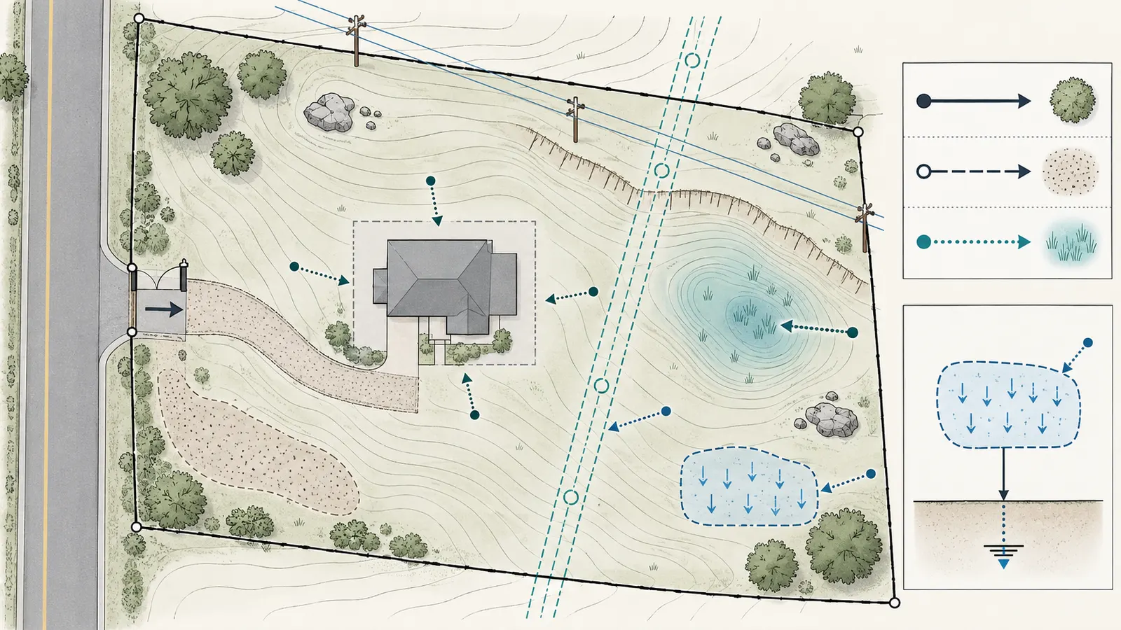
5. Handle the hard branches before you commit #
Before you commit, document every site signal that changes the investigation decision and require the proposal and report to state the evidence, limitation, responsible professional, and next handoff for that branch. A simple “soil test” can create false confidence when the site contains uncertainty that a generic allowance hides.
Branch: the house location is not fixed
If the footprint may move, ask the geotechnical professional whether to investigate a defined building envelope, compare candidate zones, or wait for a concept plan. A report tied to a survey point cannot automatically follow a house moved across a slope or onto fill. Provide the likely alternatives and explain what decision the report must support now: land purchase, schematic layout, foundation selection, or permit design.
The safe next step is to ask for a plan showing the investigation locations relative to a fixed boundary, property corner, road centerline, benchmark, or survey coordinate. If the report uses only approximate distances from an unmarked stake, ask how a future designer will confirm which location was actually investigated.
Branch: the site contains fill or disturbance
Fill is not one material. It can be engineered or uncontrolled, recent or old, clean or debris-containing, thin or deep, uniform or variable. A surface that looks compact does not prove the full thickness or quality. The investigation should identify the fill boundary as well as what lies beneath it where that distinction affects the foundation or grade plan.
Ask three separate questions: how will the field professional identify fill, how will the report distinguish observed material from assumed material, and what recommendation applies if fill extends below the planned foundation or grade change? If the house will sit partly on natural soil and partly on fill, request a direct explanation of how the transition is treated. If history suggests a tank, dumping, or contamination, ask whether a qualified environmental professional must be added. Do not ask a geotechnical report to silently answer an environmental question outside its scope.
Branch: the site is sloped
A slope adds more than a “steep” label. The relevant decisions may include house bearing, cut and fill, retaining walls, surface drainage, subsurface seepage, erosion, access for equipment, and the possibility that the proposed house changes how water moves. Pits can expose shallow materials at selected points, but a single pit cannot characterize a whole slope. Borings can provide depth information, but a few vertical points may not explain a lateral slip surface or drainage path.
Give the professional topographic information and the proposed grading concept. Ask where the uncertainty is greatest: slope break, house pad, uphill drainage, retaining line, or low toe. Ask what additional survey or stability analysis is outside the base geotechnical scope. The next handoff may be to a civil engineer for grading and drainage, a structural engineer for retaining design, or both.
Branch: rock is visible or suspected
Rock changes excavation, foundation, drainage, utility routing, and cost risk. An outcrop or shallow refusal is valuable evidence, but it is local evidence. Ask whether the report will distinguish rock refusal from a boulder, dense gravel, cemented soil, or obstruction, and whether the design needs rock quality or just depth-to-rock information. If rock excavation affects construction means and methods, ask how the report’s assumptions will be carried into bid documents without pretending the geotechnical professional has tested every future excavation path.
Where rock is obvious across a small area, the Texas Section ASCE practice says a site may be investigated and reported without drilled borings when outcrops or shallow test pits make the rock condition discoverable, provided the applicable depth requirements are satisfied. The statement is Texas guidance and still depends on professional judgment; it is not a homeowner authorization to omit borings. Texas guidance on shallow rock and method alternatives.
Branch: groundwater or seepage appears
Water observed during one visit is a time-stamped observation, not a complete seasonal groundwater model. Ask the report to state when water was observed, at what location and depth, under what weather conditions if known, and whether the observation may be affected by drilling or excavation. Ask whether additional measurements or monitoring are warranted for the foundation, basement, drainage, septic, or infiltration decision.
The Texas practice says the field log should record the presence or absence of free water, log depth when water is encountered, and take additional water-level measurements at the geotechnical engineer’s discretion. That supports a good handoff habit: do not accept “no groundwater” as a permanent site fact when the report only records “none observed on the day of exploration.” Texas Section ASCE on groundwater observations.
If an infiltration practice is proposed, the local stormwater program may care about the separation between the infiltration interface and groundwater or other limiting layers. Philadelphia Water Department guidance says limiting layers such as groundwater, bedrock, or impermeable soils within two vertical feet of an infiltration footprint are prohibited under that program and requires characterization beyond the interface. This is not a national stormwater or foundation rule; it shows why a drainage location and bottom elevation must be known before selecting the test location. Philadelphia Water Department’s local limiting-layer guidance.
Branch: access or utilities make a pit awkward
A pit can be visually excellent and operationally wrong if the excavator cannot reach the location without damaging a line, loading a structure, crossing a retaining edge, or working beneath overhead hazards. The professional may choose a boring, shift the location, use multiple smaller observations, or require utility and access work before field exploration. The question is not whether a machine can physically fit. It is whether the method can be performed safely and produce evidence at a location that represents the design decision.
OSHA guidance tells employers to contact utilities and assess underground lines and proximity to structures before excavation. Keep the fieldwork contractor and the engineer aligned: the engineer decides what evidence is needed; the field contractor plans means and methods within the applicable safety requirements; utility owners or locating services clarify known lines. A homeowner should not direct field personnel to “just move a few feet” without the professional deciding whether the new location still supports the investigation.
Branch: the stormwater footprint is elsewhere
Stormwater testing is a location problem. A foundation boring under a house may be excellent for foundation design and irrelevant to an infiltration practice in the rear yard. Conversely, a shallow pit at a proposed rain garden may show soil horizons but not answer a basement excavation question. Put both areas on the plan and ask the civil or stormwater designer to coordinate the test plan with the geotechnical professional.
Philadelphia’s guidance requires each proposed stormwater-management practice to be represented in a testing plan and says test locations should be tied to the proposed footprint, type, bottom elevation, depths, and dimensions. Again, Philadelphia controls only its program. The homeowner lesson is portable: make the water feature a named decision area before fieldwork. Philadelphia testing-plan requirements.
Branch: a test pit becomes deep
The hazard increases as an excavation gets deeper, but depth alone is not the only concern. OSHA’s safety card says protective-system selection considers soil classification, depth of cut, water content, weather or climate, surcharge loads, and other operations in the vicinity; its excavation requirements and guidance also address hazardous atmospheres, water accumulation, utilities, safe access, and inspections after rain or another hazard-increasing event. OSHA’s excavation hazard factors and OSHA’s trenching and excavation guidance support that safety boundary. Nearby structures remain a separate OSHA concern under the excavation standard. OSHA’s requirements for adjacent-structure stability apply to employee protection during excavation; they are not permission for a homeowner to direct field work. Philadelphia Water Department’s current test-pit guidance says that test pits greater than five feet deep need appropriate sloping and benching for access and testing in accordance with OSHA requirements. That is a Philadelphia-program-specific reminder, while OSHA’s construction standard supplies the broader employee-protection framework.
Keep the homeowner outside the fieldwork role. Do not enter to inspect the profile, take a photograph from the bottom, or retrieve an item. Ask the professional for photographs or diagrams if their normal report process includes them, and rely on their sealed or signed deliverable and safety procedures. If water accumulates, the sides crack, equipment approaches the edge, or weather changes, field personnel must handle the hazard under their safety plan; the homeowner should not make an on-site judgment.
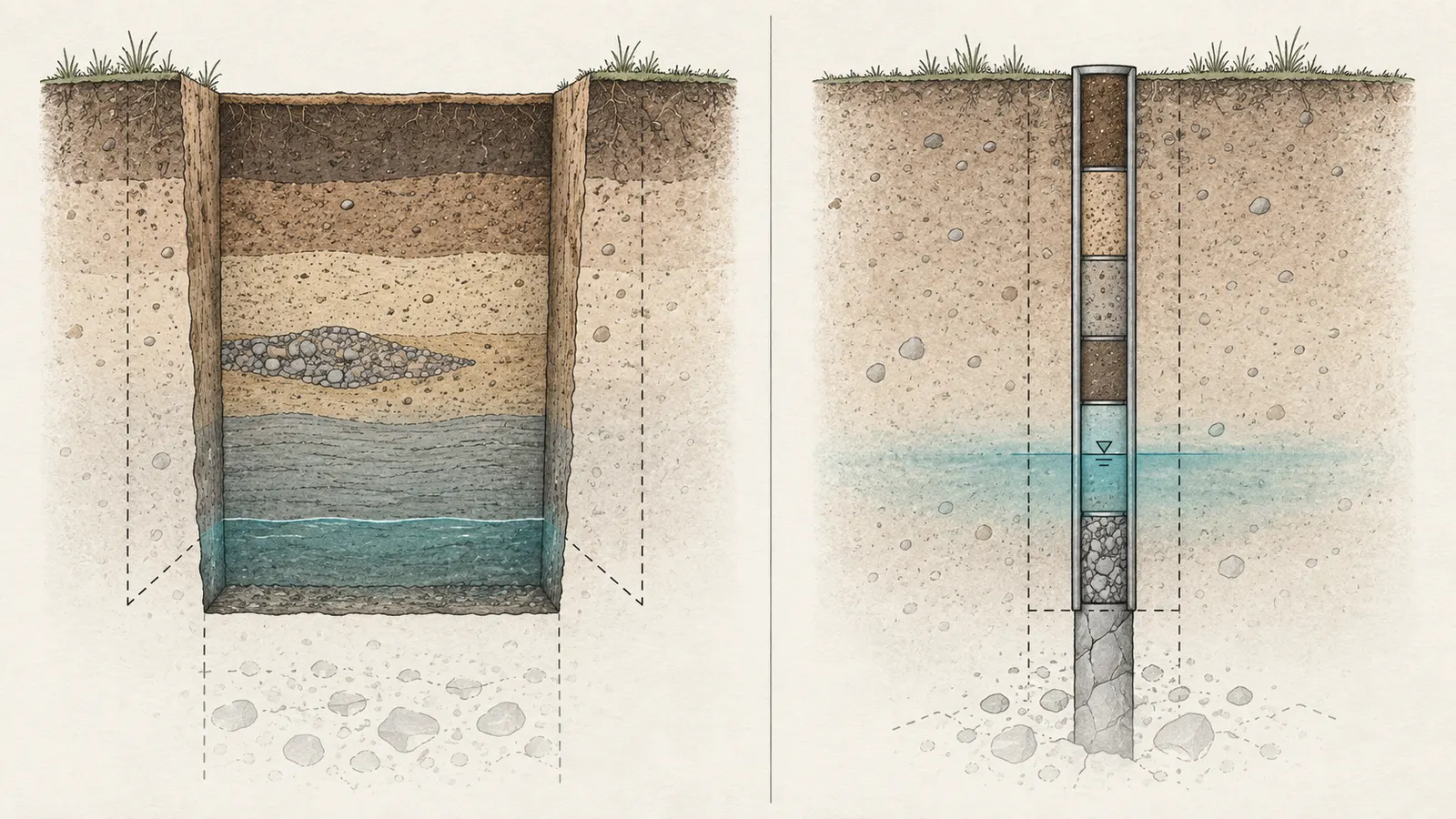
6. Review the proposal and report as a handoff, not a receipt #
A proposal is adequate for comparison when it tells you what decision the work supports, what the professional assumes, what field and laboratory work is included, what safety and access constraints apply, what the report will contain, what triggers additional work, and what remains outside scope. A report is adequate for the next handoff when the foundation or civil designer can identify the investigated areas, understand the evidence and limitations, and use the recommendations without guessing which house or grade the report assumed.
Proposal crosswalk
Use this crosswalk line by line. It is a homeowner review tool, not a professional standard of care.
| Proposal line to locate | Acceptable evidence of clarity | Follow-up if missing |
|---|---|---|
| Project description | Address, parcel, proposed house, foundation concept or alternatives, and current plan date | “Which house and grade assumptions are you pricing?” |
| Professional responsibility | Name and credentials or license role of the geotechnical professional; field contractor relationship; report signer | “Who interprets the field record and signs the recommendations?” |
| Investigation locations | Plan with pits/borings tied to boundary, survey, or fixed features | “How will the designer know exactly where the work occurred?” |
| Method | Test pit, hollow-stem auger or other boring, coring, sampling, infiltration test, monitoring, or supplemental method | “What decision does this method answer, and what can it not show?” |
| Depth and termination | Proposed depth basis, refusal or rock treatment, fill/compressible-material treatment, and authority-specific criteria if applicable | “What causes you to stop, extend, or add a location?” |
| Samples and observations | Material logging, sample type or interval, groundwater observations, laboratory testing, and photos or logs if included | “What record will be delivered to the foundation designer?” |
| Access and utilities | Access assumptions, utility locating responsibility, equipment limits, restoration, and safety boundaries | “What must be cleared or marked before mobilization?” |
| Stormwater coordination | Named infiltration or drainage footprints, bottom elevations, testing plan, and local program coordination | “Does this work support stormwater design, or only foundation design?” |
| Deliverable | Signed or sealed report as applicable, logs, location plan, results, recommendations, assumptions, limitations, and next-step triggers | “What is included in the report, and who can use it for design?” |
| Additional services | Unit rates or written authorization process for extra pits, borings, laboratory tests, monitoring, or redesign | “What observation triggers extra work and who approves it?” |
| Handoff meeting | Review with homeowner, architect, foundation designer, or civil engineer | “Who receives the report and confirms that the design assumptions match?” |
The Texas Section ASCE practice’s report list is a useful reference for the handoff structure. It identifies purpose and scope, authorization and limitations, project description and assumptions, investigative and laboratory procedures, results, logs and location plans, site characterization, foundation information and recommendations, and a professional engineer’s seal as minimum geotechnical report contents in its guidance. Local requirements may differ, but a proposal that promises only “soil test results” has not yet shown how the designer will receive the decision information. Texas Section ASCE report-content model.
What a useful log should let you reconstruct
You do not need to interpret the log like an engineer. You should be able to reconstruct the investigation:
- which hole or pit is which;
- where it was located relative to the plan;
- the ground elevation or reference used, if relevant;
- the method and equipment used;
- depth intervals and material descriptions;
- samples, tests, recovery, refusal, or obstructions recorded;
- water observed, not observed, or measured, with timing;
- changes in field conditions that affected the work;
- what was backfilled or restored;
- which conclusions are observations and which are professional interpretations.
If the report shows a boring log but not a location plan, ask for the plan. If it shows a pit photograph without depth or reference, ask how it relates to the recommendation. If it gives a design value without explaining the source layer or limiting condition, ask the foundation designer and geotechnical professional to coordinate before the value is used.
The stop rule for an inadequate handoff
Stop the foundation-design handoff when any of these conditions is true:
- the house location or foundation assumptions changed materially and the report has not been reviewed for applicability;
- a pit or boring stopped above known fill, compressible material, rock, water, or the design-relevant layer without an explicit professional conclusion;
- the field locations are not identifiable on the plan;
- the report describes a stormwater practice that was moved or resized after testing without confirming the test still applies;
- the report excludes groundwater, slope, retaining, infiltration, or environmental questions that the design is relying on;
- a local reviewer has requested a seal, method, sample record, or supplemental work that is absent;
- the report contains an unresolved limitation that the foundation designer cannot accept in writing;
- the proposal promised one deliverable but the received report provides only field notes or a lab result.
The next action is not automatically “order more borings.” Ask the geotechnical professional to identify the gap and the least-risk way to close it. That might be a new location, deeper work, monitoring, survey, laboratory testing, a different professional, a revised foundation concept, or a jurisdictional clarification.
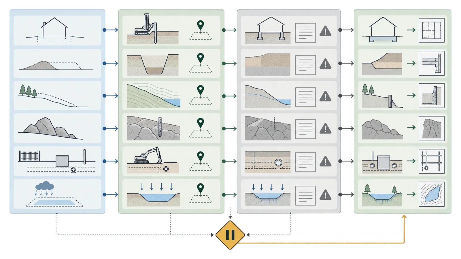
7. Work an illustrative branch from desktop evidence to the next decision #
Use the illustrative branch below to trace how one changed house or site input should reopen the method question and identify the next professional handoff; it demonstrates the matrix and does not select a field program for any real lot.
The following example is illustrative and modeled. It is not a field observation, quote, measurement, test result, or prediction about a real parcel. Its purpose is to show how the matrix works when the house and site inputs change. The numbers are planning inputs chosen to make the branch visible; they are not recommendations for a universal investigation program.
Example A: compact house, open access, uncertain old drive
Assume a homeowner is considering a vacant 0.6-acre lot in a U.S. county. The proposed house is one story over a crawlspace, approximately 1,850 square feet, with a 48-foot by 39-foot rectangular footprint. The site appears mostly level from the road. An aerial image and seller statement suggest an old gravel drive crossed the west half, but there is no grading record. The house location is a 30-foot-wide zone on the east half. A shallow swale is proposed along the south edge, but the stormwater design is not complete.
The homeowner’s initial temptation is to buy one cheap “soil test” for the house. The matrix changes the question:
Illustrative area calculation: footprint area = length × width. With the rounded planning dimensions, 48 ft × 39 ft = 1,872 sq ft. That is close to the stated approximate 1,850 sq ft, which shows why the dimensions and area should be treated as planning inputs rather than a survey. If the concept changes to 44 ft × 36 ft, the same formula gives 1,584 sq ft, about 15.4% less than 1,872 sq ft; at 52 ft × 42 ft, it gives 2,184 sq ft, about 16.7% more. This sensitivity changes the professional’s understanding of footprint and possible coverage, but it does not calculate the number, spacing, or depth of pits or borings. Fill, slope, rock, groundwater, access, foundation type, local requirements, and professional judgment control those decisions.
| Input | Initial interpretation | What must be confirmed |
|---|---|---|
| 1,850-square-foot one-story house | May be a relatively compact foundation decision | Actual foundation concept, concentrated loads, finished grade, and whether the footprint stays in the east zone |
| Old gravel drive | Potential disturbed or imported material | Whether it crosses the house, driveway, or swale and how its boundary is identified |
| Apparently level ground | Lower visible slope signal, not proof of uniform subsurface conditions | Drainage, fill, wet season behavior, and any hidden grade change |
| Open road access | Pit may be physically feasible | Safe location, utility clearance, equipment reach, and restoration |
| South swale not designed | Not ready for one shared test assumption | Final swale or infiltration footprint, bottom elevation, and local stormwater rules |
The proposal request should ask the geotechnical professional to review the house zone and old-drive transition, state whether exploratory pits, borings, or both are appropriate, log any fill and water observations, and explain whether the work supports the preliminary foundation concept. It should separately ask the civil or stormwater designer whether the swale needs its own characterization or infiltration test.
Suppose the professional proposes two shallow test pits across the east-zone footprint and one boring near the old-drive transition. That may be reasonable, unreasonable, or incomplete depending on the actual site and local requirements; the homeowner cannot approve it from the count alone. The homeowner can ask:
- Which decision does each location support?
- Does the boring extend below the suspected drive fill and into underlying material?
- Are the pits located so they compare the likely house center and edge or the suspected transition?
- What happens if the pit shows water, debris, rock, or a deeper fill boundary?
- Does the report distinguish the proposed house assumptions from the future final plan?
- Is the swale in the scope, and if not, who is responsible for adding that decision?
The next decision after fieldwork is not simply “soil good” or “soil bad.” It is whether the current foundation concept can proceed, whether the house zone needs redesign or grade change, whether the stormwater feature needs separate work, and whether the report is complete enough for the foundation designer.
Example B: same house, slope and basement added
Now change only two inputs: the homeowner wants a walkout basement, and the house moves to a 12 percent slope near the uphill property line. The old-drive history remains. Those changes increase the importance of deeper excavation, groundwater, lateral variability, cut-and-fill transitions, retaining conditions, and access. A shallow pit program that might have been useful for the original crawlspace concept cannot be assumed to support the basement design.
The method request should be reopened. Ask the professional to define:
- the building and basement excavation envelope;
- the topographic references and proposed finished grades;
- the uphill drainage and possible seepage zone;
- locations representing the house pad, cut face, retaining line, and transition to fill;
- whether borings, rock observations, groundwater monitoring, or slope analysis are needed;
- which excavation, temporary support, or dewatering questions are outside the report;
- how the report will be updated if the basement moves.
This is why the proposed house matters more than a generic lot size. A change in foundation type can change the evidence decision even when the parcel has not changed.
Example C: add a stormwater infiltration area
Finally, assume the civil designer proposes a small infiltration practice at the south swale. The practice has a preliminary bottom elevation 3 feet below existing ground. The exact location is still flexible. The homeowner should not ask the geotechnical professional to “use the house pits for the swale” without the stormwater designer confirming that the test locations, depths, and method support the local program.
Philadelphia’s guidance illustrates the structure of that coordination: the testing plan identifies the proposed practice, footprint, bottom elevation, test locations, method, count, depth, and dimensions. It allows exploratory test pits and hollow-stem auger boreholes for characterization, describes the visual advantage of pits, and uses different program-specific depth and infiltration-testing requirements for pits and borings. In this example, those exact Philadelphia requirements do not apply unless the project is in Philadelphia and within the relevant program. The transferable action is to create a separate, location-specific stormwater branch. Philadelphia’s testing-plan and method guidance.
Sensitivity: what changes the choice
The matrix can be stress-tested by changing one input at a time while holding the others constant. That is a qualitative sensitivity analysis, not a measured performance study.
| Changed input | Likely direction of method question | Why the handoff changes |
|---|---|---|
| House moves 40 feet toward a wet low point | Add or relocate evidence near the low point; do not simply reuse the old conclusion | Location is part of what the report supports. |
| Crawlspace becomes basement | Ask about deeper conditions, water, rock, excavation, and grade | Foundation decision now includes below-grade work. |
| Flat pad becomes cut-and-fill slope | Ask about transitions, drainage, retaining, and representative points | The project creates more than one ground condition. |
| Open access becomes 5-foot gate | Ask whether a pit is feasible and whether a boring or alternate method is safer | Physical access can control method without proving that a boring is technically superior. |
| Suspected old tank appears in records | Add environmental and utility questions | A geotechnical scope may not answer contamination or tank closure. |
| Stormwater feature moves 60 feet | Reconfirm whether any testing applies to new location | A nearby test is not automatically representative for the new footprint. |
| Wet-season construction becomes year-round occupancy | Ask how water observations and seasonal limits are reported | A single dry-day observation may be an important limitation. |
The point of sensitivity is not to predict the answer. It is to reveal which assumptions a proposal depends on. If a small change makes the proposal meaningless, the proposal should name that dependency.
8. Make the final handoff and next decision explicit #
You are ready to hand the investigation to foundation or site designers when the professional has tied the work to the current plan, documented locations and methods, stated observations and limitations, addressed the material site signals, and identified the decisions the report can support. You are not ready merely because a machine visited the lot or because a laboratory printed a number.
The handoff sequence
Use this sequence in your project log:
- Freeze the current decision brief. Record the address, jurisdiction, plan date, house footprint, foundation alternatives, grades, drainage areas, and known uncertainties.
- Confirm the local path. Ask the relevant building, stormwater, septic, or floodplain authority what current adopted requirements apply. Save the answer and source.
- Send the site packet. Include survey, plan, history, photo log, constraints, utility information, and decision questions.
- Compare scopes by outcomes. Record method, locations, depth basis, sampling, groundwater, lab work, supplemental triggers, safety/access assumptions, report contents, and handoff.
- Authorize in writing. Identify who can approve added work and how changes are documented.
- Keep out of the hazard zone. Let qualified field personnel control excavation, drilling, utility coordination, and protective systems.
- Receive and reconcile the report. Check that the location plan and assumptions match the current project.
- Hold a handoff review. Have the geotechnical professional and foundation or civil designer identify what is resolved, what is limited, and what must happen next.
- Update the house decision. Choose whether to proceed with the foundation concept, redesign the location or grade, add work, or stop before spending on detailed design.
A homeowner verification checklist
Before you treat the package as ready for design, check each line and record “yes,” “no,” or “not applicable” with an explanation.
- The parcel, city, county, and state are named.
- The current house footprint and foundation assumptions are dated.
- The investigation plan identifies locations relative to a survey, boundary, or fixed feature.
- The proposal and report identify the professional responsible for interpretation and sign-off.
- Test pits, borings, or both are connected to specific decisions.
- The method’s blind spots are stated, including areas or depths not represented.
- Fill, disturbance, slopes, rock, drainage, seepage, vegetation, and old construction were considered where relevant.
- Utilities, access, structures, easements, and overhead hazards were addressed before fieldwork.
- Field logs state material observations and identify samples or tests.
- Water was recorded as observed or not observed, with timing and limits.
- Laboratory work is named where the recommendation relies on it.
- Stormwater or infiltration areas are shown separately if they are part of the design.
- The applicable local authority and code or program source are identified.
- The report states purpose, scope, assumptions, limitations, procedures, results, recommendations, and next steps.
- A changed footprint, grade, or foundation concept has been reviewed for report applicability.
- Unresolved conditions have a named owner and next action.
If several boxes are “no,” do not solve the problem by asking for more tests at random locations. Return the package to the responsible professional and ask which missing item affects the design decision. More data is not automatically better data; representative location, method fit, documented limits, and professional interpretation matter.
The next decision tree in plain language
If the report supports the current foundation concept, the next handoff is to foundation design with the report, plan, logs, recommendations, and limitations attached. If it supports only a preliminary concept, the next handoff is to refine the house and request a scope review before final design. If it finds fill, water, rock, slope, or variability that changes the decision, the next handoff may be supplemental geotechnical, civil, structural, environmental, or jurisdictional work. If the report cannot identify where or how evidence was collected, stop and resolve the record before design.
If the site is in New York City, verify the actual current Administrative Code and plan-review requirements rather than borrowing a rule from elsewhere. Section 27-664 is a local example that shows both the possibility of a one-for-one test-pit substitution and the conditions attached to a local depth exception; it is not a national shortcut. If the project is in Philadelphia and uses a stormwater-management practice, follow the Philadelphia Water Department’s current testing-plan, soil-characterization, infiltration, and review requirements rather than treating this article’s comparison as the program rule.
What to send the foundation designer
Send one controlled package, not a loose collection of screenshots:
- current site and foundation plans;
- geotechnical report and signed or sealed pages as applicable;
- investigation location plan;
- pit and boring logs;
- laboratory results and test methods, if included;
- groundwater and seepage observations with timing;
- photos or field records provided by the professional;
- list of assumptions and limitations;
- local authority comments or requirements;
- stormwater or septic testing records if relevant;
- a change log showing any footprint, grade, or foundation revision since fieldwork.
Ask the foundation designer to reply with the assumptions they used and any gap that prevents design. This closes the loop between the report and the design rather than treating delivery as acceptance. The Texas Section ASCE practice’s three-phase model—geotechnical information, foundation design, and documented construction observation—illustrates why the report is a handoff in a longer responsibility chain, not the entire foundation process.
The one-sentence request to a geotechnical professional
You can begin a professional conversation with a request like this:
Please review the attached current site and house assumptions and propose a geotechnical investigation that supports foundation selection and identifies any separate work needed for fill, slope, rock, groundwater, utilities, drainage, or stormwater locations; show the proposed locations and depth basis, describe the evidence and report handoff, state limitations and change triggers, and identify which local requirements you verified.
That sentence does not prescribe test pits or borings. It gives the professional the decision, inputs, constraints, and deliverable that make a method choice meaningful.
The best investigation is therefore not the one that wins a narrow comparison. It is the one whose method, location, depth, observations, safety plan, and report all line up with the house you are actually about to design. Use test pits when visual, shallow, accessible evidence is the right answer and the professional can perform them safely. Use borings when depth, constrained access, sampling, water, rock, or a local requirement makes them the better evidence path. Use supplemental work when the decision extends beyond either method. Then stop, verify, and make the next handoff explicit before foundation design spends money on assumptions the site investigation never tested.
Cite this guide
Brictale. “How to Choose Test Pits or Borings for a Vacant-Lot House Soil Investigation.” Published 2026-09-22; updated 2026-09-22.
https://brictale.com/build/land/choose-vacant-lot-test-pits-borings-soil-investigation-before-foundation-design · Read the Markdown version
Original contribution: Vacant-lot investigation method matrix and proposal crosswalk. A homeowner-facing way to turn the proposed house, visible site signals, and stormwater or access constraints into questions for a qualified geotechnical professional without selecting engineering depths alone.
Sources and scope
Evidence behind this page
- The Texas Section ASCE recommended practice describes an engineered foundation as having geotechnical information supplied by a licensed engineer, foundation design performed by a licensed engineer, and construction observed with written documentation; it says a geotechnical investigation and report should be completed by a geotechnical engineer before foundation design.
Recommended Practice for the Design of Residential Foundations, Version 2, Texas Section ASCE
Texas Section ASCE recommended practice adopted in 2007; professional guidance, not a national building code or universal legal requirement.
Accessed · Link to this claim - The Texas Section ASCE recommended practice says an exploration program should consider vegetation, fill depth, drainage, seepage areas, slopes, fence lines, old roads or trails, man-made construction, seasonal weather cycles, and other conditions affecting foundation performance.
Recommended Practice for the Design of Residential Foundations, Version 2, Texas Section ASCE
Texas Section ASCE recommended practice, section 4.1; used here as a professional planning model rather than national law.
Accessed · Link to this claim - The Texas Section ASCE recommended practice allows exploration by drill rig or test pit when depth requirements are satisfied, and says an obviously rocky site may be investigated without drilled borings when rock outcrops or shallow test pits make the condition discoverable.
Recommended Practice for the Design of Residential Foundations, Version 2, Texas Section ASCE
Texas Section ASCE recommended practice, section 4.1; the qualified engineer still sets the applicable program for the site and jurisdiction.
Accessed · Link to this claim - For unknown but believed uniform subsurface conditions, the Texas Section ASCE recommended practice gives maximum 300-foot boring centers for subdivisions and says one boring may be sufficient for an isolated simple residence under 2,500 square feet, while fill, large footprints, steep slopes, varying geology, fault zones, or transitions may require more; it also gives example minimum depth and sampling intervals.
Recommended Practice for the Design of Residential Foundations, Version 2, Texas Section ASCE
Texas Section ASCE recommended practice, section 4.1; examples and guidance for Texas residential foundation practice, not a national minimum or a homeowner-selected scope.
Accessed · Link to this claim - The Texas Section ASCE recommended practice lists purpose and scope, limitations, project description and assumptions, investigative and laboratory procedures, results, boring logs and location plans, site characterization, foundation information and recommendations, and a professional engineer seal as minimum geotechnical report contents.
Recommended Practice for the Design of Residential Foundations, Version 2, Texas Section ASCE
Texas Section ASCE recommended practice, section 4.3; report-handoff model, not a universal reporting mandate.
Accessed · Link to this claim - New York City Administrative Code section 27-664 states that test pits may be substituted for borings on a one-for-one basis while observing applicable requirements for depth, sample numbers, reported data, and sample disposition, with stated exceptions for spoon use, driving resistance, and rock cores.
New York City Administrative Code § 27-664 Test pits
New York City, New York, Administrative Code chapter 1 building code; a local example only, not national law.
Accessed · Link to this claim - New York City Administrative Code section 27-664 provides a specific test-pit depth exception for certain one-story buildings and one- or two-family residences no more than two stories high when supported on specified satisfactory bearing materials; it refers to four feet below the deepest footing excavation or a four-foot minimum in the stated case.
New York City Administrative Code § 27-664 Test pits
New York City, New York, Administrative Code section 27-664(b); not a rule for other cities, counties, states, or unverified site conditions.
Accessed · Link to this claim - Philadelphia Water Department guidance requires a testing plan for infiltration and soil characterization that identifies proposed stormwater-management footprints, their type and bottom elevation, test-pit and boring locations, test counts, test types, depths relative to existing ground, and dimensions from boundaries or structures.
3.3 Infiltration Testing and Soil Assessment for SMP Design, Philadelphia Water Department
Philadelphia Water Department stormwater-management-plan design guidance; applies to the Philadelphia program and comparable planning logic, not national residential foundation law.
Accessed · Link to this claim - Philadelphia Water Department guidance says an exploratory test pit allows visual observation of soil horizons and overall soil conditions horizontally and vertically in that portion of the site, while soil-boring horizons are observed from extracted material and therefore have limited in-situ visual observation.
3.3 Infiltration Testing and Soil Assessment for SMP Design, Philadelphia Water Department
Philadelphia Water Department stormwater-management-plan design guidance, section 3.3.2; method distinction used here as a bounded technical comparison.
Accessed · Link to this claim - Philadelphia Water Department guidance strongly recommends test pits over soil borings unless structures, utilities, space constraints, depth, or similar conditions make excavation impractical; it identifies hollow-stem auger boreholes as the alternative for those constraints.
3.3 Infiltration Testing and Soil Assessment for SMP Design, Philadelphia Water Department
Philadelphia Water Department stormwater-management-plan design guidance; preference is program-specific and not a national ranking of methods.
Accessed · Link to this claim - Philadelphia Water Department guidance specifies that one test pit for each stormwater-management practice must extend at least four feet below the proposed infiltration interface or stop at bedrock or fully saturated conditions, while its constrained-boring pathway calls for borings ten feet below the interface or to auger refusal with continuous split-spoon sampling; these are program-specific requirements.
3.3 Infiltration Testing and Soil Assessment for SMP Design, Philadelphia Water Department
Philadelphia Water Department stormwater-management-plan design guidance, sections 3.3.2 and 3.3.3; not a residential foundation depth rule outside that program.
Accessed · Link to this claim - USDA Natural Resources Conservation Service says soil surveys identify and map soil characteristics and can include physical, chemical, and engineering properties such as depth, texture, particle-size distribution, plasticity, permeability, shrink-swell potential, corrosion, and erodibility; its Web Soil Survey provides public access to the mapped data.
Soil Facts, Natural Resources Conservation Service
USDA NRCS national soil-survey education and data context; mapped soil information is screening evidence and does not replace a site-specific engineering investigation.
Accessed · Link to this claim - USDA NRCS explains that soil surveys provide useful planning information, while onsite investigation is needed for intensive uses of small areas.
From the Surface Down: An Introduction to Soil Surveys, Natural Resources Conservation Service
USDA NRCS educational guidance in the cited introduction to soil surveys; used to bound desktop soil maps as preliminary evidence rather than a foundation clearance.
Accessed · Link to this claim - OSHA's construction excavation standard generally requires employees in an excavation to be protected from cave-ins by an adequate protective system, with narrow exceptions for stable rock and excavations less than five feet deep when a competent person finds no cave-in indication; the rule also addresses sloping, benching, and shielding.
29 CFR 1926.652 Requirements for protective systems, Occupational Safety and Health Administration
U.S. OSHA construction standard for employee protection; it does not authorize a homeowner to enter an excavation or define a geotechnical investigation scope.
Accessed · Link to this claim - OSHA's trenching and excavation guidance identifies standing water and hazardous atmospheres as risks and tells employers to plan ahead by contacting utilities and assessing proximity to underground lines and structures before excavation.
Trenching and Excavation, Occupational Safety and Health Administration
U.S. OSHA construction safety guidance; safety planning for professionals and employers, not permission for homeowner field work.
Accessed · Link to this claim - FHWA subsurface-investigation guidance says boring logs should record the investigation location and elevation, deviations from planned locations, strata depths, sampler type and recovery, sampling intervals, drilling operation, resistance, water-level observations with dates and times, and boring closure; it says laboratory results are combined with boring logs and other field information to develop profiles, and cautions that interpretation between borings becomes questionable where soil or rock conditions vary, warranting more borings or geophysical methods when reliable continuity is needed.
Federal Highway Administration subsurface-investigation guidance for transportation applications; the article uses its recordkeeping and variability principles as bounded technical guidance, not as a residential specification or required test program.
Accessed · Link to this claim - OSHA's trenching and excavation safety card says selecting an excavation protective system requires consideration of soil classification, depth of cut, water content, weather or climate, surcharge loads, and other operations in the vicinity; it also identifies safe access and egress, utility location, hazardous-atmosphere testing, and inspections after rain as safety controls.
Trenching and Excavation Safety, Occupational Safety and Health Administration
U.S. OSHA construction safety guidance and standards for employee protection; it does not authorize homeowner entry or direct a geotechnical investigation scope.
Accessed · Link to this claim - OSHA's excavation requirements address stability of adjoining buildings, walls, and other structures, including support systems or other approved protections when excavation could endanger them, and separately address equipment or materials that could fall or roll into an excavation.
29 CFR 1926.651 Specific Excavation Requirements, Occupational Safety and Health Administration
U.S. OSHA construction standard for employee protection; it does not authorize homeowner entry or define the geotechnical investigation scope.
Accessed · Link to this claim