How to Assess Private-Well Feasibility for a Vacant Lot Before Buying
A US buyer’s sequence for checking public-water status, well and septic siting, local permits, access, records and contract conditions before closing.
The short answer
Before buying, prove the parcel’s actual water-service path with the local building and health authorities, reserve a workable well-and-septic layout, review nearby well records as clues rather than proof, and get a licensed professional’s written feasibility opinion. If a gate remains unresolved, make the purchase contingent on written approval or stop before the commitment becomes nonrefundable.How to Assess Private-Well Feasibility for a Vacant Lot Before Buying
Before buying, prove the parcel’s actual water-service path with the local building and health authorities, reserve a workable well-and-septic layout, review nearby well records as clues rather than proof, and get a licensed professional’s written feasibility opinion. If a gate remains unresolved, make the purchase contingent on written approval or stop before the commitment becomes nonrefundable.
The decision is whether to keep investigating, condition the purchase, or stop #
You should keep investigating a vacant lot only when the parcel has a plausible legal water path, a physical area for both water and wastewater, usable access for the professionals who must inspect and drill, and a written next verification that can happen before your purchase risk becomes irreversible. A listing that says “well and septic,” a neighbor’s productive well, or a groundwater map is not that verification. The decision is not “is there water somewhere underground?” It is “can this specific parcel receive an approved domestic water source, in the actual jurisdiction, on a location that still leaves room for a compliant home and wastewater system, at a risk and cost you are willing to accept?”
This is a United States guide with a deliberately narrow legal promise: it gives you a research and handoff sequence, not a national setback table. EPA explains that private-well construction depends on local geologic and groundwater conditions and directs owners to the state licensing agency, local health department, or local water-system professional for site-specific information. Every distance, lot-size rule, public-water restriction, permit step, testing threshold, and professional requirement below is labeled to the actual authority that publishes it. The Illinois and Virginia figures are examples of state rules. The lot-size and application sequence are King County, Washington examples. They are not portable rules for a different county.
Compact originality brief
Current answers usually explain what an existing private well is, list broad siting cautions, or tell an owner to hire a driller. The missing decision is what a buyer should prove before closing when the lot has no well and the seller’s description is only a possibility. The original contribution here is a Private-well feasibility ledger: a parcel-level worksheet that connects public-water status, local approval gates, a reserved well-and-septic layout, nearby records, access, responsibility, confidence, and the next verification. You can check it by asking whether every “yes” has a source, a jurisdiction, a named responsible party, and a document or field action that could change the answer.
The ledger is intentionally an evidence trail rather than a score. A parcel does not become feasible because it earns six green cells. It becomes a candidate for the next professional review when its unresolved cells are visible, bounded, and contractually protected. A red cell can mean “stop,” “ask the authority,” “redesign,” or “condition the purchase”; the meaning belongs in the next-action column, not in an invented confidence number.
Private-well feasibility ledger
The following is a reusable worksheet. Copy it into your due-diligence file and fill it with the parcel number, legal description, jurisdiction, dates, names, and links that apply to the lot. “Confidence” means confidence in the record or observation, not confidence that the well will produce water. “Open” is a valid result.
| Gate | Inputs to record | What the evidence can prove | What it cannot prove | Responsible party | Confidence | Next verification |
|---|---|---|---|---|---|---|
| Parcel identity | Parcel number, legal description, lot area, lot-creation date, municipality or county, zoning | You are checking the correct land and rules | That the lot is buildable or has water rights | Buyer and title professional | High only when matched to recorded documents | Confirm with assessor, recorder, planning office, and title report |
| Public-water status | Utility name, service map, pressure or connection letter, available easements, connection deadline | Whether a public source may be available or required | That private well is allowed merely because the main is far away | Buyer, utility, building authority | Open until written | Request a parcel-specific availability or nonavailability response |
| Health authority gate | State and county health office, application type, pre-application response, fees, review path | Which authority reviews source location, sanitation, samples, or construction | That an unissued permit will be approved | Buyer with local professional | Open until written | Ask for written confirmation of the application and decision sequence |
| Well location | Scaled plan, contours, drainage, roads, structures, easements, contamination sources | Whether a candidate point can be reviewed against local separation rules | Yield, chemistry, or final construction success | Septic designer, civil or water professional, health authority | Medium before site visit | Mark a primary and backup point; obtain local siting review |
| Wastewater layout | Soil/site evaluation, septic reserve area, repair area, house footprint, driveway | Whether water and wastewater can coexist on the parcel | That a conceptual sketch is an approved septic design | Qualified septic designer or local health authority | Open before site work | Commission the required site evaluation or design |
| Drilling access | Gate width, turning radius, overhead wires, slopes, surface, staging, easements | Whether a driller can reach the candidate point safely and lawfully | Drilling price, depth, yield, or no-failure outcome | Buyer, driller, access-right holder | Medium only after site review | Have the driller inspect access and state assumptions in writing |
| Nearby well records | Well logs, completion reports, depth, casing, reported yield, dates, location quality | Evidence of what was reported in nearby construction | Your parcel’s yield, quality, or legal approval | Buyer, geological or water professional | Low to medium depending on record | Compare multiple records and ask the authority how records are indexed |
| Water quantity | Local test requirements, seasonal concerns, household demand, storage concept | The test or standard the authority uses after construction | A map or neighbor’s result predicting your well | Driller, pump professional, authority | Open before drilling | Put the test, acceptance, and fallback in the feasibility scope |
| Water quality | Required analytes, lab certification, collection method, known contaminants | Whether a collected sample meets the named test or threshold | Future stability or every possible contaminant | Certified lab and water professional | Open before drilling | Ask the health authority and lab what to test and when |
| Ownership and maintenance | Covenant, easement, pump power, access, abandonment duty, records | Who must preserve access and operate the system | That future owners will understand it without documents | Buyer, title professional, authority | Open until recorded | Review title language and future maintenance responsibilities |
| Purchase protection | Inspection period, feasibility deadline, notice method, refund and extension terms | Your contractual ability to investigate or leave | That a seller or professional will accept a change | Buyer and real-estate attorney | Open until signed | Have the attorney draft a jurisdiction-appropriate condition |
Method: enter the parcel record first, then record each source-backed gate as a separate row with its jurisdiction, evidence, responsible person, confidence and next verification; treat an unresolved gate as a contract question rather than a green light. This method prevents a common category error: treating evidence that describes the ground, another property, or an authority’s review process as if it were an approval for your lot.
Limitations: this ledger is an illustrative decision aid, not a yield prediction, water-quality result, engineering report, permit, septic design, legal opinion or guarantee that a parcel can support a home. It does not replace a title review, land survey, soil evaluation, septic design, well-site inspection, driller visit, laboratory analysis, or written determination from the relevant authority. Its job is to make the handoffs visible early enough that you can decide what to buy, what to condition, and what to abandon.
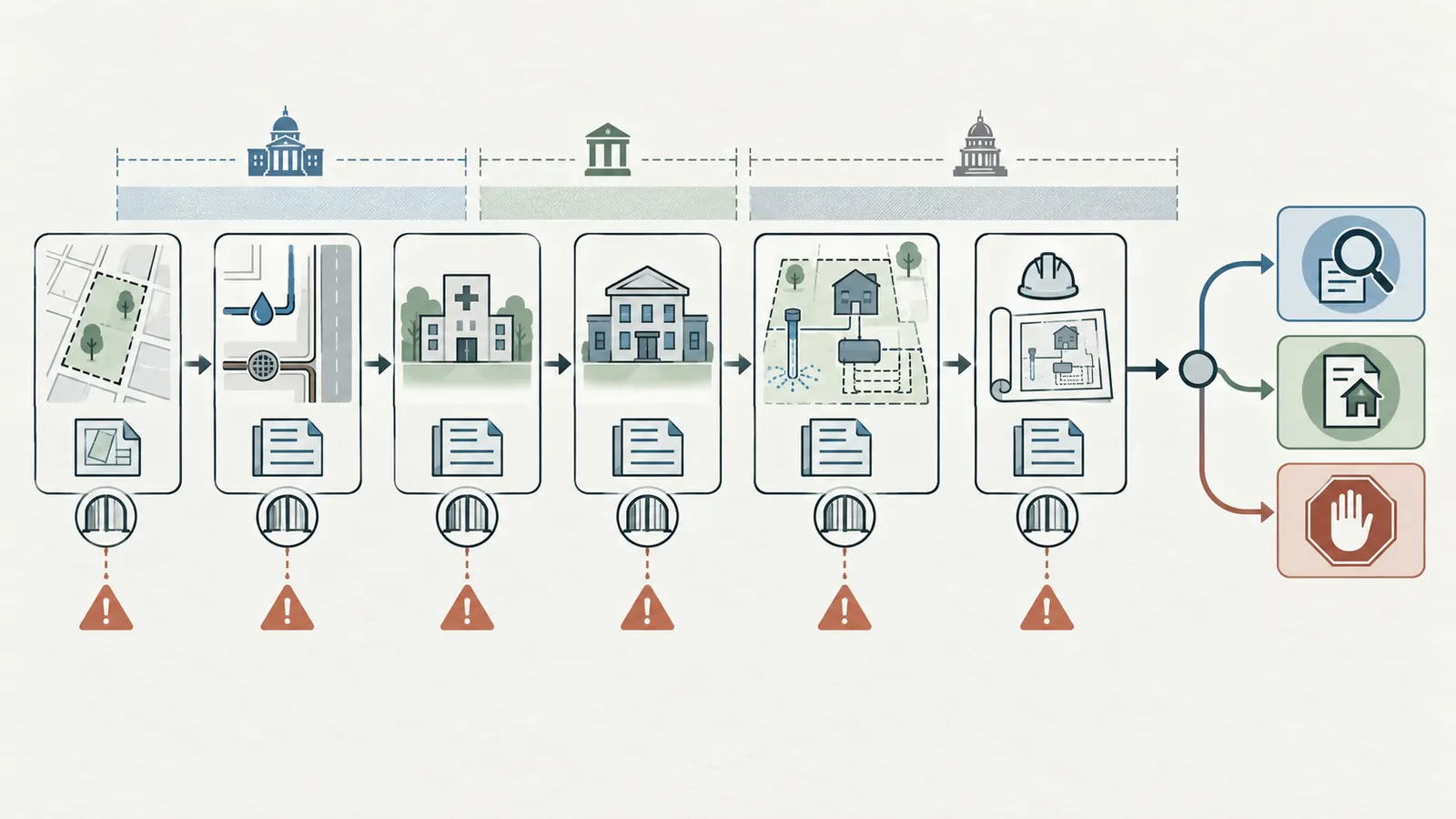
The safest next decision after filling the ledger is not to order drilling. It is to classify every row as verified, locally pending, professionally pending, contradicted, or outside the authority’s scope. If the public-water row is contradicted, stop treating a private well as the default. If the well and septic rows cannot coexist on a scaled plan, stop unless a qualified designer identifies a compliant alternative. If the only positive evidence is a nearby well, keep investigating but do not waive the condition.
Start with the parcel, public-water status, and authority map #
Before researching groundwater, identify the parcel’s actual decision-makers and determine whether a public-water connection is available, required, or legally preferred. The first written answer should come from the utility and the jurisdiction that controls residential development, not from the listing, a driller’s general estimate, or a map layer.
Build the authority map
A vacant lot can involve several authorities that answer different questions. The state may license drillers and publish construction standards. A county or district health department may approve a well location, septic system, sample, or inspection. A city or county planning/building department may decide whether the water source supports a dwelling. A water utility may control connection availability, service boundaries, capacity, meters, or connection obligations. A recorder or title professional may control how an easement or covenant is established in the land records. These roles overlap in the homeowner’s mind but not necessarily in law.
Create a one-page authority map before you call. Use the parcel number and legal description, because a street address may be absent or shared. Record the office, web page, phone number, person or intake queue, date contacted, exact question, answer, document promised, and whether the answer is informal or an issued decision. Ask each office to name the next office rather than assuming the first responder owns the entire process.
The first call is usually the local planning or building authority: “For this parcel and the proposed single-family residence, what water sources are permitted or required before a building permit can be issued?” Ask whether the answer changes because the parcel is inside city limits, in a special groundwater-management area, in a recorded subdivision, within a utility service area, or subject to a prior plat condition. Ask what document proves the answer: a water-availability letter, utility will-serve letter, certificate, building preapproval, health approval, or another named form.
The second call is the water utility, if one serves or borders the parcel. Ask whether the lot is inside the service area, whether a connection is physically available at the frontage, whether a connection is mandatory, whether a meter or main extension is required, whether a capacity or availability letter expires, and whether the service area includes a private-well prohibition. “The nearest main is 1,000 feet away” is not a legal answer. “The utility confirmed in writing that no connection is available and the county accepts a private source for this parcel” is materially better evidence.
The third call is the local or district health authority. Ask which program reviews the private-well location, the onsite sewage system, or both; whether pre-application review is available; who may submit the application; whether an existing or proposed house plan is required; what map scale and field markings are required; what separation distances apply; and whether a well location must be approved before drilling. Do not ask only, “Can I drill a well?” Ask, “What must be approved before this parcel can use a private well as the domestic source for a permitted home?”
The fourth call is to the state water-well licensing or records office. Ask how to verify a driller’s current license, how to retrieve nearby completion reports or well logs, whether the database is complete, and what fields are self-reported or estimated. A records office can tell you how to read its records; it usually cannot certify that your parcel will match a neighboring aquifer or that a future well will meet your county’s development standard.
Separate four different conclusions
Use these labels in your notes:
- Legal eligibility: the authority says the parcel may pursue the private-well path under the applicable rule.
- Site feasibility: a qualified person identifies at least one location that can coexist with the home, driveway, septic system, reserve area, easements, drainage, and contamination controls.
- Construction prospect: a licensed driller says the site can be approached and gives a bounded scope or method for drilling and testing.
- Operational acceptance: after construction, the well passes the jurisdiction’s required inspection, testing, recording, and water-source approval steps.
The first does not establish the second. The second does not establish the third. The third does not establish the fourth. Virginia’s regulations provide a useful illustration: they connect permits, completion statements, inspections, and operation, but explicitly say that an inspection statement does not warrant or guarantee operation for a specified period. Read the Virginia regulation’s inspection and warranty language before treating any approval document in any jurisdiction as more powerful than it is.
What to ask for in writing
Request answers in a form you can attach to the ledger. A concise email can be enough for an initial gate if it identifies the parcel and the authority, but a formal letter or issued determination is stronger when the answer affects a contract. Ask the responder to distinguish “not reviewed,” “not available,” “not allowed,” “allowed if,” and “approved.” Those terms lead to different next decisions.
Keep the exact rule citation and the date. A county webpage can change; a permit can expire; a lot can have a prior approval that is tied to a former building permit or an old site plan. If the office says, “Your professional must submit this,” record the professional type and the named application. If it says, “This lot is too small,” record whether the rule is based on current area, lot-creation date, plat status, a public-water requirement, a covenant, or another fact.
Early stop conditions
Stop or pause before paying a nonrefundable deposit when any of these is true:
- The seller cannot establish the parcel identity or legal access.
- The utility says connection is required, but no connection path or cost responsibility is documented.
- The development authority will not recognize a private well as an acceptable domestic source.
- The health authority cannot identify the application path because the proposed use or lot status is unresolved.
- No well point and septic area can fit on the same scaled plan.
- The only evidence is a map, listing statement, verbal promise, or neighboring well.
- The seller refuses reasonable access for a professional site review during the contingency period.
These are not judgments about the land’s groundwater. They are failures of the decision process. A good parcel can still be a bad purchase if the unresolved risk cannot be investigated within the contract window.
Check the public-water gate before reserving a well #
Do not treat private-well feasibility as the default alternative to a distant water main. First document whether public water is available, required, or unavailable for this parcel, because a health department’s willingness to review a well may not give the building authority permission to use it.
Availability is parcel-specific
Public-water status has at least five parts: service-area boundary, physical main location, right to connect, capacity or availability, and development requirement. A lot can be adjacent to a main but not have a simple connection because the main is on another frontage, an easement is missing, a crossing is restricted, the utility requires an extension, or the local development code requires connection when service is available. Conversely, a parcel can be outside a mapped service area but still need a formal nonavailability determination before a private source is considered.
Ask for the utility’s actual document name. Examples include a will-serve letter, certificate of water availability, no-service letter, service-area confirmation, connection estimate, or predevelopment response. Do not invent the name if the office uses another form. Record whether the document is based on an address, parcel number, or a proposed subdivision; the latter may not apply to a standalone lot.
King County, Washington demonstrates why this gate comes first. Its new individual/private-well guidance starts with a lot that has no previously approved source and cannot connect to a Group A or Group B public system. It also says the jurisdictional building-permitting authority ultimately decides whether a private well may support land development. The King County application guide states those prerequisites and the building-authority boundary. That is a local example, but the reasoning is widely useful: a well application is not automatically a residential water-availability approval.
Ask the utility these questions
Use a written checklist rather than an informal “is water nearby?” conversation.
- Is the parcel inside the utility’s service area as of the response date?
- Is a public main at a frontage or easement that can legally serve the parcel?
- Is connection mandatory for a new residence, even if a private well is technically possible?
- If connection is possible, what work, easements, fees, extension, pressure equipment, or off-site approvals are required?
- Does the answer depend on a future subdivision, accessory dwelling, or shared system?
- How long is the availability or nonavailability letter valid?
- Does the utility require abandonment of an existing or proposed well?
- Which authority decides whether the source supports a building permit and occupancy?
The financial consequence matters, but this is not yet a cost estimate. A long main extension may be expensive; a well may also require drilling, pump power, treatment, storage, access work, testing, septic design, and future maintenance. At this stage the useful output is a comparable scope, not a low number that makes the private path look attractive.
Do not confuse public-system categories
Local terminology may distinguish an individual well, a shared well, a small public water system, and a larger public system. The number of parcels, connections, residents, or buildings can change the application, engineering, monitoring, covenant, and operator requirements. A plan that starts as “one home” can change if you add an accessory dwelling unit, guest house, barn residence, subdivision potential, or a second parcel.
King County’s public guidance, for example, distinguishes private individual wells from Group B systems and says systems serving two or more parcels are treated as Group B public systems in that county. See the county’s water-system categories and application resources. Do not transfer that exact classification to another state. Instead, disclose the full proposed use to the local authority and ask which category applies.
Decision after the public-water gate
Mark the row verified only when the right authority has answered for the right parcel and proposed use. If public water is available and required, follow that path and remove private well assumptions from the purchase decision. If public water is unavailable or not legally usable, proceed to a private-well and wastewater site investigation. If the response is conditional, keep the purchase conditional; do not turn “possibly eligible” into “well feasible.”
Reserve the well, septic, house, and access on one scaled plan #
A private well is feasible only if a compliant candidate location can coexist with the house, onsite sewage system, repair or reserve area, driveway, utilities, drainage, easements, property boundaries, and construction access. The right next action is a professional site layout and local review, not a depth guess from a regional map.
Begin with the wastewater constraint
For a vacant lot without public sewer, the septic system may be the more restrictive land-use element because its type and size depend on lot size, slope, soil, proposed home occupancy, local or state rules, and the site assessment performed by the local permitting authority. EPA describes those inputs and the local permitting boundary. A design may require a primary disposal area, reserve or repair area, tanks, treatment components, drainage controls, setbacks, maintenance access, and a house or occupancy use that fits the approved design. EPA also explains that septic effluent can move toward groundwater and that well risk is affected by groundwater flow and the local horizontal setback. Use EPA’s well-and-septic interaction guidance as a national explanation, not as a local distance table. The two systems compete for space but cannot be designed independently.
Give the septic designer the complete household and site brief: proposed bedroom count, occupancy assumptions, accessory dwelling plans, expected fixtures, house and driveway footprint, grading concept, known easements, wetlands or streams, flood concerns, agricultural uses, livestock, fuel or chemical storage, and future expansion. A “small house” with a future apartment or frequent guests can change wastewater demand. A well that fits today may block the reserve area that protects tomorrow’s repair option.
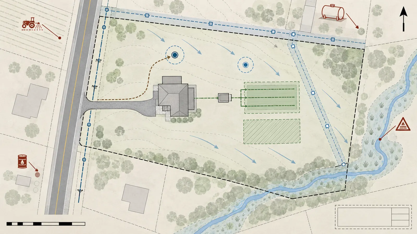
Do not draw the septic area after choosing a well point. Ask the designer to show both, plus a backup well point if the authority allows one. If the plan works only when the well is placed on the property line, over a recorded easement, in a drainage swale, beneath the future driveway, or inside the septic reserve area, it is not a robust feasibility result.
Use slopes and drainage as observations, not conclusions
Walk the parcel only to collect observations. Note high ground, low ground, swales, springs, wet areas, standing water, seasonal channels, fill, erosion, rock outcrops, dense vegetation, existing wells, buried utilities, animal areas, fuel tanks, manure, chemical storage, and evidence of flooding. Photograph locations from public or authorized access, label the date and direction, and place them on the sketch. Do not enter an unsafe excavation, climb a structure, move a well cap, probe soil, or expose yourself to contaminated water.
EPA states that proper well location and construction matter to well-water safety and recommends locating the well so rainwater flows away from it because surface water can pick up harmful bacteria and chemicals. Use EPA’s national siting guidance as a boundary, not as a replacement for local distances. The observation “this point is on a local high spot” may help a professional. It does not prove that the aquifer is protected, the point meets code, or a sample will be safe.
Record drainage direction separately from elevation. A point can be locally high but still sit downslope from a barnyard, septic component, road runoff path, or storage area. A contour map can miss a small berm, seasonal channel, recent grading, or buried feature. The local authority or qualified designer may require a field visit, survey, or sanitary evaluation.
Safety boundary for a remote buyer: do not diagnose, open, adjust, repair, or energize well pumps, pressure tanks, controls, wiring, or contaminated-water systems, and do not enter well pits, tanks, vaults, excavations, or other confined spaces. Leave covers and controls closed, keep other people out, and direct those tasks to a qualified well, pump, electrical, or water-treatment professional under the actual jurisdiction. OSHA identifies pits, tanks, and underground vaults as possible confined spaces, and Minnesota’s health department warns that only a properly trained licensed well contractor or licensed pump installer should enter a well pit. Read the OSHA confined-space guidance and Minnesota’s well-pit warning. Your safe role is to document locations from authorized ground, ask questions, preserve records, and stop when a professional or authority must take over.
Build a constraint overlay
The overlay should use a parcel boundary and a scale that lets a reviewer measure the relevant features. Add:
- property lines, roads, legal access, and recorded easements;
- existing and proposed structures, including the house, garage, accessory dwelling, and outbuildings;
- septic tank, treatment units, dispersal area, reserve area, and maintenance access;
- candidate well point and any required protective or sanitary-control radius;
- sewer lines, water mains, utility corridors, fuel tanks, animal areas, manure, chemical storage, and other contamination sources;
- streams, ponds, wetlands, drainageways, flood-prone areas, steep slopes, rock, fill, and known critical areas;
- a drilling route, staging area, truck turning space, overhead-wire clearance, and surface restoration area;
- the proposed water-line route to the house and electrical route to the pump equipment.
Every feature needs a source label: recorded plan, utility record, seller statement, field observation, survey, professional assessment, or unknown. “Unknown” is more useful than an unmarked assumption. If the well location depends on a boundary, easement, or setback within a few feet, do not scale it from an online image. Ask whether a survey is required.
Compare the rule to the layout in the correct jurisdiction
There is no single US private-well setback table. Illinois EPA, for example, says a well must be at least 10 feet from certain sewers with watertight joints, 50 feet from septic tanks and animal-confinement lots, and 75 feet from septic fields and manure piles. Those are Illinois-specific siting distances. They should not be copied into a Pennsylvania, Texas, Virginia, Washington, or other county plan.
Virginia’s regulation shows a different structure. Its Table 3.1 varies by well class and lists 50 feet from a pretreatment system, 100 feet from a sewage disposal system or other contaminant source for Class IIIC or IV wells, and special exceptions and minimums for sewer lines and mains. Read the complete Virginia table and its footnotes. The table is not a national design shortcut; it is a reminder to identify the well class, the source, the slope provisions, and the exceptions before measuring.
The practical rule is: use a state or county number only after recording the issuing authority, citation, well class or system type, measurement point, exception, and date. If a professional’s concept plan says “50-foot setback” without identifying the rule, ask what it measures from and why that rule applies. A line drawn at the correct distance from the wrong feature is still wrong.
Treat access as a feasibility gate
Drilling access is a design question, not a driveway impression. Official Texas Department of Transportation geotechnical guidance requires the site to be prepared before the crew arrives, notes that a truck-mounted mast cannot swing, and calls out level pads, overhead clearance, and access. Use that public equipment-planning example to structure questions, not as a residential-well rule. The driller may need a route from the public road to the flagged point, a turning or backing path, stable ground, clearance for mast or equipment, space for cuttings and water, and permission to cross an easement or neighboring land. Wet weather can change access. A route that works for a pickup may not work for the rig that the selected method requires.
Ask a licensed driller to review the route before you waive the feasibility condition. Provide the parcel plan, gate dimensions, bridge or culvert limits if known, overhead and underground utility information, slopes, surface conditions, and any access agreement. Ask the driller to list assumptions: equipment footprint, required clearance, maximum slope, need for temporary roadwork, water or power, spoil handling, restoration, and whether a different rig changes the plan. A driller’s preliminary route opinion is not a guarantee of depth or yield, but it can reveal a physical blocker that a map cannot.
The buyer is responsible for permission to access land; the driller is responsible for saying whether the proposed operation is within the equipment and safety limits they accept. Never direct a crew under an overhead line, across an unverified bridge, into a steep unstable area, or onto a neighboring parcel without written authorization. Electrical work, excavation, road construction, and work around wells or tanks belong to qualified professionals.
Decision after the layout gate
Proceed when the local professional can show at least one candidate well point and a wastewater design area on a scaled plan, access is authorized and plausible, and the authority has identified the review path. Require redesign or an extension when only one fragile layout works and it has not been reviewed. Stop when the well point and septic system cannot coexist, when a required easement cannot be obtained, or when safe drilling access cannot be established during the contract period.
Use nearby wells and maps as evidence, not as a promise #
Nearby wells can improve the questions you ask, but they cannot establish that your parcel will produce a dependable domestic supply, meet water-quality requirements, or receive approval. The correct use of records is comparative and bounded: identify patterns, data gaps, and professional questions, then verify the actual parcel through the local process.
What a well log may contain
A well log or completion report may include location, owner, date, total depth, casing, geologic layers, static water level, reported yield or test method, pump information, and completion notes. Fields vary by jurisdiction and by the age of the record. A point may be geocoded approximately, the depth may be measured from a different reference, the yield may be a short test, and the record may describe construction rather than long-term household performance.
Start a record table with the distance and direction from your parcel, record date, source agency, coordinates or legal description, well type, total depth, casing, reported yield, test duration or method, static level, water-quality information, and record confidence. Mark whether the well is actually in the same geologic setting, whether it lies upslope or downslope, whether it serves a different use, and whether the record is complete. Keep raw links and downloaded copies with the access date.
King County provides a useful local example of this record discipline: it says it maintains some private-individual water-source records because projects requiring an approved water source are reviewed by the county, and it points readers to county records and Washington well reports where available. Use the county’s records guidance to find the appropriate local record path. The phrase “some records” matters. A blank result is not proof that no well exists, and a record is not proof that your parcel will match it.
What comparison can and cannot tell you
Several nearby records can support a question such as, “Does the local drilling history show a consistent depth range or a recurring low-production concern that should change the professional scope?” One record cannot support, “Our well will be 300 feet deep and produce 10 gallons per minute.” Even a cluster can mislead if the points are separated by a fault, ridge, valley, confining layer, different aquifer, or different construction standard.
Use these comparisons carefully:
| Observation in nearby records | Reasonable use | Unsafe inference | Next question |
|---|---|---|---|
| Similar depths within a small area | Ask a driller or hydrogeologist whether the pattern is relevant | Your well will reach water at the same depth | How comparable are location, formation, season, and construction method? |
| One high reported yield | Flag a possible productive zone | Your well will have the same yield | What test method and duration produced the number? |
| Several low-yield reports | Increase contingency and investigate seasonal risk | A well is impossible | What local standard, storage strategy, or alternate source is allowed? |
| Different casing or well types | Recognize changing geology or standards | The cheapest construction is acceptable | Which current construction class and license apply? |
| No nearby records | Treat the evidence gap as uncertainty | No groundwater exists | Does the records agency have incomplete coverage or another index? |
| Water-quality result from another well | Identify analytes worth discussing | Your water is safe or unsafe | Which tests does the local authority and lab recommend for this parcel? |
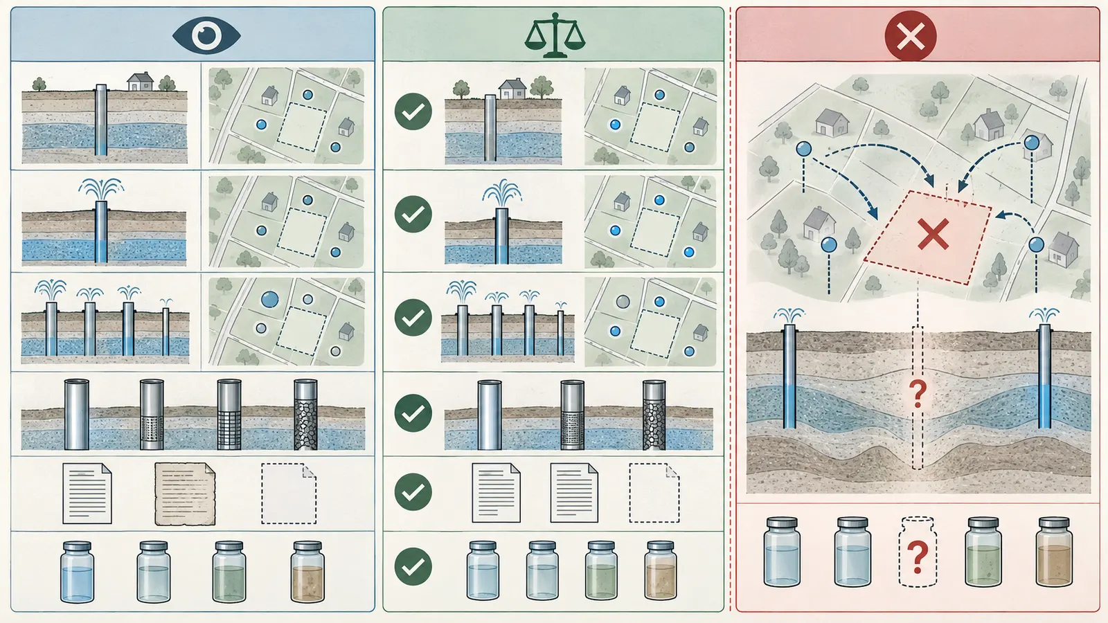
If a seller gives you a neighbor’s log, ask permission to contact the owner only through an appropriate channel and do not represent a private conversation as an official record. A neighbor’s experience can be useful context but is not a permit, test report, or professional opinion about the subject parcel.
Maps are screening tools
A groundwater atlas, aquifer map, recharge map, drought map, or state geological layer can help you understand regional context and choose better questions. It may show an area classification or modeled condition, not the depth, yield, quality, legal eligibility, or site-specific construction outcome of a lot. Even a high-confidence map cell is not a parcel approval.
Record the map title, publisher, scale, date, layer, resolution, and stated limitations. If the map is intended for regional planning, do not cite it as a property-level determination. Ask the state geological survey or health authority how the layer should be used. A map that says “groundwater present” answers a regional question; it does not answer “can a licensed professional construct an approved domestic well here and can the county issue a dwelling permit?”
Do not predict yield from household demand alone
A family’s expected daily use is relevant to design, but it is not a groundwater prediction. New York State Department of Health explains that a low-yield well may meet total daily household demand while failing to meet peak demand, and that supplemental storage can help meet peak demand; its numbers are New York guidance, not a national acceptance standard. See the state’s yield-and-storage explanation. A modest well may work with storage if the actual authority and professional accept the design; treatment, pressure, pump power, and fire-flow expectations can change the system.
Seasonal behavior is a separate uncertainty. USGS says well water levels depend on depth, aquifer type, pumping, and recharge, and that shallow wells in unconfined aquifers are more directly affected by a lack of rain. Use USGS to ask how season and drought should affect the test scope. A local minimum may not match your household’s peak demand or the approval standard, and one favorable test date cannot establish long-term performance.
Ask the authority and professional to name the quantity test, acceptance threshold, test duration, season, recovery observation, and measurement method. King County, Washington illustrates how local review can be more specific than a generic “gallons per minute” conversation: its guidance calls for a pump-test report and adds longer testing and a daily-production demonstration in certain low-flow cases. Those are King County requirements, not national minimums.
Water quality is a separate uncertainty
A well can have enough water and still require treatment or fail a required sample. A clean-looking spring, a deep well, or a neighbor’s clear water is not a laboratory result. Tests also have scope: Virginia Department of Health says the coliform test required for a newly constructed Virginia private well does not cover all contaminants, and it recommends situation-specific testing such as bacteria, nitrate, radiological constituents, or chemicals of concern. Use Virginia’s guidance as a precise state example of why one sample has limits. One result does not establish future stability. Ask the local health authority and a certified laboratory what must be tested, who must collect it, where the sample tap is, how the sample is preserved, and what happens after an unsatisfactory result.
King County’s application guide lists two coliform samples, nitrate below 10 mg/L or 10 ppm, and arsenic below 0.01 mg/L or 10 ppb for its local review. Use that list only as a King County example of how a jurisdiction can specify tests and thresholds. Do not promise that those are the only or correct tests for a lot in another jurisdiction.
Decision after the evidence gate
Continue only when the records and maps are being used to refine a professional scope, not to replace it. Increase the contract protection when the record set is sparse, inconsistent, old, seasonally biased, or near a known contamination source. If the seller or broker presents a neighboring log as proof, write “unverified comparative evidence” in the ledger and require a parcel-specific review before waiving the condition.
Move from desktop research to a written local feasibility scope #
The purchase decision should turn on a written scope that names what will be checked, by whom, under which jurisdiction, by what date, and what outcome allows the buyer to proceed. A driller, septic designer, engineer, health official, utility, or attorney each owns a different part of that handoff; no single person should be assumed to certify the whole project unless their written scope and authority actually cover it.
Choose professionals by the unresolved gate
Use the ledger to choose the right professional, not the most general “well inspection” product.
- Utility or water-service specialist: public-water boundary, connection, extension, availability, and service obligations.
- Planning or building official: whether the proposed private source can support a dwelling, accessory unit, or occupancy in that jurisdiction.
- Health department or authorized reviewer: well-site approval, septic process, contamination setbacks, sampling, inspection, and local forms.
- Licensed septic designer or soil professional: wastewater location, soil or site evaluation, primary and reserve areas, treatment, and maintenance access.
- Licensed well driller: drilling access, equipment assumptions, construction method, completion record, testing, and site-specific limitations.
- Water-system engineer or hydrogeologist: complex geology, shared systems, low production, contamination, unusual treatment, or a need to synthesize multiple records.
- Real-estate attorney or other jurisdiction-appropriate counsel: contingency wording, deadlines, access rights, easements, covenants, representations, and remedies.
- Land surveyor: boundary, easement, line, elevation, or setback uncertainty that cannot safely be resolved by scaling.
EPA advises owners to use a state licensing agency, local health department, or local water-system professional for local construction information and to check that drillers and pump installers are bonded, insured, and licensed or certified when required. Use the EPA guidance as the national hiring boundary. The buyer still must verify the specific license and scope in the actual state.
Write a bounded assignment
A useful pre-purchase scope says what is included and excluded. For example:
Review parcel [number] in [county/state] for a proposed single-family residence with [bedrooms], [accessory uses], and onsite wastewater. Identify public-water requirements, a primary and backup candidate well location if permitted, the wastewater and reserve areas, apparent contamination sources, access assumptions, the authority and application needed before drilling, records reviewed, unanswered questions, and recommended contract conditions. This is a preliminary feasibility opinion and does not guarantee groundwater quantity, quality, permit issuance, construction cost, or long-term performance.
Ask for a plan, not just a phone call. The plan should show north arrow, scale, parcel boundary, candidate well point, house, septic components, reserve area, driveway, access, surface water, drainage, known sources, easements, and any uncertainty. Ask the professional to identify which items were verified in the field, which came from records, and which remain assumptions.
Verify the local sequence before spending on drilling
The sequence normally has a gate before construction and a different set of tests and records after construction. King County’s process is a clear example: a licensed septic designer or professional engineer submits the application; a county inspector reviews the application and proposed site; preliminary site approval comes before a licensed driller constructs the well; then a well report, pump test, water-quality samples, and recorded covenants complete review. See the full King County start-to-finish sequence.
This matters to a buyer because “we can drill during the contingency” may be wrong in two ways. The authority may require a site application and preliminary approval before drilling, and drilling may still not establish an approved residential water source until post-construction testing and records are accepted. Put the sequence in the contract timeline. If the application itself cannot be filed before closing, the contingency should not pretend that a later permit is already likely.
Virginia’s regulations offer another local sequence example. They state that after construction the owner or agent submits a contractor-signed completion statement, the local health department inspects, corrections are made if necessary, and an inspection statement is issued before operation. They also connect the inspection statement to an occupancy permit and specify that the inspection statement is not a performance warranty. Read the Virginia permit, inspection, completion, and warranty provisions. A buyer in Virginia must confirm the current rule and local implementation with the district health department; a buyer elsewhere must not borrow the sequence without checking the actual authority.
Decide what “written feasibility” must say
A useful letter or report should answer these questions:
- What parcel, proposed use, and jurisdiction were reviewed?
- What public-water records and authority responses were obtained?
- Is the private-well path legally eligible, conditionally eligible, or not determined?
- What well point or points were considered, and what plan shows them?
- What septic and reserve areas were considered, and by what professional?
- Which local rules or permit documents control the location and sequence?
- What access, easement, slope, overhead, surface, or staging limitations remain?
- What neighboring records and maps were reviewed, and what are their limitations?
- What test or inspection would resolve each open quantity or quality question?
- Who must do the next action, by what date, and what document results?
- What fact would cause the professional to recommend stopping or redesigning?
Reject a report that promises “water guaranteed,” uses a regional map as the conclusion, gives a depth with no method or uncertainty, says “permitted” when no permit exists, or treats a septic sketch as an approved design. Reject a report that does not name the parcel or proposed use. A generic letter may be cheaper but is not evidence for a specific purchase.
The professional handoff packet
Send one organized packet to every professional so they can identify contradictions:
- Purchase agreement and feasibility deadline, with private financial terms redacted if unnecessary.
- Parcel number, legal description, deed or plat, survey, easements, and access rights.
- Listing, seller disclosures, prior permits, prior site plans, and known wells or septic systems.
- Utility map, public-water response, sewer response, and planning or building response.
- Topographic or parcel map with your observations clearly labeled as observations.
- Proposed house, bedrooms, accessory uses, driveway, grading, and utility concept.
- Nearby well records with source, date, location confidence, and raw links.
- The ledger with every open row and the question you want answered.
Ask professionals to return redlines or a revised plan, not only a narrative. The next professional should be able to see where the preceding one stopped. A septic designer may need to shift the well point; the building official may change the permitted use; the utility may eliminate the private path; the driller may reject the route. That is a healthy sequence when the changes happen before the contract becomes irreversible.
Decision after the professional gate
Proceed toward a purchase only when the written scope identifies a legally plausible source, a workable preliminary layout, a known approval sequence, a safe access plan, and specific remaining tests. Condition the purchase when the authority or professional will not complete the decisive step before closing but can identify the exact approval, testing, or access condition that protects you. Stop when the written opinion says the public source is required or the private path is not legally available, the layout cannot meet local requirements, or the unresolved risk is larger than the buyer’s budget and contract protection.
Put the sequence and failure branches into the purchase decision #
The final decision is contractual as well as technical: either the buyer can investigate and leave, or the buyer is accepting a defined risk. A vague “subject to well and septic” sentence is not a feasibility plan unless the attorney makes the condition measurable, timed, and enforceable under the governing contract and state law.
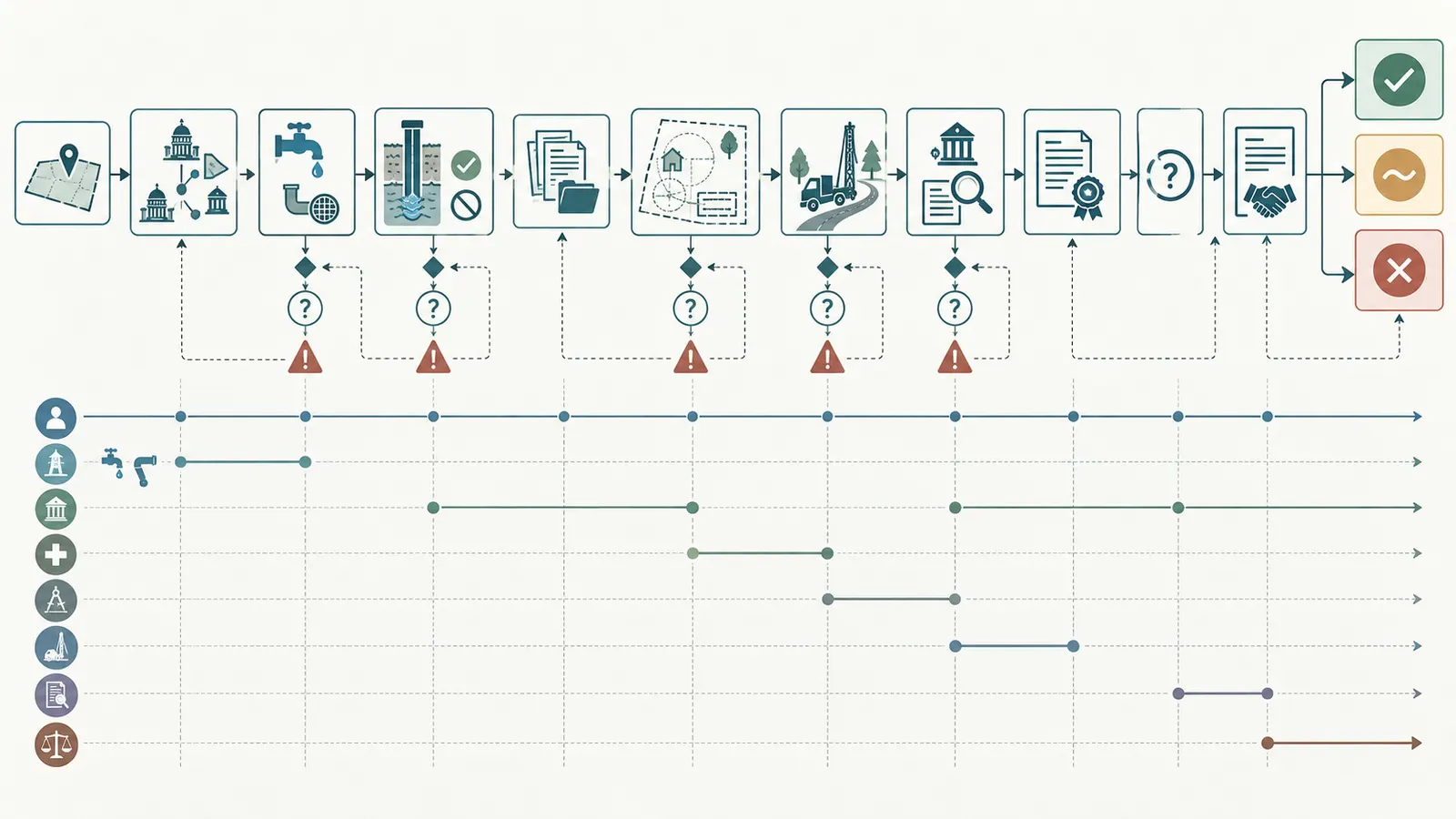
A practical sequence before closing
Use this order, adapting the names and forms to the actual state, county, city, and utility:
- Identify the parcel. Match the listing to the assessor, recorded plat, deed, parcel number, legal description, access, and lot-creation history.
- Identify the authorities. List utility, planning/building, health, state well records and licensing offices, title/recorder, and any special district.
- Check public water and sewer. Get written service, connection, availability, or nonavailability answers for the parcel and proposed residence.
- Check legal eligibility. Ask the health and building authorities whether a private well can be used as the domestic source and what pre-drilling application is required.
- Collect records. Retrieve nearby well logs, prior permits, septic records, plats, easements, environmental or critical-area records, and utility maps.
- Prepare the layout. Have a qualified septic designer or appropriate site professional place a candidate well, wastewater system, reserve area, house, driveway, drainage, and access on a scaled plan.
- Review access and safety. Have the driller or relevant professional verify route assumptions, equipment access, overhead clearances, and permission to use the route.
- Request local pre-review. Submit or discuss the site plan with the actual health authority if that is the local gate; do not drill early just to create evidence.
- Obtain written feasibility. Capture the open questions, professional limits, next documents, and conditions that change the recommendation.
- Set contract conditions. Have counsel specify access, deadlines, cost responsibility, authority approvals, professional reports, termination rights, refunds, and extension mechanics.
- Make the decision. Keep investigating only if the unresolved work is feasible within the protected period; require the written condition if approval comes later; stop if the decision cannot be verified at acceptable risk.
Branch: the utility says public water is available
Do not proceed with a private-well study simply because the connection cost feels high. Ask the building authority whether private supply is prohibited or whether a well can coexist with the required connection. Ask the utility for the physical and contractual scope, then compare it with the private path using the same level of uncertainty. The next decision may be whether the lot still works financially, not whether it has groundwater.
Branch: the utility says service is nearby but cannot confirm connection
Keep the private path unresolved. Request a parcel-specific engineering or availability response and ask who owns a main extension, easement, crossing, meter, and future maintenance. Do not let the seller’s statement “utility at the road” substitute for legal service ability. If the utility will not respond within the contingency period, condition closing on its written answer or stop.
Branch: the health authority will review a well but the building authority is silent
Ask the building authority explicitly whether the private source supports the proposed residence. King County’s guidance makes this separation direct: even after public-health approval, the building-permitting authority decides whether the source can support development. Use the King County example to ask your own jurisdiction who owns the final development decision. If no office will identify the final gate, the buyer does not yet have a usable feasibility result.
Branch: the only well point conflicts with septic
Do not solve the conflict by moving a point on a screenshot or accepting a smaller reserve area without authority and professional review. Ask the septic designer whether the wastewater system can move, be redesigned, or use a different treatment approach allowed by local rules. Ask the health authority whether the well protection area, setbacks, and easements can be satisfied. If the conflict requires a variance, treat the variance as a separate approval risk with its own written process and deadline. A possible variance is not the same as an issued variance.
Branch: the lot is small or its creation date matters
Obtain the recorded plat, deed history, lot-segregation evidence, and the actual rule. King County uses a five-acre threshold for individual/private-well applications, with an exception described for lots created before May 18, 1972, and requires proof of lot creation date for a smaller lot. That is a King County rule example, not a national lot-size threshold. In another jurisdiction, the controlling fact may be subdivision date, public-water availability, density, water-management area, or a different lot standard.
If the seller says the lot is “grandfathered,” ask which agency recognizes that status and what document proves it. A tax parcel’s current size alone may not establish the legal history. Put the document request in the contingency checklist.
Branch: the seller will not allow access
Do not trespass, enter an unsafe site, or send a driller without written permission. Ask the seller to authorize a defined inspection window, route, equipment class, restoration obligation, and insurance arrangement. If access cannot be granted, the buyer cannot complete the field verification. Treat that as an unresolved material condition, not as an invitation to rely on remote evidence.
Branch: nearby records look excellent
Keep the parcel-specific professional review. A neighboring 600-foot well that produces well may be encouraging, but it does not establish your location, construction, chemistry, legal eligibility, or seasonal behavior. Put the record in the ledger as “comparative evidence” and ask the driller or hydrogeologist how much weight it deserves. If no professional will rely on it as predictive, neither should the buyer.
Branch: a driller gives a depth or yield estimate
Ask for the basis, range, assumptions, test method, and what happens if the result is different. A drilling estimate can inform budget and contingency design, but it is not a guarantee. Ask whether the estimate includes mobilization, casing, grouting, development, pump, power, trenching, treatment, testing, permits, restoration, and a dry-hole or low-yield outcome. Never sign a contract that makes a single favorable depth the only acceptance condition unless a qualified attorney and professional have defined what that means under local rules.
Branch: the authority says a permit can be issued without a site visit
Ask what the applicant is certifying and what happens if the field installation does not match the plan. Virginia’s express Class IV permit pathway requires the owner to acknowledge that the permit may issue without a local health department site visit before issuance; it also says that a well found noncompliant with the chapter’s separation or other requirements must be abandoned at the local or district health director’s direction. Read the current Virginia Administrative Code provision and its limited scope. The rule also requires inspection before operation. In the buyer’s jurisdiction, ask who bears correction, abandonment, replacement, and restoration costs; do not transfer Virginia’s Class IV pathway to another state.
Branch: a well is approved but the buyer wants a larger home
Return to the proposed use. A source approved for one residence may not automatically support an accessory dwelling, additional parcel, livestock, irrigation, commercial use, or future subdivision. Ask the building, health, and utility authorities what change triggers a new review. Update the ledger before closing if the household brief changes.
Branch: the quality result passes one required test
Record exactly what was tested, by which lab, when, from which tap, using which collection method, and what was not tested. Do not call the water “safe” without defining the claim. Ask whether treatment, monitoring, retesting, a covenant, or a notice is required. The buyer’s future obligations can be more important than the initial result.
Make the next decision explicit and preserve the evidence #
The correct endpoint is a documented decision with a next owner and date: continue investigation, require a written feasibility condition, or stop before purchase commitment. Preserve the source records and review dates because approvals, utility maps, contact answers, and seller representations can change, expire, or apply only to a particular use.
Three decision outcomes
Keep investigating when the parcel has a plausible source path, the local authorities identify the process, the scaled layout has at least one candidate solution, access is authorized, and the remaining questions can be answered within the inspection period. Keep the condition open until the named document or professional report arrives.
Require a written local feasibility condition when a key decision belongs to an authority or professional who cannot complete it until after the offer, but the seller will permit access and the contract can protect the buyer. The condition should name the parcel, proposed use, authority, required application or report, acceptance criteria, deadline, termination and refund mechanics, cost responsibility, and extension process. Have a jurisdiction-appropriate real-estate attorney draft or review it.
Stop before the purchase commitment when the water source is not legally available, the public-water path is required but unworkable, no compliant well-and-septic layout exists, access is unavailable, critical records cannot be verified, or the buyer would be accepting an undefined financial or health risk. Stopping is a successful feasibility outcome; it prevents the lot from dictating a later emergency decision.
Final buyer checklist
Before waiving the feasibility condition, confirm all that apply:
- Parcel number, legal description, lot area, lot history, zoning, and access match the proposed purchase.
- The public-water and sewer authorities have answered for this parcel and proposed residence.
- The building or planning authority has identified whether a private source may support the dwelling.
- The health authority has identified the well and septic application, review, and pre-drilling sequence.
- The actual state and county or city rules are recorded next to every setback, lot-size, permit, test, and licensing claim.
- A qualified professional has placed a candidate well, septic system, reserve area, house, driveway, drainage, and utility routes on one scaled plan.
- Access, route, equipment, overhead clearance, easements, staging, and restoration assumptions are documented.
- Nearby well logs and maps are labeled comparative and limited; none is being used as a yield, safety, or approval guarantee.
- The required professional, authority, lab, test, sample, inspection, and completion documents are named.
- Every unresolved row has a responsible party, deadline, confidence statement, and next verification.
- The contract protects access, investigation time, report delivery, approval conditions, refund rights, and extension decisions.
- The proposed home, accessory uses, occupancy, water demand, and wastewater demand match what was reviewed.
Keep the evidence package usable after closing
If you buy the lot, preserve the ledger with the title file, permits, approved plans, well report, pump and water-quality tests, covenants, easements, utility correspondence, invoices, inspection statements, and the final as-built locations. Future owners and future professionals need to know not only what was approved but what assumptions were made. If you do not buy it, keep the research long enough to document why the decision changed and prevent a future listing or memory from turning an open question into a supposed fact.
The ledger should also carry forward maintenance consequences. Under the actual jurisdiction, identify who is responsible for the wellhead, pump, pressure equipment, power, treatment, sampling, records, access, and eventual repair or abandonment, and what documents or deadlines prove that responsibility. Those questions are not reasons to reject every well-served lot, but they belong in the ownership decision before the purchase price is treated as the full cost of the home.
Virginia provides an exact example of the boundary: its inspection-statement rule says approval is not a warranty of water quality, quantity, or a specified operating period, and assigns the owner or subsequent owner responsibility to maintain, repair, replace, or comply with abandonment requirements. See the Virginia owner-duty language. Other jurisdictions use different rules, forms, and deadlines, so record the actual authority before closing rather than treating “maintenance” or “abandonment” as a generic national duty.
Finally, revisit the authority before acting on old research. A webpage date, permit term, utility boundary, health rule, lot use, or local application process can change. The correct refresh is substantive: ask the authority to confirm the current rule for the parcel, update the plan when the house or septic design changes, and record the new answer. A cosmetic date change in the ledger is not verification.
The decisive question remains simple even when the work is not: can this parcel receive an approved domestic water source in the actual jurisdiction, on a workable site, with a protected sequence and a risk the buyer knowingly accepts? If the evidence does not answer that question, the next decision is to protect the investigation—or walk away.
Cite this guide
Brictale. “How to Assess Private-Well Feasibility for a Vacant Lot Before Buying.” Published 2026-09-21; updated 2026-09-21.
https://brictale.com/build/land/assess-private-well-feasibility-vacant-lot-before-buying · Read the Markdown version
Original contribution: Private-well feasibility ledger. A parcel-specific ledger that separates public-water status, local approval gates, proposed well and septic locations, access, nearby records, responsibility, confidence and the next verification.
Sources and scope
Evidence behind this page
- EPA says proper well location and construction are important to private-well safety and that the well should be located so rainwater flows away from it because surface water can carry bacteria and chemicals toward the well.
Learn About Private Water Wells | US EPA
United States national educational guidance; not a substitute for the parcel's health-department siting rule.
Accessed · Link to this claim - Illinois EPA states that a new well must be at least 10 feet from certain watertight-joint sewers, 50 feet from septic tanks and animal-confinement lots, and 75 feet from septic fields and manure piles.
Location and Construction of New Private Wells
Illinois only; these distances are an Illinois example and must not be generalized to another state or county.
Accessed · Link to this claim - King County, Washington guidance says new individual/private-well applications are for lots without a previously approved water source when connection to a Group A or Group B public water system is not possible; it identifies a five-acre threshold or proof that a smaller lot was created before May 18, 1972, and says the jurisdictional building authority ultimately decides whether the well may support development.
How to Apply for a New Individual/Private Well in the Public Health Permit Center
King County, Washington; examples of local public-water, lot-age and building-authority gates for an individual private well.
Accessed · Link to this claim - King County's new individual/private-well process has a licensed septic designer or professional engineer submit the application, a county inspector review and inspect the proposed site, preliminary site approval before drilling, then post-drilling well-report, pump-test, water-quality and covenant submissions.
How to Apply for a New Individual/Private Well in the Public Health Permit Center
King County, Washington; a local sequence example, not a national permitting workflow.
Accessed · Link to this claim - For a new individual/private well, King County lists an Ecology well report, a pump-test report, two coliform samples with bacteria absent, nitrate below 10 mg/L or 10 ppm, arsenic below 0.01 mg/L or 10 ppb, and recorded covenants among the documents used to complete review.
How to Apply for a New Individual/Private Well in the Public Health Permit Center
King County, Washington; local review documents and thresholds that cannot be presented as universal US requirements.
Accessed · Link to this claim - King County says it maintains some private-individual water-source records because new projects and permits requiring an approved source are reviewed and approved by the county, and it points readers to county records and Washington well-report records where available.
Finding information on your water quality | King County
King County, Washington; demonstrates a local record-search path and the limits of record availability.
Accessed · Link to this claim - King County requires all water systems serving two or more parcels to be permitted as Group B public water systems; its category guidance describes Group B systems as serving 2–14 connections.
Forms, applications, covenant templates, and resources | King County
King County, Washington; local classification and permitting guidance for shared or multi-parcel water systems, not a national rule.
Accessed · Link to this claim - King County says a private well may not be the correct path when a public water connection is available or required, and that its public-health review is followed by a local-services decision on whether the private well is an adequate and legal source.
Creating or replacing a water system | King County
King County, Washington; illustrates the separation between health review and the jurisdictional development/water-service decision.
Accessed · Link to this claim - Virginia's private-well regulations state that local or district health departments implement and enforce the regulations; a well contractor constructing a water well to reach groundwater must possess at least a valid Class B contractor license; and the well permit and inspection statement connect to the building-permit and occupancy process.
Private Well Regulations, 12 VAC 5-630-10 et seq.
Commonwealth of Virginia; legal and administrative example, not a national contractor-licensing rule.
Accessed · Link to this claim - Virginia requires a completion statement, health-department inspection and inspection statement before a private well is placed in operation, but the inspection statement does not warrant or guarantee that the well will function for a specified period.
Private Well Regulations, 12 VAC 5-630-10 et seq.
Commonwealth of Virginia; demonstrates why approval is not the same as a performance guarantee.
Accessed · Link to this claim - Virginia Table 3.1 lists separation distances by well class, including 50 feet from a pretreatment system, 100 feet from a sewage disposal system or other contaminant source for Class IIIC or IV wells, and special rules for house sewer lines and sewer mains.
Private Well Regulations, 12 VAC 5-630-10 et seq.
Commonwealth of Virginia; table values are jurisdiction-specific and depend on well class and exceptions in the regulation.
Accessed · Link to this claim - EPA says septic-system type and size depend on lot size, slope, soil conditions, home size or occupancy, local and state regulations, and budget; under most regulatory programs the local permitting agency conducts a site assessment, and local rules set setbacks from buildings, driveways, property lines, and surface waters.
Frequent Questions on Septic Systems
United States EPA national guidance; describes common regulatory structure and directs readers to the local permitting authority for the controlling rule.
Accessed · Link to this claim - EPA explains that septic effluent moves through soil toward groundwater, that a drinking-water well is at greater risk when it lies in groundwater flow beneath a septic system, and that most states or local governments set a horizontal setback between septic components and drinking-water wells.
Septic Systems and Drinking Water
United States EPA national educational guidance; the actual separation distance remains jurisdiction-specific.
Accessed · Link to this claim - The Texas Department of Transportation's geotechnical field-testing guidance says drill sites should be prepared before the crew arrives, notes that a truck-mounted mast cannot swing, and addresses level pads, overhead clearance, and access; it is an equipment-planning example rather than a residential-well rule.
Texas Department of Transportation geotechnical field-testing guidance; use only to frame questions about rig access and site preparation, not as a permit requirement for a vacant-lot well elsewhere.
Accessed · Link to this claim - New York State Department of Health explains that a low-yield well may meet total daily household demand but fail to meet peak demand, and that supplemental storage can help meet peak demand; its yield and storage values are New York guidance, not a national acceptance standard.
Individual Water Supply Wells - Fact Sheet #2
New York State Department of Health; illustrates the distinction between sustainable yield, daily demand, peak demand, and storage without establishing a national design rule.
Accessed · Link to this claim - USGS says well water levels depend on well depth, aquifer type, pumping, and recharge; shallow wells in unconfined aquifers are more directly influenced by a lack of rain, so seasonal or drought conditions can change the observed water level.
Ground Water and the Rural Homeowner
United States Geological Survey educational guidance; explains mechanisms and uncertainty, not a prediction for a particular parcel.
Accessed · Link to this claim - Virginia Department of Health says newly constructed private wells must be tested for coliform organisms, but that test does not cover all contaminants; it recommends broader, situation-specific testing and says prospective homebuyers may test private-well water even though home-purchase testing is not required by VDH.
Guidance on testing your private well water
Virginia Department of Health; local testing and purchase requirements may differ outside Virginia.
Accessed · Link to this claim - Virginia's 12VAC5-630 express Class IV permit pathway requires the owner's acknowledgment that the permit may issue without a local-health-department site visit before issuance and that a well found noncompliant with minimum separations or other chapter provisions must be abandoned at the local or district health director's direction; the rule is limited to that pathway and its conditions.
Virginia Administrative Code, 12VAC5-630 Private Well Regulations
Commonwealth of Virginia; specifically the express Class IV construction-permit pathway and its inspection/abandonment conditions, not a national rule or a description of every Virginia well permit.
Accessed · Link to this claim - Virginia's private-well regulation says an inspection statement is not a warranty of water quality, quantity, or a specified operating period and places responsibility on the owner or subsequent owner to maintain, repair, replace, or comply with private-well abandonment requirements.
Virginia Administrative Code, 12VAC5-630 Private Well Regulations
Commonwealth of Virginia; an exact legal example of owner and subsequent-owner duties, not a universal US maintenance or abandonment rule.
Accessed · Link to this claim - OSHA identifies pits, tanks, and underground vaults as examples of confined spaces and explains that permit-required spaces can present hazardous-atmosphere, engulfment, configuration, or other serious hazards.
Confined Spaces in Construction: Pits
United States OSHA construction safety guidance, paired with state health guidance for well pits; supports a conservative reader boundary and does not authorize homeowner entry or repair.
Accessed · Link to this claim - Minnesota Department of Health warns that well pits can present injury or asphyxiation danger and says only a properly trained licensed well contractor or licensed pump installer should enter a pit; it also says unused wells must be properly sealed by a licensed well contractor.
Minnesota Department of Health; safety and sealing guidance is jurisdiction-specific, while the no-entry boundary is a conservative homeowner safety instruction.
Accessed · Link to this claim